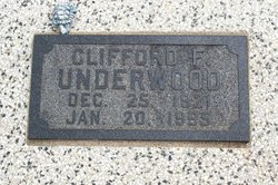
Clifford Francis Underwood
| Birth | : | 25 Dec 1921 USA |
| Death | : | 20 Jan 1995 Kansas, USA |
| Burial | : | SS Peter & Paul Churchyard, Shelford, Rushcliffe Borough, England |
| Coordinate | : | 52.9745600, -1.0161200 |
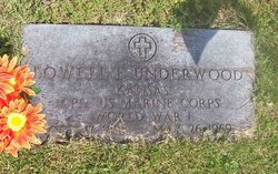
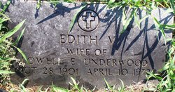
| Description | : | Clifford Francis Underwood, 73, died Jan. 20, 1995. He was born Dec. 25, 1921, in Blue Mound, the son of Lowell E. and Edith Viola Briggs Underwood. He married Wilma Clayton on May 16, 1942, in Mapleton. |
frequently asked questions (FAQ):
-
Where is Clifford Francis Underwood's memorial?
Clifford Francis Underwood's memorial is located at: SS Peter & Paul Churchyard, Shelford, Rushcliffe Borough, England.
-
When did Clifford Francis Underwood death?
Clifford Francis Underwood death on 20 Jan 1995 in Kansas, USA
-
Where are the coordinates of the Clifford Francis Underwood's memorial?
Latitude: 52.9745600
Longitude: -1.0161200
Family Members:
Parent
Spouse
Children
Flowers:
Nearby Cemetories:
1. SS Peter & Paul Churchyard
Shelford, Rushcliffe Borough, England
Coordinate: 52.9745600, -1.0161200
2. Shelford Priory
Shelford, Rushcliffe Borough, England
Coordinate: 52.9830600, -0.9994100
3. St Luke's Churchyard
Stoke Bardolph, Gedling Borough, England
Coordinate: 52.9680500, -1.0389300
4. St. Luke's Churchyard
Stoke Bardolph, Gedling Borough, England
Coordinate: 52.9659896, -1.0404380
5. Burton Joyce Cemetery
Burton Joyce, Gedling Borough, England
Coordinate: 52.9863100, -1.0370710
6. St. Helen's Churchyard
Burton Joyce, Gedling Borough, England
Coordinate: 52.9866700, -1.0365400
7. St John the Baptist Gunthorpe
Gunthorpe, Newark and Sherwood District, England
Coordinate: 52.9925600, -0.9877400
8. Saint Peter Churchyard
East Bridgford, Rushcliffe Borough, England
Coordinate: 52.9809170, -0.9726560
9. St Mary Churchyard
Radcliffe-on-Trent, Rushcliffe Borough, England
Coordinate: 52.9464660, -1.0419420
10. Radcliffe-on-Trent Cemetery
Radcliffe-on-Trent, Rushcliffe Borough, England
Coordinate: 52.9459200, -1.0409700
11. All Hallows Churchyard
Gedling, Gedling Borough, England
Coordinate: 52.9769400, -1.0805130
12. Lowdham Saint Mary Churchyard Extension
Lowdham, Newark and Sherwood District, England
Coordinate: 53.0143500, -1.0125800
13. St Mary the Virgin Churchyard
Lowdham, Newark and Sherwood District, England
Coordinate: 53.0146670, -1.0135510
14. Gedling Cemetery
Gedling, Gedling Borough, England
Coordinate: 52.9806930, -1.0870670
15. Carlton Cemetery
Nottingham, Nottingham Unitary Authority, England
Coordinate: 52.9682820, -1.0900230
16. St Mary and All Saints Churchyard
Bingham, Rushcliffe Borough, England
Coordinate: 52.9522920, -0.9484950
17. St Laurence's Churchyard
Gonalston, Newark and Sherwood District, England
Coordinate: 53.0201000, -0.9845830
18. St Michael Churchyard
Hoveringham, Newark and Sherwood District, England
Coordinate: 53.0124370, -0.9603240
19. Woodborough Cemetery
Woodborough, Gedling Borough, England
Coordinate: 53.0272840, -1.0600540
20. St. Paul's Churchyard
Nottingham Unitary Authority, England
Coordinate: 52.9667590, -1.1172140
21. St Giles Churchyard
Cropwell Bishop, Rushcliffe Borough, England
Coordinate: 52.9127600, -0.9831300
22. All Saints Churchyard
Cotgrave, Rushcliffe Borough, England
Coordinate: 52.9116900, -1.0436100
23. St John of Beverley Churchyard
Scarrington, Rushcliffe Borough, England
Coordinate: 52.9667400, -0.9071900
24. St. Mary Rest Ground
Nottingham, Nottingham Unitary Authority, England
Coordinate: 52.9568310, -1.1406580


