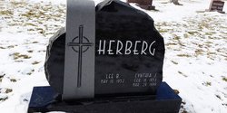
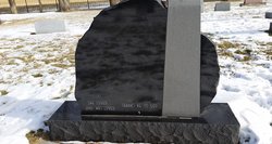
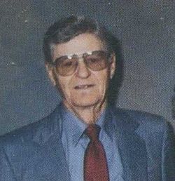
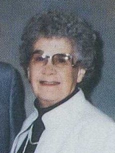
Cynthia Joy Opdahl Herberg
| Birth | : | 16 Feb 1953 Valley City, Barnes County, North Dakota, USA |
| Death | : | 29 Mar 1999 Litchville, Barnes County, North Dakota, USA |
| Burial | : | Beth Israel Cemetery, Coatesville, Chester County, USA |
| Coordinate | : | 40.0053497, -75.8470131 |
| Description | : | CYNTHIA "CINDY" J. HERBERG Cindy Herberg, 46, Litchville, North Dakota, died Monday, March 29, 1999 at her home. Funeral services were held April 1 at Our Saviour's Lutheran Church, Valley City, North Dakota. A prayer service was held March 31 at First Lutheran Church in Litchville. Cynthia Joy Opdahl was born February 16, 1953 in Valley City, the daughter of Alfred and Evelyn (Storhoff) Opdahl. Cindy grew up in Litchville and graduated from Litchville High School in 1971. She was married to Michael Stephenson and they lived in West Fargo and Valley City. She was employed at Gate City Savings and... Read More |
frequently asked questions (FAQ):
-
Where is Cynthia Joy Opdahl Herberg's memorial?
Cynthia Joy Opdahl Herberg's memorial is located at: Beth Israel Cemetery, Coatesville, Chester County, USA.
-
When did Cynthia Joy Opdahl Herberg death?
Cynthia Joy Opdahl Herberg death on 29 Mar 1999 in Litchville, Barnes County, North Dakota, USA
-
Where are the coordinates of the Cynthia Joy Opdahl Herberg's memorial?
Latitude: 40.0053497
Longitude: -75.8470131
Family Members:
Parent
Siblings
Flowers:
Nearby Cemetories:
1. Beth Israel Cemetery
Coatesville, Chester County, USA
Coordinate: 40.0053497, -75.8470131
2. Saint Stanislaus Kostka Polish Catholic Cemetery
Coatesville, Chester County, USA
Coordinate: 40.0046349, -75.8459930
3. West Caln Baptist Cemetery
Wagontown, Chester County, USA
Coordinate: 40.0172005, -75.8491974
4. West Caln Friends Burial Ground
Wagontown, Chester County, USA
Coordinate: 40.0109000, -75.8694000
5. Hibernia United Methodist Cemetery
Cedar Knoll, Chester County, USA
Coordinate: 40.0250015, -75.8339005
6. New Evergreen Cemetery
Coatesville, Chester County, USA
Coordinate: 39.9810220, -75.8495130
7. Holy Ghost Ukrainian Orthodox Cemetery
Valley Township, Chester County, USA
Coordinate: 39.9805984, -75.8516998
8. Dawson Family Cemetery
West Caln Township, Chester County, USA
Coordinate: 40.0009930, -75.8796790
9. Saint Nicholas Russian Orthodox Cemetery
Coatesville, Chester County, USA
Coordinate: 39.9794000, -75.8516000
10. Saint Cecelia's Roman Catholic Cemetery
Coatesville, Chester County, USA
Coordinate: 39.9906006, -75.8114014
11. Coatesville Presbyterian Cemetery
Coatesville, Chester County, USA
Coordinate: 39.9831543, -75.8184738
12. Fairview Cemetery
Coatesville, Chester County, USA
Coordinate: 39.9789009, -75.8071976
13. Lutheran Church of the Good Shepherd Columbarium
Coatesville, Chester County, USA
Coordinate: 39.9842680, -75.7891530
14. Sandy Hill African Methodist Episcopal Cemetery
West Caln Township, Chester County, USA
Coordinate: 40.0185200, -75.9133000
15. Sandy Hill Mennonite Cemetery
West Caln Township, Chester County, USA
Coordinate: 40.0094000, -75.9157000
16. All Souls Cemetery
Coatesville, Chester County, USA
Coordinate: 40.0540340, -75.8121820
17. Upper Octorara New Side Presbyterian Cemetery
Sadsbury Township, Chester County, USA
Coordinate: 39.9667300, -75.9001400
18. Fallowfield Orthodox Friends Burial Ground
Ercildoun, Chester County, USA
Coordinate: 39.9485240, -75.8412000
19. Church of Christ at Ercildoun Cemetery
Ercildoun, Chester County, USA
Coordinate: 39.9477997, -75.8416977
20. East Sadsbury Friends Burial Ground
Parkesburg, Chester County, USA
Coordinate: 39.9796490, -75.9149740
21. Forks of the Brandywine Seceder Cemetery
Glenmoore, Chester County, USA
Coordinate: 40.0592003, -75.8161011
22. Fallowfield Cemetery
Ercildoun, Chester County, USA
Coordinate: 39.9453011, -75.8399963
23. Upper Octorara Presbyterian Church Cemetery
Sadsbury Township, Chester County, USA
Coordinate: 39.9742012, -75.9163971
24. Bawa Muhaiyaddeen Fellowship Farm Grounds Cemetery
Coatesville, Chester County, USA
Coordinate: 39.9447330, -75.8618150

