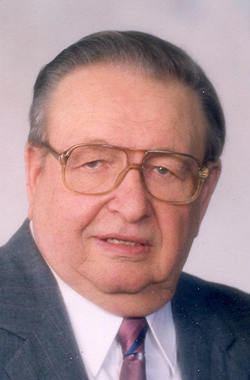
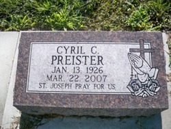
Cyril Charles Preister
| Birth | : | 13 Jan 1926 Platte County, Nebraska, USA |
| Death | : | 22 Mar 2007 Columbus, Platte County, Nebraska, USA |
| Burial | : | Scotforth Cemetery, Scotforth, City of Lancaster, England |
| Coordinate | : | 54.0282250, -2.8007170 |
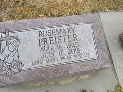
| Description | : | Son of Joseph & Clara (Magsman) Preister. He grew up on the family farm near Cornlea where he attended school. He married Rosemary Zuerlein on January 23, 1946 in Humphrey. Cyril farmed near Cornlea until 1963 when he moved to Columbus. He then worked for Gerhold Concrete for 25 years driving a ready-mix concrete truck until retiring in 1989. He was a member of St. Isidore Church and the Holy Name Society. After retirement he enjoyed woodworking, gardening, flowers, spending time at the lake cabin, fishing, boating, riding the 4-wheeler and playing with the grandchildren. Cyril is survived by: Wife: Rosemary Preister of... Read More |
frequently asked questions (FAQ):
-
Where is Cyril Charles Preister's memorial?
Cyril Charles Preister's memorial is located at: Scotforth Cemetery, Scotforth, City of Lancaster, England.
-
When did Cyril Charles Preister death?
Cyril Charles Preister death on 22 Mar 2007 in Columbus, Platte County, Nebraska, USA
-
Where are the coordinates of the Cyril Charles Preister's memorial?
Latitude: 54.0282250
Longitude: -2.8007170
Family Members:
Parent
Spouse
Siblings
Flowers:
Nearby Cemetories:
1. Scotforth Cemetery
Scotforth, City of Lancaster, England
Coordinate: 54.0282250, -2.8007170
2. Mount Street Congregational Chapel
Lancaster, City of Lancaster, England
Coordinate: 54.0468260, -2.8027430
3. Cathedral Cemetery of Lancaster
Lancaster, City of Lancaster, England
Coordinate: 54.0471170, -2.7942920
4. Friends Meeting House Burial Ground
Lancaster, City of Lancaster, England
Coordinate: 54.0482500, -2.8058025
5. St. Nicholas Street Chapel Churchyard
Lancaster, City of Lancaster, England
Coordinate: 54.0486900, -2.7987900
6. Lancaster Castle Cemetery
Lancaster, City of Lancaster, England
Coordinate: 54.0494330, -2.8047890
7. St. John the Evangelist Churchyard
Lancaster, City of Lancaster, England
Coordinate: 54.0504000, -2.7990000
8. Lancaster Priory
Lancaster, City of Lancaster, England
Coordinate: 54.0507360, -2.8057850
9. Lancaster Cemetery
Lancaster, City of Lancaster, England
Coordinate: 54.0504210, -2.7768760
10. Saint Luke's Parish Churchyard
Skerton, City of Lancaster, England
Coordinate: 54.0564700, -2.7982600
11. St John’s Church Graveyard
Ellel, City of Lancaster, England
Coordinate: 53.9990010, -2.7846660
12. St. Helen's Churchyard
Overton, City of Lancaster, England
Coordinate: 54.0111620, -2.8552950
13. Skerton Cemetery
Lancaster, City of Lancaster, England
Coordinate: 54.0651430, -2.7951140
14. Quernmore Methodist Churchyard
Quernmore, City of Lancaster, England
Coordinate: 54.0259440, -2.7361400
15. St Peter's Churchyard
Quernmore, City of Lancaster, England
Coordinate: 54.0367200, -2.7375400
16. Lancaster and Morecambe Crematorium
Lancaster, City of Lancaster, England
Coordinate: 54.0650890, -2.8198420
17. Christ Church of Glasson Churchyard
Glasson, City of Lancaster, England
Coordinate: 53.9966870, -2.8421460
18. Torrisholme Cemetery
Morecambe, City of Lancaster, England
Coordinate: 54.0638980, -2.8409800
19. St Thomas with Elizabeth Churchyard
Thurnham, City of Lancaster, England
Coordinate: 53.9819990, -2.8159520
20. St Wilfrid's Churchyard
Halton, City of Lancaster, England
Coordinate: 54.0759400, -2.7672600
21. St. Mary's Chapel Ellel Grange
Ellel, City of Lancaster, England
Coordinate: 53.9756944, -2.7918522
22. Hale Carr Lane Cemetery
Morecambe, City of Lancaster, England
Coordinate: 54.0520500, -2.8833940
23. Holy Trinity Church Poulton-le-Sands
Morecambe, City of Lancaster, England
Coordinate: 54.0744769, -2.8569331
24. Morecambe Cemetery
Morecambe, City of Lancaster, England
Coordinate: 54.0759090, -2.8572610


