
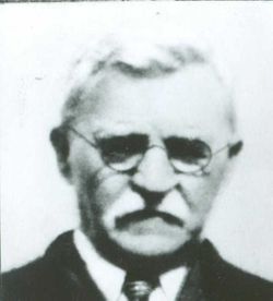
| Birth | : | 24 Oct 1834 Whitley County, Kentucky, USA |
| Death | : | 2 Feb 1918 McClelland, Pottawattamie County, Iowa, USA |
| Burial | : | Fairview Cemetery, Council Bluffs, Pottawattamie County, USA |
| Coordinate | : | 41.2703018, -95.8480988 |
| Plot | : | Sec. F lot 217 |
| Description | : | Source: Pottawattamie County Historical Society publications of 1994, book #4 pg. 62. No stone indicated nor located. Obit From http://genealogytrails.com/iowa/pottawattamie/reynolds.d1918.htm : Apoplexy caused the death early Sunday morning of Daniel Reynolds, aged 83 years, at the home of his son, J.F. Reynolds, 1620 Avenue B. He was a retired farmer. Three sons and three daughters survive. They are: J.F. and D.B. of Council Bluffs, B.J. of Plattsmouth, Mrs. W.G. Massberger of Missouri, Mrs. R.A. Bougler of Wichita, Kansas and Mrs. Alice McQuarter of Iola, Kansas. Council Bluffs Daily Nonpareil, Monday, February 4, 1918, page 7 Daniel Reynolds--Funeral The funeral of Daniel Reynolds who died February 1,... Read More |
frequently asked questions (FAQ):
-
Where is Daniel Reynolds's memorial?
Daniel Reynolds's memorial is located at: Fairview Cemetery, Council Bluffs, Pottawattamie County, USA.
-
When did Daniel Reynolds death?
Daniel Reynolds death on 2 Feb 1918 in McClelland, Pottawattamie County, Iowa, USA
-
Where are the coordinates of the Daniel Reynolds's memorial?
Latitude: 41.2703018
Longitude: -95.8480988
Family Members:
Parent
Spouse

Siblings
Children
Flowers:


Nearby Cemetories:
1. Fairview Cemetery
Council Bluffs, Pottawattamie County, USA
Coordinate: 41.2703018, -95.8480988
2. Ridgewood Cemetery
Council Bluffs, Pottawattamie County, USA
Coordinate: 41.2694016, -95.8272018
3. Walnut Hill Cemetery
Council Bluffs, Pottawattamie County, USA
Coordinate: 41.2719002, -95.8255997
4. Memorial Park Cemetery
Council Bluffs, Pottawattamie County, USA
Coordinate: 41.2644005, -95.8261032
5. Bikhor Cholim Cemetery
Council Bluffs, Pottawattamie County, USA
Coordinate: 41.2703670, -95.8229350
6. Oak Hill Cemetery
Council Bluffs, Pottawattamie County, USA
Coordinate: 41.2700900, -95.8226400
7. Green Valley Cemetery
Council Bluffs, Pottawattamie County, USA
Coordinate: 41.2743988, -95.8225021
8. Saint Joseph Cemetery
Council Bluffs, Pottawattamie County, USA
Coordinate: 41.2722015, -95.8208008
9. Cedar Lawn Cemetery
Council Bluffs, Pottawattamie County, USA
Coordinate: 41.2694016, -95.8182983
10. Clark Cemetery
Pottawattamie County, USA
Coordinate: 41.2551610, -95.8223390
11. Garner Cemetery
Council Bluffs, Pottawattamie County, USA
Coordinate: 41.2956161, -95.8001709
12. Maple Grove Cemetery
Council Bluffs, Pottawattamie County, USA
Coordinate: 41.2265560, -95.8187100
13. Evans Cemetery
Crescent, Pottawattamie County, USA
Coordinate: 41.3255997, -95.8368988
14. Stoker-Graybill Cemetery
Council Bluffs, Pottawattamie County, USA
Coordinate: 41.2532620, -95.7751770
15. Council Point Cemetery
Council Bluffs, Pottawattamie County, USA
Coordinate: 41.2110830, -95.8788610
16. Trinity Cathedral Columbarium
Omaha, Douglas County, USA
Coordinate: 41.2603900, -95.9393660
17. Lewis Township Cemetery
Council Bluffs, Pottawattamie County, USA
Coordinate: 41.2117004, -95.7938995
18. Gregg Cemetery
Weston, Pottawattamie County, USA
Coordinate: 41.3330000, -95.7931000
19. Prospect Hill Cemetery
Omaha, Douglas County, USA
Coordinate: 41.2780991, -95.9593964
20. Hazel Dell Cemetery
Council Bluffs, Pottawattamie County, USA
Coordinate: 41.3489723, -95.7939911
21. First Central Congregational Columbarium
Omaha, Douglas County, USA
Coordinate: 41.2563456, -95.9658365
22. Nash Chapel Crypt
Omaha, Douglas County, USA
Coordinate: 41.2665090, -95.9721790
23. Crescent Cemetery
Crescent, Pottawattamie County, USA
Coordinate: 41.3664894, -95.8566208
24. Douglas County Poor Farm Cemetery
Omaha, Douglas County, USA
Coordinate: 41.2437240, -95.9723480