
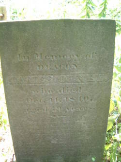
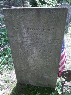
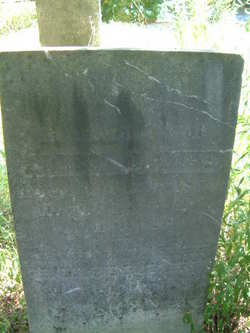
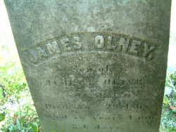
Deacon James Olney
| Birth | : | 5 Oct 1761 Providence, Providence County, Rhode Island, USA |
| Death | : | 11 Oct 1840 Johnston, Providence County, Rhode Island, USA |
| Burial | : | Fairview Cemetery, Council Bluffs, Pottawattamie County, USA |
| Coordinate | : | 41.2703018, -95.8480988 |
| Description | : | Oldest of 17 children born to Emor Olney and his 2 wives. His mother was Amey Hopkins. He served as a private in the Revolutionary War in the the company of Captain Caleb Sheldon, Colonel Atwell's Regiment. He married Olive Belknap on June 6, 1784 and would have 8 children. |
frequently asked questions (FAQ):
-
Where is Deacon James Olney's memorial?
Deacon James Olney's memorial is located at: Fairview Cemetery, Council Bluffs, Pottawattamie County, USA.
-
When did Deacon James Olney death?
Deacon James Olney death on 11 Oct 1840 in Johnston, Providence County, Rhode Island, USA
-
Where are the coordinates of the Deacon James Olney's memorial?
Latitude: 41.2703018
Longitude: -95.8480988
Family Members:
Parent

Spouse
Siblings
Children
Flowers:

May you always walk in sunshine and God's love around you flow, for the happiness you gave us, no one will ever know, it broke our hearts to lose you, but you did not go alone, a part of us went with you, the day God called you home.
Left by Anonymous on 02 Mar 2011

DAR Patriot
Left by Anonymous on 08 Jul 2011


Nearby Cemetories:
1. Fairview Cemetery
Council Bluffs, Pottawattamie County, USA
Coordinate: 41.2703018, -95.8480988
2. Ridgewood Cemetery
Council Bluffs, Pottawattamie County, USA
Coordinate: 41.2694016, -95.8272018
3. Walnut Hill Cemetery
Council Bluffs, Pottawattamie County, USA
Coordinate: 41.2719002, -95.8255997
4. Memorial Park Cemetery
Council Bluffs, Pottawattamie County, USA
Coordinate: 41.2644005, -95.8261032
5. Bikhor Cholim Cemetery
Council Bluffs, Pottawattamie County, USA
Coordinate: 41.2703670, -95.8229350
6. Oak Hill Cemetery
Council Bluffs, Pottawattamie County, USA
Coordinate: 41.2700900, -95.8226400
7. Green Valley Cemetery
Council Bluffs, Pottawattamie County, USA
Coordinate: 41.2743988, -95.8225021
8. Saint Joseph Cemetery
Council Bluffs, Pottawattamie County, USA
Coordinate: 41.2722015, -95.8208008
9. Cedar Lawn Cemetery
Council Bluffs, Pottawattamie County, USA
Coordinate: 41.2694016, -95.8182983
10. Clark Cemetery
Pottawattamie County, USA
Coordinate: 41.2551610, -95.8223390
11. Garner Cemetery
Council Bluffs, Pottawattamie County, USA
Coordinate: 41.2956161, -95.8001709
12. Maple Grove Cemetery
Council Bluffs, Pottawattamie County, USA
Coordinate: 41.2265560, -95.8187100
13. Evans Cemetery
Crescent, Pottawattamie County, USA
Coordinate: 41.3255997, -95.8368988
14. Stoker-Graybill Cemetery
Council Bluffs, Pottawattamie County, USA
Coordinate: 41.2532620, -95.7751770
15. Council Point Cemetery
Council Bluffs, Pottawattamie County, USA
Coordinate: 41.2110830, -95.8788610
16. Trinity Cathedral Columbarium
Omaha, Douglas County, USA
Coordinate: 41.2603900, -95.9393660
17. Lewis Township Cemetery
Council Bluffs, Pottawattamie County, USA
Coordinate: 41.2117004, -95.7938995
18. Gregg Cemetery
Weston, Pottawattamie County, USA
Coordinate: 41.3330000, -95.7931000
19. Prospect Hill Cemetery
Omaha, Douglas County, USA
Coordinate: 41.2780991, -95.9593964
20. Hazel Dell Cemetery
Council Bluffs, Pottawattamie County, USA
Coordinate: 41.3489723, -95.7939911
21. First Central Congregational Columbarium
Omaha, Douglas County, USA
Coordinate: 41.2563456, -95.9658365
22. Nash Chapel Crypt
Omaha, Douglas County, USA
Coordinate: 41.2665090, -95.9721790
23. Crescent Cemetery
Crescent, Pottawattamie County, USA
Coordinate: 41.3664894, -95.8566208
24. Douglas County Poor Farm Cemetery
Omaha, Douglas County, USA
Coordinate: 41.2437240, -95.9723480