
| Birth | : | 14 May 1903 Massena, Cass County, Iowa, USA |
| Death | : | 14 Oct 2000 Cedar Rapids, Linn County, Iowa, USA |
| Burial | : | Southwell Minster Churchyard, Southwell, Newark and Sherwood District, England |
| Coordinate | : | 53.0735100, -0.9524500 |
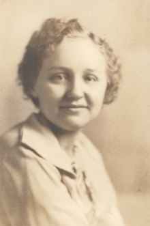
| Description | : | Della Mae Holcomb, 97, of 2115 First Ave. SE, died Saturday, October 14, 2000, in Mercy Medical Center following a long illness. Services: 1 p.m. Tuesday, Cedar Memorial Chapel of Memories. Friends may call from 4 to 7 p.m. Monday at Cedar Memorial Funeral Home. Inturnment will be at a later date. The Rev. Larry Hayward of First Presbyterian Church will officiate. Surviving, in addition to her husband, Albert, are a son, Albert and wife Rochelle of Cedar Rapids; two grandchildren, Albert and Adam; a sister, Helen Chester of Anita; and many nieces and nephews. She was... Read More |
frequently asked questions (FAQ):
-
Where is Della Mae Stender Holcomb's memorial?
Della Mae Stender Holcomb's memorial is located at: Southwell Minster Churchyard, Southwell, Newark and Sherwood District, England.
-
When did Della Mae Stender Holcomb death?
Della Mae Stender Holcomb death on 14 Oct 2000 in Cedar Rapids, Linn County, Iowa, USA
-
Where are the coordinates of the Della Mae Stender Holcomb's memorial?
Latitude: 53.0735100
Longitude: -0.9524500
Family Members:
Parent

Spouse

Siblings

Flowers:


Nearby Cemetories:
1. Southwell Minster Churchyard
Southwell, Newark and Sherwood District, England
Coordinate: 53.0735100, -0.9524500
2. St Michael the Archangel Churchyard
Halam, Newark and Sherwood District, England
Coordinate: 53.0822150, -0.9891350
3. St Denis Churchyard
Morton, Newark and Sherwood District, England
Coordinate: 53.0545100, -0.9168100
4. St Peter & St Paul's Churchyard
Upton, Newark and Sherwood District, England
Coordinate: 53.0805800, -0.9014900
5. Holy Trinity Churchyard
Rolleston, Newark and Sherwood District, England
Coordinate: 53.0646500, -0.8944500
6. St Mary's Churchyard
Bleasby, Newark and Sherwood District, England
Coordinate: 53.0386900, -0.9310700
7. St Giles Churchyard
Edingley, Newark and Sherwood District, England
Coordinate: 53.0958400, -1.0082600
8. St Swithin Churchyard
Kirklington, Newark and Sherwood District, England
Coordinate: 53.1113200, -0.9868040
9. St Oswald Churchyard
East Stoke, Newark and Sherwood District, England
Coordinate: 53.0427727, -0.8860863
10. St Laurence's Churchyard
Gonalston, Newark and Sherwood District, England
Coordinate: 53.0201000, -0.9845830
11. St Michael Churchyard
Farnsfield, Newark and Sherwood District, England
Coordinate: 53.1021600, -1.0363990
12. St. Michael's Churchyard
Averham, Newark and Sherwood District, England
Coordinate: 53.0810080, -0.8549840
13. St Michael Churchyard
Hoveringham, Newark and Sherwood District, England
Coordinate: 53.0124370, -0.9603240
14. Farndon Municipal Cemetery
Farndon, Newark and Sherwood District, England
Coordinate: 53.0606540, -0.8487310
15. St Laurence Churchyard
Thorpe, Newark and Sherwood District, England
Coordinate: 53.0428100, -0.8575900
16. St Radegund Churchyard
Maplebeck, Newark and Sherwood District, England
Coordinate: 53.1390300, -0.9385800
17. St Wilfrid's Churchyard
Kelham, Newark and Sherwood District, England
Coordinate: 53.0901100, -0.8459700
18. All Saints Churchyard
Syerston, Newark and Sherwood District, England
Coordinate: 53.0194600, -0.8884800
19. St Peter and St Paul Churchyard
Oxton, Newark and Sherwood District, England
Coordinate: 53.0560880, -1.0613440
20. Lowdham Saint Mary Churchyard Extension
Lowdham, Newark and Sherwood District, England
Coordinate: 53.0143500, -1.0125800
21. St Mary the Virgin Churchyard
Lowdham, Newark and Sherwood District, England
Coordinate: 53.0146670, -1.0135510
22. All Saints Churchyard
Elston, Newark and Sherwood District, England
Coordinate: 53.0237280, -0.8701810
23. St Andrew Churchyard
Caunton, Newark and Sherwood District, England
Coordinate: 53.1322090, -0.8869640
24. All Saints Churchyard
Hawton, Newark and Sherwood District, England
Coordinate: 53.0513890, -0.8258330