
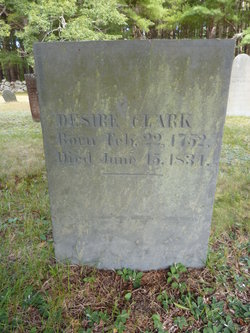
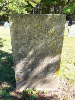
Desire Howes Clark
| Birth | : | 22 Feb 1752 Dennis, Barnstable County, Massachusetts, USA |
| Death | : | 15 Jun 1834 |
| Burial | : | Evergreen Cemetery, Marion, Plymouth County, USA |
| Coordinate | : | 41.6985435, -70.7698517 |
| Description | : | Birth date in the Dennis, MA register is Feb. 11, 1752. Married to James Clark on Dec. 10, 1772 in Harwich, MA. |
frequently asked questions (FAQ):
-
Where is Desire Howes Clark's memorial?
Desire Howes Clark's memorial is located at: Evergreen Cemetery, Marion, Plymouth County, USA.
-
When did Desire Howes Clark death?
Desire Howes Clark death on 15 Jun 1834 in
-
Where are the coordinates of the Desire Howes Clark's memorial?
Latitude: 41.6985435
Longitude: -70.7698517
Family Members:
Parent
Spouse
Siblings
Children

Flowers:


Nearby Cemetories:
1. Evergreen Cemetery
Marion, Plymouth County, USA
Coordinate: 41.6985435, -70.7698517
2. Saint Gabriels Episcopal Memorial Garden
Marion, Plymouth County, USA
Coordinate: 41.7020200, -70.7626500
3. Old Landing Cemetery
Marion, Plymouth County, USA
Coordinate: 41.7103004, -70.7707977
4. Little Neck Cemetery
Marion, Plymouth County, USA
Coordinate: 41.7175200, -70.7624900
5. Blankenship Cemetery
Marion, Plymouth County, USA
Coordinate: 41.7076200, -70.7392100
6. Point Road Memorial Forest
Marion, Plymouth County, USA
Coordinate: 41.7071400, -70.7385050
7. Friends Burial Ground
Marion, Plymouth County, USA
Coordinate: 41.7279129, -70.7757416
8. North Marion Cemetery
Marion, Plymouth County, USA
Coordinate: 41.7280884, -70.7763062
9. Friends Cemetery
Mattapoisett, Plymouth County, USA
Coordinate: 41.6658110, -70.7838390
10. Pine Island Cemetery
Mattapoisett, Plymouth County, USA
Coordinate: 41.6624947, -70.7928925
11. Saint Anthonys Cemetery
Mattapoisett, Plymouth County, USA
Coordinate: 41.6781060, -70.8271560
12. Center Cemetery
Rochester, Plymouth County, USA
Coordinate: 41.7301530, -70.8185830
13. Barlow Cemetery
Mattapoisett, Plymouth County, USA
Coordinate: 41.6641045, -70.8232269
14. Ellis Family Burial Ground
Rochester, Plymouth County, USA
Coordinate: 41.7105620, -70.8397580
15. Perry Family Cemetery
Rochester, Plymouth County, USA
Coordinate: 41.7501840, -70.7914780
16. Cushing Cemetery
Mattapoisett, Plymouth County, USA
Coordinate: 41.6624985, -70.8255997
17. Hammond Cemetery
Mattapoisett, Plymouth County, USA
Coordinate: 41.6638300, -70.8351500
18. Ellis Cemetery
Mattapoisett, Plymouth County, USA
Coordinate: 41.6957817, -70.8545609
19. Union Cemetery
Rochester, Plymouth County, USA
Coordinate: 41.7573640, -70.8202030
20. Howse Family Burial Ground
Rochester, Plymouth County, USA
Coordinate: 41.7262300, -70.8632760
21. Tobey-Fearing-Bliss Cemetery (Defunct)
Wareham, Plymouth County, USA
Coordinate: 41.7722600, -70.7464100
22. Agawam Cemetery
Wareham, Plymouth County, USA
Coordinate: 41.7463989, -70.6908035
23. Hillside Cemetery
Rochester, Plymouth County, USA
Coordinate: 41.7750015, -70.7889023
24. Saint Patricks Cemetery
Wareham, Plymouth County, USA
Coordinate: 41.7703018, -70.7264023