

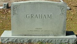
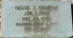
Dessie Z Graham
| Birth | : | 2 Apr 1895 |
| Death | : | 23 Dec 1956 |
| Burial | : | St. James' Churchyard, Nayland, Babergh District, England |
| Coordinate | : | 51.9715440, 0.8748140 |
frequently asked questions (FAQ):
-
Where is Dessie Z Graham's memorial?
Dessie Z Graham's memorial is located at: St. James' Churchyard, Nayland, Babergh District, England.
-
When did Dessie Z Graham death?
Dessie Z Graham death on 23 Dec 1956 in
-
Where are the coordinates of the Dessie Z Graham's memorial?
Latitude: 51.9715440
Longitude: 0.8748140
Family Members:
Parent

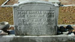
Spouse
Siblings
Children
Flowers:


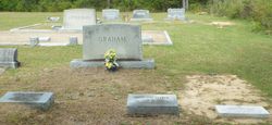
Nearby Cemetories:
1. St. James' Churchyard
Nayland, Babergh District, England
Coordinate: 51.9715440, 0.8748140
2. Nayland Cemetery
Nayland, Babergh District, England
Coordinate: 51.9735000, 0.8677410
3. All Saints Churchyard
Great Horkesley, Colchester Borough, England
Coordinate: 51.9550190, 0.8672580
4. St. Mary the Virgin Churchyard
Wissington, Babergh District, England
Coordinate: 51.9634930, 0.8436940
5. Saint Mary Churchyard
Stoke by Nayland, Babergh District, England
Coordinate: 51.9895000, 0.8925210
6. Saint Peters Churchyard
Boxted, Colchester Borough, England
Coordinate: 51.9617380, 0.9072480
7. St. Peter and St. Paul's Churchyard
Little Horkesley, Colchester Borough, England
Coordinate: 51.9516000, 0.8517000
8. St Mary Churchyard
Polstead, Babergh District, England
Coordinate: 52.0054860, 0.8964940
9. St Andrew Churchyard
Wormingford, Colchester Borough, England
Coordinate: 51.9551000, 0.8115000
10. Our Lady Immaculate Withermarsh Green
Stoke by Nayland, Babergh District, England
Coordinate: 51.9950800, 0.9326260
11. Chapel of St. Stephen
Bures St Mary, Babergh District, England
Coordinate: 51.9753000, 0.7907000
12. St Mary the Virgin Churchyard
Langham, Colchester Borough, England
Coordinate: 51.9644450, 0.9596300
13. St Edmund King and Martyr Churchyard
Assington, Babergh District, England
Coordinate: 52.0138120, 0.8194260
14. World War I Memorial
Assington, Babergh District, England
Coordinate: 52.0138200, 0.8193504
15. St Mary's Church Burial Ground
Higham, Forest Heath District, England
Coordinate: 51.9782680, 0.9626690
16. Boxford Cemetery
Boxford, Babergh District, England
Coordinate: 52.0268400, 0.8601300
17. St Mary's Churchyard
Boxford, Babergh District, England
Coordinate: 52.0280870, 0.8594160
18. St. Mary the Virgin Church
West Bergholt, Colchester Borough, England
Coordinate: 51.9143650, 0.8501530
19. Bures Baptist Chapel Chapelyard
Bures St Mary, Babergh District, England
Coordinate: 51.9730130, 0.7763930
20. West Bergholt Methodist Churchyard
West Bergholt, Colchester Borough, England
Coordinate: 51.9123993, 0.8507000
21. Bures Cemetery
Bures St Mary, Babergh District, England
Coordinate: 51.9786420, 0.7754800
22. St Michael's churchyard
Colchester Borough, England
Coordinate: 51.9107874, 0.8918244
23. St. Mary the Virgin Churchyard
Bures St Mary, Babergh District, England
Coordinate: 51.9719370, 0.7746110
24. St John the Baptist Churchyard
Mount Bures, Colchester Borough, England
Coordinate: 51.9581450, 0.7705560