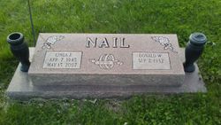
Donald Wayne Nail
| Birth | : | 2 Sep 1932 Oklahoma, USA |
| Death | : | 11 May 2013 North Kansas City, Clay County, Missouri, USA |
| Burial | : | Union Baptist Cemetery, Orrick, Ray County, USA |
| Coordinate | : | 39.2507133, -94.1969070 |
| Description | : | Donald Wayne Nail, 80, of Orrick, Mo., passed away Saturday, May 11, 2013 at North Kansas City Hospice House. Donald was born on September 2, 1932 in Northern Oklahoma, the son of Ellis and Maple (Collier) Nail. He was an avid runner in multiple marathons. Donald worked and retired from Lake City Ammunition Plant, where he worked for 30 plus years. He received the Masonic 50 year pin. He loved working on his farm, raising cattle and enjoyed his grandchildren. Donald is survived by his daughter, Joan Lichty; two sons, Steve Nail and David Nail and his wife, Christie; two stepsons, Tony... Read More |
frequently asked questions (FAQ):
-
Where is Donald Wayne Nail's memorial?
Donald Wayne Nail's memorial is located at: Union Baptist Cemetery, Orrick, Ray County, USA.
-
When did Donald Wayne Nail death?
Donald Wayne Nail death on 11 May 2013 in North Kansas City, Clay County, Missouri, USA
-
Where are the coordinates of the Donald Wayne Nail's memorial?
Latitude: 39.2507133
Longitude: -94.1969070
Family Members:
Spouse
Children
Flowers:
Nearby Cemetories:
1. Union Baptist Cemetery
Orrick, Ray County, USA
Coordinate: 39.2507133, -94.1969070
2. Old Allen Cemetery
Ray County, USA
Coordinate: 39.2433281, -94.1977005
3. Bogart Family Cemetery
Ray County, USA
Coordinate: 39.2644400, -94.1777800
4. Elitzer Cemetery
Miltondale, Clay County, USA
Coordinate: 39.2595640, -94.2289210
5. Riffe Cemetery
Orrick, Ray County, USA
Coordinate: 39.2514000, -94.1492004
6. Siegel Cemetery
Excelsior Springs, Ray County, USA
Coordinate: 39.2943993, -94.1977997
7. Moore Cemetery
Excelsior Springs, Clay County, USA
Coordinate: 39.2696991, -94.2530975
8. Scott Cemetery
Clay County, USA
Coordinate: 39.2708015, -94.2538986
9. Rowland Cemetery
Ray County, USA
Coordinate: 39.2694016, -94.1389008
10. Enon Cemetery
Excelsior Springs, Clay County, USA
Coordinate: 39.2958984, -94.2221985
11. Oldham Cemetery
Sibley, Jackson County, USA
Coordinate: 39.2037500, -94.2261400
12. Dixon Family Cemetery
Fort Osage Township, Jackson County, USA
Coordinate: 39.1965120, -94.2247932
13. Tucker-Gryder Cemetery
Richmond, Ray County, USA
Coordinate: 39.2411800, -94.1198700
14. Stokes Cemetery
Ray County, USA
Coordinate: 39.2270600, -94.1225900
15. Old Albany Cemetery
Orrick, Ray County, USA
Coordinate: 39.2265885, -94.1210713
16. Sibley Cemetery
Sibley, Jackson County, USA
Coordinate: 39.1853981, -94.1940994
17. O'Dell Cemetery
Excelsior Springs, Ray County, USA
Coordinate: 39.2995987, -94.1346970
18. Rock Falls Church Cemetery
Elkhorn, Ray County, USA
Coordinate: 39.2893500, -94.1221800
19. Old New Garden Primitive Baptist Cemetery
Wood Heights, Ray County, USA
Coordinate: 39.3227005, -94.1669006
20. Missouri City Cemetery
Missouri City, Clay County, USA
Coordinate: 39.2417297, -94.2970734
21. Buxton Cemetery
Prathersville, Clay County, USA
Coordinate: 39.2780991, -94.2919006
22. North New Garden Primitive Baptist Church Cemetery
Wood Heights, Ray County, USA
Coordinate: 39.3271027, -94.1648026
23. Lewis Cemetery
Orrick, Ray County, USA
Coordinate: 39.2386017, -94.0935974
24. South Point Cemetery
Orrick, Ray County, USA
Coordinate: 39.2233009, -94.0978012


