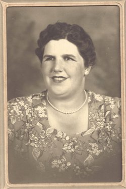
Duella Belle Witte Robertson
| Birth | : | 24 Jun 1915 Des Moines County, Iowa, USA |
| Death | : | 16 Mar 2003 Burlington, Des Moines County, Iowa, USA |
| Burial | : | York Cemetery, York, York Unitary Authority, England |
| Coordinate | : | 53.9503960, -1.0723530 |
| Description | : | The Burlington Hawkeye, March 18, 2003 Duella Robertson Duella Belle Robertson, 87, of Burlington, died at 11:30 p.m. Sunday, March 16, 2003, at her home. Born June 24, 1915, in rural Des Moines County, she was the daughter of Edward F. and Zella Wells Witte. On Oct. 11, 1934, she married Floyd A. Robertson in Galesburg, Ill. He died May 26, 1996. Mrs. Robertson was a homemaker. She was a member of Grace United Methodist Church. She also was a 50-year member of Nellie Walker King's Daughters. Survivors include four sons, Marvin Robertson and Roger Robertson, both of Winter Haven, Fla.,... Read More |
frequently asked questions (FAQ):
-
Where is Duella Belle Witte Robertson's memorial?
Duella Belle Witte Robertson's memorial is located at: York Cemetery, York, York Unitary Authority, England.
-
When did Duella Belle Witte Robertson death?
Duella Belle Witte Robertson death on 16 Mar 2003 in Burlington, Des Moines County, Iowa, USA
-
Where are the coordinates of the Duella Belle Witte Robertson's memorial?
Latitude: 53.9503960
Longitude: -1.0723530
Family Members:
Parent
Spouse
Siblings
Children
Flowers:
Nearby Cemetories:
1. York Cemetery
York, York Unitary Authority, England
Coordinate: 53.9503960, -1.0723530
2. St Helen Churchyard
York, York Unitary Authority, England
Coordinate: 53.9509330, -1.0753630
3. St. Lawrence's Churchyard
York, York Unitary Authority, England
Coordinate: 53.9540530, -1.0688730
4. St George Churchyard
York, York Unitary Authority, England
Coordinate: 53.9548420, -1.0757670
5. St Edward's-without-Walmgate (Defunct)
York, York Unitary Authority, England
Coordinate: 53.9547280, -1.0657383
6. York Castle Prison Cemetery
York, York Unitary Authority, England
Coordinate: 53.9551950, -1.0782660
7. St Margaret Churchyard
York, York Unitary Authority, England
Coordinate: 53.9565370, -1.0729530
8. St Clement Priory Churchyard (Defunct)
York, York Unitary Authority, England
Coordinate: 53.9524710, -1.0827970
9. Friends Burial Ground
York, York Unitary Authority, England
Coordinate: 53.9478920, -1.0618450
10. St Denys Churchyard
York, York Unitary Authority, England
Coordinate: 53.9567080, -1.0762240
11. Greyfriars Abbey Church (Defunct)
York, York Unitary Authority, England
Coordinate: 53.9553090, -1.0814240
12. St. Mary Castlegate Churchyard
York, York Unitary Authority, England
Coordinate: 53.9570800, -1.0804370
13. Friends Burial Ground
York, York Unitary Authority, England
Coordinate: 53.9550140, -1.0846700
14. St Clement Church
York, York Unitary Authority, England
Coordinate: 53.9511660, -1.0871720
15. St Mary Bishophill Senior Churchyard
York, York Unitary Authority, England
Coordinate: 53.9551780, -1.0849680
16. St John Churchyard
York, York Unitary Authority, England
Coordinate: 53.9591850, -1.0761680
17. All Saints Pavement Churchyard
York, York Unitary Authority, England
Coordinate: 53.9581090, -1.0808820
18. Carmelite Friary of York (Defunct)
York, York Unitary Authority, England
Coordinate: 53.9577020, -1.0822860
19. Saint Peter's
York, York Unitary Authority, England
Coordinate: 53.9577400, -1.0822600
20. St Crux Hungate Burial Ground
York, York Unitary Authority, England
Coordinate: 53.9593540, -1.0774470
21. St Michael Churchyard
York, York Unitary Authority, England
Coordinate: 53.9577900, -1.0825600
22. All Saints Peasholme (Defunct)
York, York Unitary Authority, England
Coordinate: 53.9597200, -1.0759220
23. St Crux Churchyard
York, York Unitary Authority, England
Coordinate: 53.9589890, -1.0795460
24. Central Methodist Hall
York, York Unitary Authority, England
Coordinate: 53.9594090, -1.0788330


