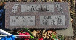
Earl Ray Tague
| Birth | : | 4 Nov 1933 Scotland County, Missouri, USA |
| Death | : | 22 Feb 1991 Gorin, Scotland County, Missouri, USA |
| Burial | : | Bracken Ridge Church Cemetery, Summit Township, Monroe County, USA |
| Coordinate | : | 39.7747960, -81.2629620 |
frequently asked questions (FAQ):
-
Where is Earl Ray Tague's memorial?
Earl Ray Tague's memorial is located at: Bracken Ridge Church Cemetery, Summit Township, Monroe County, USA.
-
When did Earl Ray Tague death?
Earl Ray Tague death on 22 Feb 1991 in Gorin, Scotland County, Missouri, USA
-
Where are the coordinates of the Earl Ray Tague's memorial?
Latitude: 39.7747960
Longitude: -81.2629620
Family Members:
Parent
Siblings
Flowers:
Nearby Cemetories:
1. Bracken Ridge Church Cemetery
Summit Township, Monroe County, USA
Coordinate: 39.7747960, -81.2629620
2. Wise Cemetery
Lewisville, Monroe County, USA
Coordinate: 39.7754620, -81.2504200
3. Saint Josephs Roman Catholic Church Cemetery
Summit Township, Monroe County, USA
Coordinate: 39.7882750, -81.2620940
4. Hamilton Cemetery
Monroe County, USA
Coordinate: 39.7810360, -81.2445330
5. Swazey Methodist Cemetery
Monroe County, USA
Coordinate: 39.7661800, -81.2887300
6. Chapel Hill Cemetery
Burkhart, Monroe County, USA
Coordinate: 39.8093987, -81.2583008
7. Friendship Cemetery
Lewisville, Monroe County, USA
Coordinate: 39.7592010, -81.2221985
8. Evangelical Reformed Church Cemetery
Lewisville, Monroe County, USA
Coordinate: 39.7625723, -81.2184446
9. Lewisville German Lutheran Cemetery
Monroe County, USA
Coordinate: 39.7625700, -81.2184400
10. Saint Johns Cemetery
Summit Township, Monroe County, USA
Coordinate: 39.8020164, -81.2159442
11. Sutherland Methodist Cemetery
Stafford, Monroe County, USA
Coordinate: 39.7281281, -81.2692804
12. Danford Cemetery
Monroe County, USA
Coordinate: 39.8119011, -81.3039017
13. Brister Cemetery
Calais, Monroe County, USA
Coordinate: 39.8257100, -81.2629900
14. Mount Zion Methodist Cemetery
Lewisville, Monroe County, USA
Coordinate: 39.7238390, -81.2483750
15. German Cemetery
Monroe County, USA
Coordinate: 39.8100014, -81.2125015
16. Eastern Cemetery
Summerfield, Noble County, USA
Coordinate: 39.8015100, -81.3316920
17. Summerfield Methodist Church Cemetery
Summerfield, Noble County, USA
Coordinate: 39.7967339, -81.3358231
18. Stafford Cemetery
Stafford, Monroe County, USA
Coordinate: 39.7128500, -81.2723400
19. Curtis Ridge Cemetery
Noble County, USA
Coordinate: 39.7546997, -81.3419037
20. Buchanan Presbyterian Church Cemetery
Summit Township, Monroe County, USA
Coordinate: 39.7678490, -81.1798325
21. Crow Cemetery
Carlisle, Noble County, USA
Coordinate: 39.7651500, -81.3469770
22. Mount Tabor Cemetery
Carlisle, Noble County, USA
Coordinate: 39.7220001, -81.3229980
23. Aaron Cemetery
Calais, Monroe County, USA
Coordinate: 39.8417015, -81.2936020
24. Calais Cemetery
Seneca Township, Monroe County, USA
Coordinate: 39.8489000, -81.2753000

