
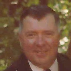
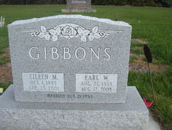
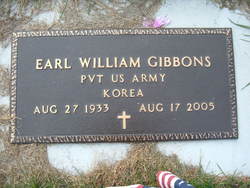
Earl William Gibbons
| Birth | : | 27 Aug 1933 McLeod, Ransom County, North Dakota, USA |
| Death | : | 17 Aug 2005 Enderlin, Ransom County, North Dakota, USA |
| Burial | : | North Watford Cemetery, Watford, Watford Borough, England |
| Coordinate | : | 51.6832680, -0.4033640 |
| Inscription | : | PVT US Army Korea |
| Description | : | Earl W. Gibbons, 71, Fingal, died Wednesday, Aug. 17, 2005, in Maryhill Manor, Enderlin, N.D. Mr. Gibbons was born Aug. 27, 1933, near McLeod, N.D. He attended school in Leonard, N.D. He served from 1953 to 1955 in the U.S. Army during the Korean War. On Oct. 21, 1953, he married Eileen Mae Lemke in Enderlin. They lived in Enderlin, where he worked for the railroad. In 1959, they moved to West Fargo. He worked for the Veterans Affairs Medical Center, Fargo, and also as an auctioneer. In 1967, they moved to Fargo. He retired in 1988.... Read More |
frequently asked questions (FAQ):
-
Where is Earl William Gibbons's memorial?
Earl William Gibbons's memorial is located at: North Watford Cemetery, Watford, Watford Borough, England.
-
When did Earl William Gibbons death?
Earl William Gibbons death on 17 Aug 2005 in Enderlin, Ransom County, North Dakota, USA
-
Where are the coordinates of the Earl William Gibbons's memorial?
Latitude: 51.6832680
Longitude: -0.4033640
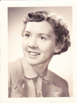
Family Members:
Parent
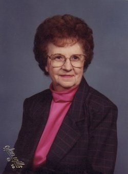
Spouse
Flowers:


Nearby Cemetories:
1. North Watford Cemetery
Watford, Watford Borough, England
Coordinate: 51.6832680, -0.4033640
2. All Saints Churchyard
Watford Borough, England
Coordinate: 51.6954810, -0.3885560
3. West Herts Crematorium
Watford, Watford Borough, England
Coordinate: 51.7004195, -0.3847509
4. St. Paul Churchyard
Kings Langley, Dacorum Borough, England
Coordinate: 51.6931700, -0.4383900
5. East Lane Cemetery
Leavesden, Three Rivers District, England
Coordinate: 51.7084796, -0.4036263
6. St Lawrence the Martyr Churchyard
Abbots Langley, Three Rivers District, England
Coordinate: 51.7077650, -0.4170030
7. St. Mary's Churchyard
Watford, Watford Borough, England
Coordinate: 51.6546240, -0.3958510
8. Vicarage Road Cemetery
Watford, Watford Borough, England
Coordinate: 51.6517850, -0.4008620
9. St. John the Baptist Churchyard
Aldenham, Hertsmere Borough, England
Coordinate: 51.6734130, -0.3531610
10. Sir David Yule Mausoleum
St Albans, St Albans District, England
Coordinate: 51.7024660, -0.3505190
11. Bushey Jewish Cemetery
Bushey, Watford Borough, England
Coordinate: 51.6580150, -0.3572810
12. All Saints Churchyard
Kings Langley, Dacorum Borough, England
Coordinate: 51.7109030, -0.4479280
13. St. James' Churchyard
Bushey, Watford Borough, England
Coordinate: 51.6443700, -0.3679250
14. Kings Langley Priory
Kings Langley, Dacorum Borough, England
Coordinate: 51.7130000, -0.4603000
15. Bushey United Reformed Congregational Churchyard
Bushey, Watford Borough, England
Coordinate: 51.6440000, -0.3611200
16. Christ Church
Radlett, Hertsmere Borough, England
Coordinate: 51.6802460, -0.3163610
17. Holy Trinity Churchyard
St Albans, St Albans District, England
Coordinate: 51.7170354, -0.3334244
18. Frogmore Holy Trinity Burial Ground
St Albans District, England
Coordinate: 51.7197598, -0.3365342
19. Oxhey Chapel Burial Ground
Three Rivers District, England
Coordinate: 51.6279000, -0.3927500
20. Chorleywood Road Cemetery
Rickmansworth, Three Rivers District, England
Coordinate: 51.6440320, -0.4753040
21. Church of the Holy Cross Churchyard
Sarratt, Three Rivers District, England
Coordinate: 51.6747100, -0.4991540
22. Carpenders Park Lawn Cemetery
Watford, Watford Borough, England
Coordinate: 51.6258920, -0.3707550
23. St Mary's Church Apsley End
Apsley, Dacorum Borough, England
Coordinate: 51.7347710, -0.4659480
24. Holy Trinity Churchyard
Leverstock Green, Dacorum Borough, England
Coordinate: 51.7466800, -0.4295770