
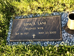
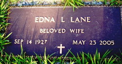
Edna L Eygabroad Lane
| Birth | : | 14 Sep 1927 |
| Death | : | 23 May 2005 |
| Burial | : | Downside Cemetery, Chilcompton, Mendip District, England |
| Coordinate | : | 51.2517300, -2.5152400 |
frequently asked questions (FAQ):
-
Where is Edna L Eygabroad Lane's memorial?
Edna L Eygabroad Lane's memorial is located at: Downside Cemetery, Chilcompton, Mendip District, England.
-
When did Edna L Eygabroad Lane death?
Edna L Eygabroad Lane death on 23 May 2005 in
-
Where are the coordinates of the Edna L Eygabroad Lane's memorial?
Latitude: 51.2517300
Longitude: -2.5152400
Family Members:
Parent
Spouse
Siblings

Children
Flowers:


Nearby Cemetories:
1. Downside Cemetery
Chilcompton, Mendip District, England
Coordinate: 51.2517300, -2.5152400
2. Christ Church, Downside
Chilcompton, Mendip District, England
Coordinate: 51.2515150, -2.5153030
3. Christ Church Churchyard
Mendip District, England
Coordinate: 51.2514920, -2.5151540
4. Downside Abbey
Stratton-on-the-Fosse, Mendip District, England
Coordinate: 51.2544000, -2.4943000
5. St. Benedict's Churchyard
Stratton-on-the-Fosse, Mendip District, England
Coordinate: 51.2560684, -2.4913545
6. Saint Vigor Churchyard
Stratton-on-the-Fosse, Mendip District, England
Coordinate: 51.2552000, -2.4896000
7. St John the Baptist Church Cemetery
Chilcompton, Mendip District, England
Coordinate: 51.2693960, -2.5073780
8. St James Churchyard
Ashwick, Mendip District, England
Coordinate: 51.2320800, -2.5229500
9. St. Andrew's Churchyard
Holcombe, Mendip District, England
Coordinate: 51.2547850, -2.4760280
10. Holy Trinity Churchyard
Binegar, Mendip District, England
Coordinate: 51.2425530, -2.5524812
11. St. Mary the Virgin Churchyard
Emborough, Mendip District, England
Coordinate: 51.2600970, -2.5539150
12. St Mary The Virgin Churchyard
Ston Easton, Mendip District, England
Coordinate: 51.2788400, -2.5404390
13. Saint Mary the Virgin Church
Ston Easton, Mendip District, England
Coordinate: 51.2789610, -2.5407720
14. St Michael & All Angels
Stoke St Michael, Mendip District, England
Coordinate: 51.2208300, -2.4819900
15. St. John the Baptist Churchyard
Midsomer Norton, Bath and North East Somerset Unitary Authority, England
Coordinate: 51.2870310, -2.4842190
16. Holy Trinity Churchyard
Coleford, Mendip District, England
Coordinate: 51.2394100, -2.4503100
17. St Mary Magdalene Churchyard
Chewton Mendip, Mendip District, England
Coordinate: 51.2760790, -2.5800490
18. St. John the Baptist Churchyard
Farrington Gurney, Bath and North East Somerset Unitary Authority, England
Coordinate: 51.2993710, -2.5248000
19. St Peter and St Paul Churchyard
Kilmersdon, Mendip District, England
Coordinate: 51.2701480, -2.4372860
20. Saint Giles Churchyard
Leigh-on-Mendip, Mendip District, England
Coordinate: 51.2239000, -2.4416000
21. Church of the Holy Trinity
Paulton, Bath and North East Somerset Unitary Authority, England
Coordinate: 51.3074740, -2.5033500
22. St. Nicholas' Churchyard
Radstock, Bath and North East Somerset Unitary Authority, England
Coordinate: 51.2900740, -2.4488510
23. St. Margaret's Churchyard
Frome, Mendip District, England
Coordinate: 51.2576670, -2.4242260
24. Saint Mary the Virgin Churchyard
Litton, Mendip District, England
Coordinate: 51.2899860, -2.5838440