


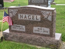
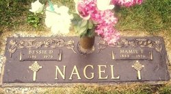
Edward A Nagel
| Birth | : | Mar 1893 Ohio, USA |
| Death | : | 1974 |
| Burial | : | St Peter and St Paul Churchyard, Oxton, Newark and Sherwood District, England |
| Coordinate | : | 53.0560880, -1.0613440 |
| Plot | : | Lot 132 Plt B |
| Description | : | s/o William & Mary Nagel |
frequently asked questions (FAQ):
-
Where is Edward A Nagel's memorial?
Edward A Nagel's memorial is located at: St Peter and St Paul Churchyard, Oxton, Newark and Sherwood District, England.
-
When did Edward A Nagel death?
Edward A Nagel death on 1974 in
-
Where are the coordinates of the Edward A Nagel's memorial?
Latitude: 53.0560880
Longitude: -1.0613440
Family Members:
Parent
Spouse
Siblings


Children

Flowers:


Nearby Cemetories:
1. St Peter and St Paul Churchyard
Oxton, Newark and Sherwood District, England
Coordinate: 53.0560880, -1.0613440
2. Tithe Green Burial Ground
Calverton, Gedling Borough, England
Coordinate: 53.0672540, -1.0949290
3. Woodborough Cemetery
Woodborough, Gedling Borough, England
Coordinate: 53.0272840, -1.0600540
4. St Michael Churchyard
Farnsfield, Newark and Sherwood District, England
Coordinate: 53.1021600, -1.0363990
5. St Mary the Virgin Churchyard
Lowdham, Newark and Sherwood District, England
Coordinate: 53.0146670, -1.0135510
6. St Michael the Archangel Churchyard
Halam, Newark and Sherwood District, England
Coordinate: 53.0822150, -0.9891350
7. St Giles Churchyard
Edingley, Newark and Sherwood District, England
Coordinate: 53.0958400, -1.0082600
8. Lowdham Saint Mary Churchyard Extension
Lowdham, Newark and Sherwood District, England
Coordinate: 53.0143500, -1.0125800
9. St Mary of the Purification Churchyard
Blidworth, Newark and Sherwood District, England
Coordinate: 53.0946620, -1.1269380
10. St Laurence's Churchyard
Gonalston, Newark and Sherwood District, England
Coordinate: 53.0201000, -0.9845830
11. Redhill Cemetery
Arnold, Nottingham Unitary Authority, England
Coordinate: 53.0066910, -1.1382950
12. Southwell Minster Churchyard
Southwell, Newark and Sherwood District, England
Coordinate: 53.0735100, -0.9524500
13. St. Helen's Churchyard
Burton Joyce, Gedling Borough, England
Coordinate: 52.9866700, -1.0365400
14. St Swithin Churchyard
Kirklington, Newark and Sherwood District, England
Coordinate: 53.1113200, -0.9868040
15. Burton Joyce Cemetery
Burton Joyce, Gedling Borough, England
Coordinate: 52.9863100, -1.0370710
16. St Michael Churchyard
Hoveringham, Newark and Sherwood District, England
Coordinate: 53.0124370, -0.9603240
17. St. James Churchyard
Papplewick, Gedling Borough, England
Coordinate: 53.0582060, -1.1872990
18. Gedling Cemetery
Gedling, Gedling Borough, England
Coordinate: 52.9806930, -1.0870670
19. St John the Baptist Gunthorpe
Gunthorpe, Newark and Sherwood District, England
Coordinate: 52.9925600, -0.9877400
20. All Hallows Churchyard
Gedling, Gedling Borough, England
Coordinate: 52.9769400, -1.0805130
21. St Mary's Churchyard
Bleasby, Newark and Sherwood District, England
Coordinate: 53.0386900, -0.9310700
22. Shelford Priory
Shelford, Rushcliffe Borough, England
Coordinate: 52.9830600, -0.9994100
23. Newstead Abbey
Newstead, Gedling Borough, England
Coordinate: 53.0783450, -1.1931120
24. SS Peter & Paul Churchyard
Shelford, Rushcliffe Borough, England
Coordinate: 52.9745600, -1.0161200