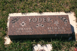
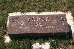
Edward John “Ed” Yoder
| Birth | : | 19 Mar 1915 Roslyn, Day County, South Dakota, USA |
| Death | : | 1 Jan 2006 Spearfish, Lawrence County, South Dakota, USA |
| Burial | : | St John the Evangelist Churchyard, Hildenborough, Tonbridge and Malling Borough, England |
| Coordinate | : | 51.2174100, 0.2391660 |
| Description | : | Edward “Ed” John Yoder, Spearfish, died Sunday, Jan. 1, 2006, at the Dorsett Health Care Facility in Spearfish. Visitation was from 8 a.m. to 9 p.m. on Friday at the Kinkade Funeral Chapel in Sturgis and one hour prior to services at the church on Saturday. Funeral services will be 10 a.m. Saturday, Jan. 7, 2006 at the Christian Fellowship Church in Newell, with Pastor Sean Carney officiating. Burial will follow with Masonic Graveside Rites at the Hope Cemetery in Newell. Ed was born March 19, 1915 at Roslyn, to Martin and Anna Sattler. At an early... Read More |
frequently asked questions (FAQ):
-
Where is Edward John “Ed” Yoder's memorial?
Edward John “Ed” Yoder's memorial is located at: St John the Evangelist Churchyard, Hildenborough, Tonbridge and Malling Borough, England.
-
When did Edward John “Ed” Yoder death?
Edward John “Ed” Yoder death on 1 Jan 2006 in Spearfish, Lawrence County, South Dakota, USA
-
Where are the coordinates of the Edward John “Ed” Yoder's memorial?
Latitude: 51.2174100
Longitude: 0.2391660
Family Members:
Parent
Spouse
Flowers:
Nearby Cemetories:
1. St John the Evangelist Churchyard
Hildenborough, Tonbridge and Malling Borough, England
Coordinate: 51.2174100, 0.2391660
2. Hildenborough War Memorial
Hildenborough, Tonbridge and Malling Borough, England
Coordinate: 51.2175827, 0.2372410
3. St. Mary's Churchyard
Leigh, Sevenoaks District, England
Coordinate: 51.1977660, 0.2151510
4. Tonbridge Cemetery
Tonbridge, Tonbridge and Malling Borough, England
Coordinate: 51.2057762, 0.2772440
5. St. Margaret's Churchyard
Underriver, Sevenoaks District, England
Coordinate: 51.2458191, 0.2291520
6. Tonbridge Castle
Tonbridge, Tonbridge and Malling Borough, England
Coordinate: 51.1987000, 0.2764000
7. St Peter and St Paul Church
Tonbridge, Tonbridge and Malling Borough, England
Coordinate: 51.1977660, 0.2764630
8. St Stephens
Tonbridge, Tonbridge and Malling Borough, England
Coordinate: 51.1893961, 0.2687135
9. St Giles Churchyard
Shipbourne, Tonbridge and Malling Borough, England
Coordinate: 51.2471700, 0.2786090
10. St Luke Churchyard
Chiddingstone Causeway, Sevenoaks District, England
Coordinate: 51.1974910, 0.1758540
11. Ightham Mote
Ightham, Tonbridge and Malling Borough, England
Coordinate: 51.2584610, 0.2695830
12. St. Lawrence Churchyard
Bidborough, Tunbridge Wells Borough, England
Coordinate: 51.1666950, 0.2371870
13. Southborough War Memorial
Southborough, Tunbridge Wells Borough, England
Coordinate: 51.1639214, 0.2528920
14. Plaxtol Parish Churchyard
Plaxtol, Tonbridge and Malling Borough, England
Coordinate: 51.2593498, 0.2945710
15. Plaxtol War Memorial
Plaxtol, Tonbridge and Malling Borough, England
Coordinate: 51.2592888, 0.2948450
16. St. Peter's Churchyard
Southborough, Tunbridge Wells Borough, England
Coordinate: 51.1626549, 0.2520690
17. St. John the Baptist Churchyard
Penshurst, Sevenoaks District, England
Coordinate: 51.1735240, 0.1834540
18. Holy Trinity Churchyard
Crockham Hill, Sevenoaks District, England
Coordinate: 51.1982790, 0.1538090
19. St Nicholas Churchyard
Sevenoaks, Sevenoaks District, England
Coordinate: 51.2673310, 0.1933100
20. St. Lawrence Churchyard
Seal Chart, Sevenoaks District, England
Coordinate: 51.2742910, 0.2537250
21. Southborough Cemetery
Southborough, Tunbridge Wells Borough, England
Coordinate: 51.1592860, 0.2420140
22. All Saints Churchyard
Tudeley, Tunbridge Wells Borough, England
Coordinate: 51.1848510, 0.3186970
23. Chiddingstone Churchyard Extension
Chiddingstone, Sevenoaks District, England
Coordinate: 51.1861590, 0.1488930
24. Sevenoaks War Memorial
Sevenoaks, Sevenoaks District, England
Coordinate: 51.2761078, 0.1927860


