

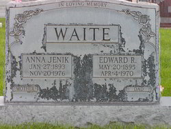
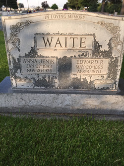
Edward Ralph Waite
| Birth | : | 20 May 1895 Woodbine, Harrison County, Iowa, USA |
| Death | : | 4 Apr 1970 Sidney, Cheyenne County, Nebraska, USA |
| Burial | : | Greenwood Cemetery, Aurelius, Ingham County, USA |
| Coordinate | : | 42.5138893, -84.5233307 |
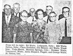
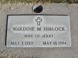
| Description | : | Edward Ralph Waite of Lodgepole was born 20 may 1895 in Woodbine, Iowa, the son of William Albert and Louisa "Lizi" (Baker) Waite. He was the fourth child of eight of this union, and the third son of five. On 14 jun 1922, he married Anna Jenik in Lodgepole. She survives. They are also survived by two children, Muriel Adelaide (Leroy) Glanz, and Wardine Marie (Gerald) Niblock, and 4 grandchildren Linda and John Glanz, and Gayland and Carol Niblock. |
frequently asked questions (FAQ):
-
Where is Edward Ralph Waite's memorial?
Edward Ralph Waite's memorial is located at: Greenwood Cemetery, Aurelius, Ingham County, USA.
-
When did Edward Ralph Waite death?
Edward Ralph Waite death on 4 Apr 1970 in Sidney, Cheyenne County, Nebraska, USA
-
Where are the coordinates of the Edward Ralph Waite's memorial?
Latitude: 42.5138893
Longitude: -84.5233307
Family Members:
Parent
Spouse
Siblings

Children

Flowers:


Nearby Cemetories:
1. Greenwood Cemetery
Aurelius, Ingham County, USA
Coordinate: 42.5138893, -84.5233307
2. Rolfe Cemetery
Mason, Ingham County, USA
Coordinate: 42.5243988, -84.4569016
3. Fowler Cemetery
Aurelius, Ingham County, USA
Coordinate: 42.5400367, -84.5822004
4. Plains Cemetery
Aurelius, Ingham County, USA
Coordinate: 42.5096200, -84.5944480
5. Lane Cemetery
Onondaga, Ingham County, USA
Coordinate: 42.4505600, -84.5358300
6. North Aurelius Cemetery
Aurelius Township, Ingham County, USA
Coordinate: 42.5818420, -84.5388130
7. Bunker Hill Cemetery
Eaton Rapids, Eaton County, USA
Coordinate: 42.5534280, -84.6042970
8. Eden Cemetery
Mason, Ingham County, USA
Coordinate: 42.5210991, -84.4191971
9. Onondaga Cemetery
Onondaga, Ingham County, USA
Coordinate: 42.4445877, -84.5699387
10. First United Methodist Church of Mason Columbarium
Mason, Ingham County, USA
Coordinate: 42.5796620, -84.4414330
11. Woodlawn Cemetery
Leslie, Ingham County, USA
Coordinate: 42.4570274, -84.4298935
12. Maple Grove Cemetery
Mason, Ingham County, USA
Coordinate: 42.5856018, -84.4458008
13. Munger Cemetery
Eaton Rapids, Eaton County, USA
Coordinate: 42.5746994, -84.6213989
14. Walker Cemetery
Rives Junction, Jackson County, USA
Coordinate: 42.4218712, -84.4820557
15. Markham Cemetery
Holt, Ingham County, USA
Coordinate: 42.6035995, -84.5819016
16. Rosehill Cemetery
Eaton Rapids, Eaton County, USA
Coordinate: 42.5003014, -84.6635971
17. Oakwood Cemetery
Eaton Rapids, Eaton County, USA
Coordinate: 42.4947014, -84.6659012
18. Hawley Cemetery
Mason, Ingham County, USA
Coordinate: 42.5508003, -84.3792038
19. Bentley Cemetery
Eaton Rapids, Eaton County, USA
Coordinate: 42.5456009, -84.6761017
20. Stewart Cemetery (Defunct)
Tompkins, Jackson County, USA
Coordinate: 42.3944321, -84.5210876
21. Rives Township Memorial Cemetery
Rives Junction, Jackson County, USA
Coordinate: 42.3993660, -84.4731100
22. Griffith Cemetery
Springport, Jackson County, USA
Coordinate: 42.4150620, -84.6215515
23. Felt Plains Cemetery
Leslie, Ingham County, USA
Coordinate: 42.4874992, -84.3585968
24. Brown Cemetery
Tompkins, Jackson County, USA
Coordinate: 42.3927765, -84.5833359