
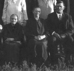

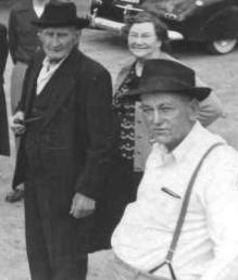
Louisa Albertina “Lizi” Baker Waite
| Birth | : | 13 Oct 1869 |
| Death | : | 2 Dec 1928 Lodgepole, Cheyenne County, Nebraska, USA |
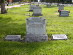
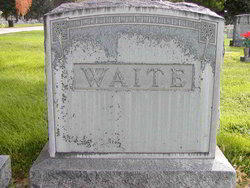
| Burial | : | Greenwood Cemetery, Aurelius, Ingham County, USA |
| Coordinate | : | 42.5138893, -84.5233307 |
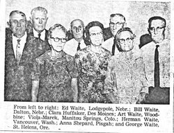
| Description | : | Louisa Albertina "Lizi" Baker was born in Ball, Prussia, Germany on October 13, 1869. She immigrated to the United States in 1882 with her mother Wilhelmina "Minnie" (Tornow) Baker and her brother William Fredrick, and her sister Amelia "Millie" (Baker) Horn. She married William Albert "Al" Waite in Woodbine, IA on February 15, 1888. They moved about in Iowa, Missouri, and Nebraska. In 1917, she and her husband moved to Lodgepole, NE where they farmed. She died in 1928 and was buried in Sidney. She and her husband were the parents of eight children Lizi and her... Read More |
frequently asked questions (FAQ):
-
Where is Louisa Albertina “Lizi” Baker Waite's memorial?
Louisa Albertina “Lizi” Baker Waite's memorial is located at: Greenwood Cemetery, Aurelius, Ingham County, USA.
-
When did Louisa Albertina “Lizi” Baker Waite death?
Louisa Albertina “Lizi” Baker Waite death on 2 Dec 1928 in Lodgepole, Cheyenne County, Nebraska, USA
-
Where are the coordinates of the Louisa Albertina “Lizi” Baker Waite's memorial?
Latitude: 42.5138893
Longitude: -84.5233307
Family Members:
Parent

Spouse
Siblings
Children

Flowers:


Nearby Cemetories:
1. Greenwood Cemetery
Aurelius, Ingham County, USA
Coordinate: 42.5138893, -84.5233307
2. Rolfe Cemetery
Mason, Ingham County, USA
Coordinate: 42.5243988, -84.4569016
3. Fowler Cemetery
Aurelius, Ingham County, USA
Coordinate: 42.5400367, -84.5822004
4. Plains Cemetery
Aurelius, Ingham County, USA
Coordinate: 42.5096200, -84.5944480
5. Lane Cemetery
Onondaga, Ingham County, USA
Coordinate: 42.4505600, -84.5358300
6. North Aurelius Cemetery
Aurelius Township, Ingham County, USA
Coordinate: 42.5818420, -84.5388130
7. Bunker Hill Cemetery
Eaton Rapids, Eaton County, USA
Coordinate: 42.5534280, -84.6042970
8. Eden Cemetery
Mason, Ingham County, USA
Coordinate: 42.5210991, -84.4191971
9. Onondaga Cemetery
Onondaga, Ingham County, USA
Coordinate: 42.4445877, -84.5699387
10. First United Methodist Church of Mason Columbarium
Mason, Ingham County, USA
Coordinate: 42.5796620, -84.4414330
11. Woodlawn Cemetery
Leslie, Ingham County, USA
Coordinate: 42.4570274, -84.4298935
12. Maple Grove Cemetery
Mason, Ingham County, USA
Coordinate: 42.5856018, -84.4458008
13. Munger Cemetery
Eaton Rapids, Eaton County, USA
Coordinate: 42.5746994, -84.6213989
14. Walker Cemetery
Rives Junction, Jackson County, USA
Coordinate: 42.4218712, -84.4820557
15. Markham Cemetery
Holt, Ingham County, USA
Coordinate: 42.6035995, -84.5819016
16. Rosehill Cemetery
Eaton Rapids, Eaton County, USA
Coordinate: 42.5003014, -84.6635971
17. Oakwood Cemetery
Eaton Rapids, Eaton County, USA
Coordinate: 42.4947014, -84.6659012
18. Hawley Cemetery
Mason, Ingham County, USA
Coordinate: 42.5508003, -84.3792038
19. Bentley Cemetery
Eaton Rapids, Eaton County, USA
Coordinate: 42.5456009, -84.6761017
20. Stewart Cemetery (Defunct)
Tompkins, Jackson County, USA
Coordinate: 42.3944321, -84.5210876
21. Rives Township Memorial Cemetery
Rives Junction, Jackson County, USA
Coordinate: 42.3993660, -84.4731100
22. Griffith Cemetery
Springport, Jackson County, USA
Coordinate: 42.4150620, -84.6215515
23. Felt Plains Cemetery
Leslie, Ingham County, USA
Coordinate: 42.4874992, -84.3585968
24. Brown Cemetery
Tompkins, Jackson County, USA
Coordinate: 42.3927765, -84.5833359