
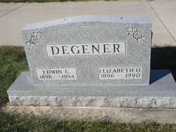

Edwin C Degener
| Birth | : | 27 Jun 1898 |
| Death | : | 27 Dec 1954 |
| Burial | : | St Paul Churchyard, Bisterne, New Forest District, England |
| Coordinate | : | 50.8102700, -1.7900000 |
frequently asked questions (FAQ):
-
Where is Edwin C Degener's memorial?
Edwin C Degener's memorial is located at: St Paul Churchyard, Bisterne, New Forest District, England.
-
When did Edwin C Degener death?
Edwin C Degener death on 27 Dec 1954 in
-
Where are the coordinates of the Edwin C Degener's memorial?
Latitude: 50.8102700
Longitude: -1.7900000
Family Members:
Parent

Spouse
Siblings
Children

Flowers:


Nearby Cemetories:
1. St Paul Churchyard
Bisterne, New Forest District, England
Coordinate: 50.8102700, -1.7900000
2. Sopley Cemetery
Sopley, New Forest District, England
Coordinate: 50.7774250, -1.7847770
3. Ringwood Cemetery
Ringwood, New Forest District, England
Coordinate: 50.8433300, -1.7821000
4. St Peter and St Paul Churchyard
Ringwood, New Forest District, England
Coordinate: 50.8475390, -1.7950970
5. St Michael and All Angels Churchyard
Sopley, New Forest District, England
Coordinate: 50.7697400, -1.7794200
6. All Saints Churchyard
Thorney Hill, New Forest District, England
Coordinate: 50.7966900, -1.7215500
7. St Mary the Virgin Churchyard
Bransgore, New Forest District, England
Coordinate: 50.7766150, -1.7302940
8. Poulner Baptist Chapelyard
Ringwood, New Forest District, England
Coordinate: 50.8582700, -1.7590100
9. West Moors Cemetery
West Moors, East Dorset District, England
Coordinate: 50.8158410, -1.8737500
10. St John the Evangelist Churchyard
Bournemouth Unitary Authority, England
Coordinate: 50.7564980, -1.8191740
11. St Luke's Churchyard
Burton, Christchurch Borough, England
Coordinate: 50.7532240, -1.7650090
12. Throop United Reform Churchyard
Throop, Bournemouth Unitary Authority, England
Coordinate: 50.7630100, -1.8497100
13. St John the Baptist Churchyard
Burley, New Forest District, England
Coordinate: 50.8274700, -1.6971500
14. Throop Jewish Cemetery
Bournemouth, Bournemouth Unitary Authority, England
Coordinate: 50.7600190, -1.8504310
15. St Mary and All Saints Churchyard
Ellingham, New Forest District, England
Coordinate: 50.8742140, -1.7964340
16. Burley Chapel Cemetery
Burley, New Forest District, England
Coordinate: 50.8313000, -1.6930000
17. St. Mary the Virgin Church Cemetery
West Moors, East Dorset District, England
Coordinate: 50.8299273, -1.8895069
18. St Mary Churchyard
Ferndown, East Dorset District, England
Coordinate: 50.7997260, -1.8935890
19. Christchurch Cemetery
Christchurch, Christchurch Borough, England
Coordinate: 50.7427800, -1.7940900
20. All Saints Churchyard
West Parley, East Dorset District, England
Coordinate: 50.7710152, -1.8783700
21. Verwood Cemetery
Verwood, East Dorset District, England
Coordinate: 50.8709100, -1.8510700
22. St. Martin's Churchyard
Ibsley, New Forest District, England
Coordinate: 50.8835000, -1.7893100
23. St Michael and All Angels Churchyard
Hinton, New Forest District, England
Coordinate: 50.7623700, -1.7002000
24. Christchurch Congregational Church Graveyards
Christchurch, Christchurch Borough, England
Coordinate: 50.7347966, -1.7762867