


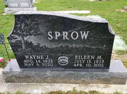
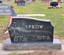
Eileen Marguerite Beerbower Sprow
| Birth | : | 15 Jul 1925 Farmer Township, Defiance County, Ohio, USA |
| Death | : | 10 Apr 2022 Defiance County, Ohio, USA |
| Burial | : | Farmer Cemetery, Farmer, Defiance County, USA |
| Coordinate | : | 41.3903008, -84.6410980 |
| Description | : | Eileen Sprow peacefully passed away in her beloved home on Palm Sunday, April 10, 2022, with her children by her side. Eileen Marguerite (Beerbower) Sprow was born July 15, 1925, at the family home in Farmer Township, to Lester and Esther (Husted) Beerbower. She had one sister, Jean, and a brother, Kenneth, who died on his first birthday. Eileen attended District One schoolhouse in Farmer Township and graduated from Farmer High School, and after graduation, enlisted as a World War II Cadet Nurse. Eileen met handsome Wayne Sprow on a blind date, married him in 1945, and shared 75... Read More |
frequently asked questions (FAQ):
-
Where is Eileen Marguerite Beerbower Sprow's memorial?
Eileen Marguerite Beerbower Sprow's memorial is located at: Farmer Cemetery, Farmer, Defiance County, USA.
-
When did Eileen Marguerite Beerbower Sprow death?
Eileen Marguerite Beerbower Sprow death on 10 Apr 2022 in Defiance County, Ohio, USA
-
Where are the coordinates of the Eileen Marguerite Beerbower Sprow's memorial?
Latitude: 41.3903008
Longitude: -84.6410980
Family Members:
Parent

Spouse
Siblings

Children

Flowers:


Nearby Cemetories:
1. Farmer Cemetery
Farmer, Defiance County, USA
Coordinate: 41.3903008, -84.6410980
2. Upper Lost Creek Cemetery
Farmer, Defiance County, USA
Coordinate: 41.3840000, -84.6700000
3. Kemp Cemetery
Defiance County, USA
Coordinate: 41.3703003, -84.6802979
4. Lost Creek Cemetery
Farmer, Defiance County, USA
Coordinate: 41.3553000, -84.6700000
5. Williams Center Cemetery
Williams Center, Williams County, USA
Coordinate: 41.4288902, -84.6125031
6. Tamarack Cemetery
Milford Township, Defiance County, USA
Coordinate: 41.4117012, -84.7089005
7. Zion Lutheran Church Cemetery
Defiance County, USA
Coordinate: 41.4261017, -84.7099991
8. Fetters Cemetery
Williams County, USA
Coordinate: 41.4519500, -84.6159900
9. Melbern-Neihardt Cemetery
Melbern, Williams County, USA
Coordinate: 41.4633600, -84.6416330
10. Lintz Cemetery
Ney, Defiance County, USA
Coordinate: 41.3760986, -84.5402985
11. Trinity Lutheran Cemetery
Ney, Defiance County, USA
Coordinate: 41.4016991, -84.5353012
12. Yackee Cemetery
Williams County, USA
Coordinate: 41.4707985, -84.6324997
13. Ney Cemetery
Ney, Defiance County, USA
Coordinate: 41.3856010, -84.5271988
14. Six Corners Cemetery
Hicksville, Defiance County, USA
Coordinate: 41.3213997, -84.7153015
15. Saint Johns Lutheran Cemetery
Sherwood, Defiance County, USA
Coordinate: 41.3092003, -84.5931015
16. Doud Cemetery
Ney, Defiance County, USA
Coordinate: 41.3811680, -84.5161110
17. Fountain Grove Cemetery
Bryan, Williams County, USA
Coordinate: 41.4572182, -84.5480576
18. Thomas Cemetery
Williams County, USA
Coordinate: 41.4769100, -84.6994240
19. Brown Cemetery
Bryan, Williams County, USA
Coordinate: 41.4822006, -84.5935974
20. Maple Grove Cemetery
Edgerton, Williams County, USA
Coordinate: 41.4435997, -84.7521973
21. St. Mary's Cemetery
Edgerton, Williams County, USA
Coordinate: 41.4441120, -84.7542700
22. Clarksville Cemetery
Edgerton, Williams County, USA
Coordinate: 41.4281006, -84.7677994
23. Auglaize Village Cemetery
Defiance, Defiance County, USA
Coordinate: 41.3399760, -84.5165610
24. Funk Cemetery
Defiance County, USA
Coordinate: 41.3396988, -84.5164032