
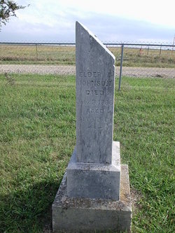
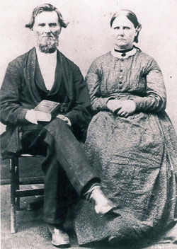
Elder Ezra Johnson
| Birth | : | 7 Jun 1816 Harrison County, Ohio, USA |
| Death | : | 3 Jul 1896 Pomona, Franklin County, Kansas, USA |
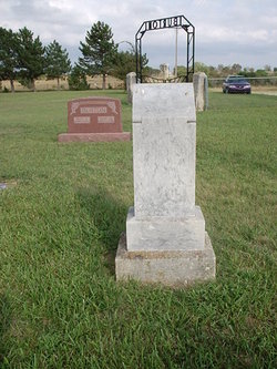
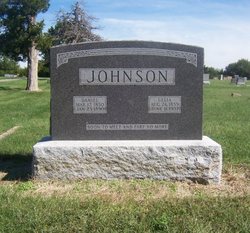
| Burial | : | Saint John Cemetery, Saint Bernard, Hamilton County, USA |
| Coordinate | : | 39.1643982, -84.5053024 |
| Description | : | Aged 80 years, 26 days Elder Ezra Johnson, after an illness of eleven days, departed this life July 3, age 80 years, 26 days. He was born in Harrison County, Ohio June 7, 1816. In 1847, he was one of the five masters who framed the article of faith of the Union Baptist Church. In 1857, he moved to Kansas where has labored ever since in the Gospel of the Son of God. He had the misfortune to lose his eye site two years ago and since then he has not preached regularly, but has been the great counselor... Read More |
frequently asked questions (FAQ):
-
Where is Elder Ezra Johnson's memorial?
Elder Ezra Johnson's memorial is located at: Saint John Cemetery, Saint Bernard, Hamilton County, USA.
-
When did Elder Ezra Johnson death?
Elder Ezra Johnson death on 3 Jul 1896 in Pomona, Franklin County, Kansas, USA
-
Where are the coordinates of the Elder Ezra Johnson's memorial?
Latitude: 39.1643982
Longitude: -84.5053024
Family Members:
Spouse

Children
Flowers:


Nearby Cemetories:
1. Saint John Cemetery
Saint Bernard, Hamilton County, USA
Coordinate: 39.1643982, -84.5053024
2. Vine Street Hill Cemetery
Cincinnati, Hamilton County, USA
Coordinate: 39.1516991, -84.5091019
3. Saint Mary Cemetery
Saint Bernard, Hamilton County, USA
Coordinate: 39.1664009, -84.4880981
4. Spring Grove Cemetery
Cincinnati, Hamilton County, USA
Coordinate: 39.1647900, -84.5231500
5. First German Protestant Cemetery
Avondale, Hamilton County, USA
Coordinate: 39.1492004, -84.4863968
6. Clifton United Jewish Cemetery
Cincinnati, Hamilton County, USA
Coordinate: 39.1470871, -84.5292816
7. Hillside Chapel Crematory and Columbarium
Cincinnati, Hamilton County, USA
Coordinate: 39.1393509, -84.5247192
8. Methodist Protestant Cemetery (Defunct)
Cincinnati, Hamilton County, USA
Coordinate: 39.1324770, -84.4983160
9. Wesleyan Cemetery
Cincinnati, Hamilton County, USA
Coordinate: 39.1599998, -84.5468979
10. Old Finneytown Cemetery
Finneytown, Hamilton County, USA
Coordinate: 39.1962220, -84.5206120
11. Walnut Hills Cemetery
Cincinnati, Hamilton County, USA
Coordinate: 39.1355950, -84.4809040
12. Walnut Hills Jewish Cemetery
Evanston, Hamilton County, USA
Coordinate: 39.1403700, -84.4731300
13. Calvary Cemetery
Cincinnati, Hamilton County, USA
Coordinate: 39.1403008, -84.4697037
14. Longview Hospital Cemetery
Roselawn, Hamilton County, USA
Coordinate: 39.1887730, -84.4691660
15. Third Quaker Cemetery (Defunct)
Cincinnati, Hamilton County, USA
Coordinate: 39.1542400, -84.5523720
16. Convent of the Good Shepherd Cemetery (Defunct)
Carthage, Hamilton County, USA
Coordinate: 39.2055250, -84.5042780
17. Bishop Cemetery (Defunct)
College Hill, Hamilton County, USA
Coordinate: 39.1910210, -84.5489570
18. Griffins Station Cemetery
Carthage, Hamilton County, USA
Coordinate: 39.2047000, -84.4770730
19. Fulton Cemetery
Hyde Park, Hamilton County, USA
Coordinate: 39.1406364, -84.4506302
20. City Infirmary Cemetery
Hartwell, Hamilton County, USA
Coordinate: 39.2123500, -84.4806700
21. Christ Church Cemetery
Over-The-Rhine, Hamilton County, USA
Coordinate: 39.1126480, -84.5157623
22. Second Quaker Cemetery (Defunct)
Cincinnati, Hamilton County, USA
Coordinate: 39.1153090, -84.5305240
23. Baltimore Pike Cemetery
Cincinnati, Hamilton County, USA
Coordinate: 39.1397018, -84.5681000
24. Gard-Brown Cemetery
North Bend, Hamilton County, USA
Coordinate: 39.2035200, -84.5553300