
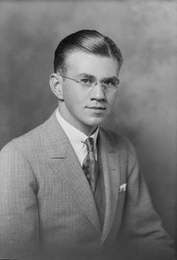
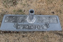
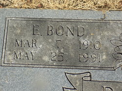
Eldred Bond Proctor Sr.
| Birth | : | 7 Mar 1910 Olean, Miller County, Missouri, USA |
| Death | : | 25 May 1991 Jefferson City, Cole County, Missouri, USA |
| Burial | : | Downsville Cemetery, Pottawattamie County, USA |
| Coordinate | : | 41.3502998, -95.7039032 |
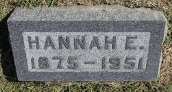
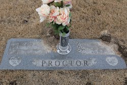
| Description | : | Jefferson City News-Tribune, Sunday, May 26, 1991 E. Bond Proctor Sr., 81, California, died Saturday at Memorial Community Hospital, Jefferson City. He was born March 7, 1910, at Olean, a son of James O. and Hannah Ellen Bond Proctor. On July 20, 1935, he was married at California to Lela Frances Moore, who survives of the home. He was president of Proctor Lumber Co., California, which he was serving in a retired capacity at the time of his death. He was a member of the First Baptist Church, California. He was a 1929 graduate of California... Read More |
frequently asked questions (FAQ):
-
Where is Eldred Bond Proctor Sr.'s memorial?
Eldred Bond Proctor Sr.'s memorial is located at: Downsville Cemetery, Pottawattamie County, USA.
-
When did Eldred Bond Proctor Sr. death?
Eldred Bond Proctor Sr. death on 25 May 1991 in Jefferson City, Cole County, Missouri, USA
-
Where are the coordinates of the Eldred Bond Proctor Sr.'s memorial?
Latitude: 41.3502998
Longitude: -95.7039032
Family Members:
Parent
Spouse

Siblings
Children
Flowers:


Nearby Cemetories:
1. Downsville Cemetery
Pottawattamie County, USA
Coordinate: 41.3502998, -95.7039032
2. Saint Columbanus Cemetery
Weston, Pottawattamie County, USA
Coordinate: 41.3429440, -95.7435260
3. Pottawattamie County Home Cemetery
McClelland, Pottawattamie County, USA
Coordinate: 41.3269400, -95.6691738
4. H G Fisher Cemetery
Underwood, Pottawattamie County, USA
Coordinate: 41.3838997, -95.6889038
5. Castor Cemetery
Underwood, Pottawattamie County, USA
Coordinate: 41.4127040, -95.6887490
6. Hazel Dell Cemetery
Council Bluffs, Pottawattamie County, USA
Coordinate: 41.3489723, -95.7939911
7. Hardin Township Cemetery
McClelland, Pottawattamie County, USA
Coordinate: 41.2949982, -95.6513977
8. Gregg Cemetery
Weston, Pottawattamie County, USA
Coordinate: 41.3330000, -95.7931000
9. Garner Cemetery
Council Bluffs, Pottawattamie County, USA
Coordinate: 41.2956161, -95.8001709
10. Jones - Williams Cemetery
Pottawattamie County, USA
Coordinate: 41.3761000, -95.5846000
11. Saint Pauls Lutheran Cemetery
Neola, Pottawattamie County, USA
Coordinate: 41.4337000, -95.7607000
12. Evans Cemetery
Crescent, Pottawattamie County, USA
Coordinate: 41.3255997, -95.8368988
13. Stoker-Graybill Cemetery
Council Bluffs, Pottawattamie County, USA
Coordinate: 41.2532620, -95.7751770
14. Crescent Cemetery
Crescent, Pottawattamie County, USA
Coordinate: 41.3664894, -95.8566208
15. Green Valley Cemetery
Council Bluffs, Pottawattamie County, USA
Coordinate: 41.2743988, -95.8225021
16. Saint Joseph Cemetery
Council Bluffs, Pottawattamie County, USA
Coordinate: 41.2722015, -95.8208008
17. Cedar Lawn Cemetery
Council Bluffs, Pottawattamie County, USA
Coordinate: 41.2694016, -95.8182983
18. Bikhor Cholim Cemetery
Council Bluffs, Pottawattamie County, USA
Coordinate: 41.2703670, -95.8229350
19. Oak Hill Cemetery
Council Bluffs, Pottawattamie County, USA
Coordinate: 41.2700900, -95.8226400
20. Grange Cemetery
Honey Creek, Pottawattamie County, USA
Coordinate: 41.4446678, -95.8034668
21. Walnut Hill Cemetery
Council Bluffs, Pottawattamie County, USA
Coordinate: 41.2719002, -95.8255997
22. Reels Cemetery
Crescent, Pottawattamie County, USA
Coordinate: 41.4234100, -95.8321700
23. William C McIntosh Cemetery
Crescent, Pottawattamie County, USA
Coordinate: 41.4088745, -95.8477097
24. Ridgewood Cemetery
Council Bluffs, Pottawattamie County, USA
Coordinate: 41.2694016, -95.8272018