
Elisha Wing
| Birth | : | 2 Feb 1668 Sandwich, Barnstable County, Massachusetts, USA |
| Death | : | unknown Rochester, Plymouth County, Massachusetts, USA |
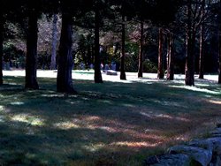
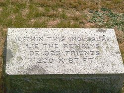
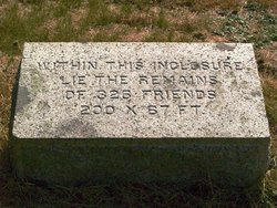
| Burial | : | Friends Burial Ground, Marion, Plymouth County, USA |
| Coordinate | : | 41.7279129, -70.7757416 |
| Description | : | Son of Stephen and Sarah Briggs Wing Husband of Mehitable Butler Elisha, born in Sandwich, Massachusetts, died sometime between the writing of his will (8 Jun 1752) and its probate (19 May 1757). |
frequently asked questions (FAQ):
-
Where is Elisha Wing's memorial?
Elisha Wing's memorial is located at: Friends Burial Ground, Marion, Plymouth County, USA.
-
When did Elisha Wing death?
Elisha Wing death on unknown in Rochester, Plymouth County, Massachusetts, USA
-
Where are the coordinates of the Elisha Wing's memorial?
Latitude: 41.7279129
Longitude: -70.7757416
Family Members:
Parent
Spouse
Siblings

Children
Flowers:


Nearby Cemetories:
1. Friends Burial Ground
Marion, Plymouth County, USA
Coordinate: 41.7279129, -70.7757416
2. North Marion Cemetery
Marion, Plymouth County, USA
Coordinate: 41.7280884, -70.7763062
3. Little Neck Cemetery
Marion, Plymouth County, USA
Coordinate: 41.7175200, -70.7624900
4. Old Landing Cemetery
Marion, Plymouth County, USA
Coordinate: 41.7103004, -70.7707977
5. Perry Family Cemetery
Rochester, Plymouth County, USA
Coordinate: 41.7501840, -70.7914780
6. Saint Gabriels Episcopal Memorial Garden
Marion, Plymouth County, USA
Coordinate: 41.7020200, -70.7626500
7. Evergreen Cemetery
Marion, Plymouth County, USA
Coordinate: 41.6985435, -70.7698517
8. Center Cemetery
Rochester, Plymouth County, USA
Coordinate: 41.7301530, -70.8185830
9. Blankenship Cemetery
Marion, Plymouth County, USA
Coordinate: 41.7076200, -70.7392100
10. Point Road Memorial Forest
Marion, Plymouth County, USA
Coordinate: 41.7071400, -70.7385050
11. Union Cemetery
Rochester, Plymouth County, USA
Coordinate: 41.7573640, -70.8202030
12. Hillside Cemetery
Rochester, Plymouth County, USA
Coordinate: 41.7750015, -70.7889023
13. Tobey-Fearing-Bliss Cemetery (Defunct)
Wareham, Plymouth County, USA
Coordinate: 41.7722600, -70.7464100
14. Ellis Family Burial Ground
Rochester, Plymouth County, USA
Coordinate: 41.7105620, -70.8397580
15. Centre Cemetery
Wareham, Plymouth County, USA
Coordinate: 41.7708015, -70.7277985
16. Saint Patricks Cemetery
Wareham, Plymouth County, USA
Coordinate: 41.7703018, -70.7264023
17. Woodside Cemetery
Rochester, Plymouth County, USA
Coordinate: 41.7848816, -70.7774887
18. Friends Cemetery
Mattapoisett, Plymouth County, USA
Coordinate: 41.6658110, -70.7838390
19. Saint Anthonys Cemetery
Mattapoisett, Plymouth County, USA
Coordinate: 41.6781060, -70.8271560
20. Howse Family Burial Ground
Rochester, Plymouth County, USA
Coordinate: 41.7262300, -70.8632760
21. Agawam Cemetery
Wareham, Plymouth County, USA
Coordinate: 41.7463989, -70.6908035
22. Pine Island Cemetery
Mattapoisett, Plymouth County, USA
Coordinate: 41.6624947, -70.7928925
23. Ellis Cemetery
Mattapoisett, Plymouth County, USA
Coordinate: 41.6957817, -70.8545609
24. Sherman Cemetery
Rochester, Plymouth County, USA
Coordinate: 41.7467728, -70.8678284