
| Birth | : | 8 Sep 1848 Forreston, Ogle County, Illinois, USA |
| Death | : | 4 Feb 1937 Marshall County, Iowa, USA |
| Burial | : | Fleetwood Cemetery, Fleetwood, Wyre Borough, England |
| Coordinate | : | 53.9223440, -3.0370570 |
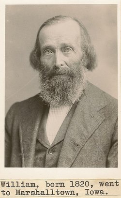
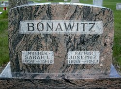
| Description | : | OBITUARY: Mrs. Elizabeth Wickersham passed away at her home, 806 West Church street at 12:40 this morning after an illness of four and one-half months. She had been in failing health for the past two years. Death was due to infirmities of age. Mrs. Wickersham was born Sept. 8, 1848 at Forreston, Ill., a daughter of William and Phoebe Bonawitz. She came to Iowa with her parents at the age of 15 settling near Vancleve. She was married to Thomas G. Wickersham March 19, 1873, near Luray. After their marriage Mr. and Mrs. Wickersham lived on a farm near... Read More |
frequently asked questions (FAQ):
-
Where is Elizabeth Bonawitz Wickersham's memorial?
Elizabeth Bonawitz Wickersham's memorial is located at: Fleetwood Cemetery, Fleetwood, Wyre Borough, England.
-
When did Elizabeth Bonawitz Wickersham death?
Elizabeth Bonawitz Wickersham death on 4 Feb 1937 in Marshall County, Iowa, USA
-
Where are the coordinates of the Elizabeth Bonawitz Wickersham's memorial?
Latitude: 53.9223440
Longitude: -3.0370570
Family Members:
Parent

Spouse
Siblings
Children
Flowers:


Nearby Cemetories:
1. Fleetwood Cemetery
Fleetwood, Wyre Borough, England
Coordinate: 53.9223440, -3.0370570
2. St. Peter and St. David Churchyard
Fleetwood, Wyre Borough, England
Coordinate: 53.9238123, -3.0116212
3. Preesall Cemetery
Preesall, Wyre Borough, England
Coordinate: 53.9075410, -2.9635410
4. Christ Church Thornton Churchyard
Thornton-Cleveleys, Wyre Borough, England
Coordinate: 53.8772800, -3.0221100
5. St James Churchyard
Stalmine, Wyre Borough, England
Coordinate: 53.9020510, -2.9533720
6. All Hallow's Churchyard
Bispham, Blackpool Unitary Authority, England
Coordinate: 53.8567580, -3.0372160
7. St John the Baptist's Church
Pilling, Wyre Borough, England
Coordinate: 53.9289910, -2.9114540
8. St Johns Roman Catholic Church Cemetery
Poulton-le-Fylde, Wyre Borough, England
Coordinate: 53.8520854, -2.9873511
9. Blackpool Cemetery and Crematorium
Poulton-le-Fylde, Wyre Borough, England
Coordinate: 53.8465680, -3.0196600
10. Saint Chad Churchyard
Poulton-le-Fylde, Wyre Borough, England
Coordinate: 53.8471992, -2.9925005
11. St Stephen On-the-Cliffs Churchyard
Blackpool, Blackpool Unitary Authority, England
Coordinate: 53.8407230, -3.0515610
12. St William of York Church
Pilling, Wyre Borough, England
Coordinate: 53.9235047, -2.8934617
13. Poulton-Le-Fylde Old Cemetery
Poulton-le-Fylde, Wyre Borough, England
Coordinate: 53.8458145, -2.9713324
14. Poulton New Cemetery
Poulton-le-Fylde, Wyre Borough, England
Coordinate: 53.8461240, -2.9689560
15. Blackpool Jewish Cemetery
Blackpool, Blackpool Unitary Authority, England
Coordinate: 53.8287397, -3.0311753
16. St Paul's Church & Medical Centre
Blackpool Unitary Authority, England
Coordinate: 53.8291540, -3.0533490
17. Layton Cemetery
Blackpool, Blackpool Unitary Authority, England
Coordinate: 53.8273740, -3.0328240
18. St. John’s Churchyard
Out Rawcliffe, Wyre Borough, England
Coordinate: 53.8741650, -2.8959310
19. St. Anne's Churchyard
Blackburn, Blackburn with Darwen Unitary Authority, England
Coordinate: 53.8381160, -2.9362870
20. St Anne Churchyard
Singleton, Fylde Borough, England
Coordinate: 53.8379280, -2.9359890
21. St John the Evangelist Churchyard
Blackpool, Blackpool Unitary Authority, England
Coordinate: 53.8182303, -3.0508197
22. Carlton Cemetery& Crematorium
Blackpool, Blackpool Unitary Authority, England
Coordinate: 53.8095921, -3.0364920
23. St Anne Churchyard
Great Eccleston, Wyre Borough, England
Coordinate: 53.8481413, -2.8835925
24. Saint Paul Churchyard
Great Marton, Blackpool Unitary Authority, England
Coordinate: 53.8053220, -3.0268330