
| Birth | : | 1878 |
| Death | : | 12 Nov 1949 Golden, Jefferson County, Colorado, USA |
| Burial | : | Walnut Hill Cemetery, Council Bluffs, Pottawattamie County, USA |
| Coordinate | : | 41.2719002, -95.8255997 |
| Plot | : | Section 8, Lot 336, Space 5 |
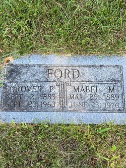
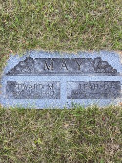
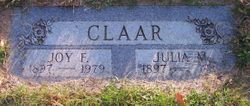
| Description | : | ---------- Listed as age 71, died at the home of her daughter, Dr. Hazel Archer of Golden, Colo. Survived by husband, L. O. Claar; five sons, Joy F. and Glen E. of Council Bluffs, Earl W. of Long Beach, Calif., Glee and Roy of Golden, Colo.; five daughters, Mrs. Grace Holt of Council Bluffs, Mrs. Mildred Cameron, Mrs. Hazel Archer, and Mrs. Helen Miller, all of Golden, Colo., and Mrs. Norma Basey of Greeley, Colo.; three sisters, Mrs. Leah May of Oak Park, Ill., Mrs. Nellie Geiser of Golden, and Mrs. Pearl McCampbell of Springfield, Ohio; seven brothers, W. A. Ford... Read More |
frequently asked questions (FAQ):
-
Where is Elizabeth E. “Lizzie” Ford Claar's memorial?
Elizabeth E. “Lizzie” Ford Claar's memorial is located at: Walnut Hill Cemetery, Council Bluffs, Pottawattamie County, USA.
-
When did Elizabeth E. “Lizzie” Ford Claar death?
Elizabeth E. “Lizzie” Ford Claar death on 12 Nov 1949 in Golden, Jefferson County, Colorado, USA
-
Where are the coordinates of the Elizabeth E. “Lizzie” Ford Claar's memorial?
Latitude: 41.2719002
Longitude: -95.8255997
Family Members:
Parent

Spouse
Siblings
Children
Flowers:


Nearby Cemetories:
1. Walnut Hill Cemetery
Council Bluffs, Pottawattamie County, USA
Coordinate: 41.2719002, -95.8255997
2. Bikhor Cholim Cemetery
Council Bluffs, Pottawattamie County, USA
Coordinate: 41.2703670, -95.8229350
3. Ridgewood Cemetery
Council Bluffs, Pottawattamie County, USA
Coordinate: 41.2694016, -95.8272018
4. Oak Hill Cemetery
Council Bluffs, Pottawattamie County, USA
Coordinate: 41.2700900, -95.8226400
5. Green Valley Cemetery
Council Bluffs, Pottawattamie County, USA
Coordinate: 41.2743988, -95.8225021
6. Saint Joseph Cemetery
Council Bluffs, Pottawattamie County, USA
Coordinate: 41.2722015, -95.8208008
7. Cedar Lawn Cemetery
Council Bluffs, Pottawattamie County, USA
Coordinate: 41.2694016, -95.8182983
8. Memorial Park Cemetery
Council Bluffs, Pottawattamie County, USA
Coordinate: 41.2644005, -95.8261032
9. Clark Cemetery
Pottawattamie County, USA
Coordinate: 41.2551610, -95.8223390
10. Fairview Cemetery
Council Bluffs, Pottawattamie County, USA
Coordinate: 41.2703018, -95.8480988
11. Garner Cemetery
Council Bluffs, Pottawattamie County, USA
Coordinate: 41.2956161, -95.8001709
12. Stoker-Graybill Cemetery
Council Bluffs, Pottawattamie County, USA
Coordinate: 41.2532620, -95.7751770
13. Maple Grove Cemetery
Council Bluffs, Pottawattamie County, USA
Coordinate: 41.2265560, -95.8187100
14. Evans Cemetery
Crescent, Pottawattamie County, USA
Coordinate: 41.3255997, -95.8368988
15. Lewis Township Cemetery
Council Bluffs, Pottawattamie County, USA
Coordinate: 41.2117004, -95.7938995
16. Gregg Cemetery
Weston, Pottawattamie County, USA
Coordinate: 41.3330000, -95.7931000
17. Council Point Cemetery
Council Bluffs, Pottawattamie County, USA
Coordinate: 41.2110830, -95.8788610
18. Hazel Dell Cemetery
Council Bluffs, Pottawattamie County, USA
Coordinate: 41.3489723, -95.7939911
19. Trinity Cathedral Columbarium
Omaha, Douglas County, USA
Coordinate: 41.2603900, -95.9393660
20. Saint Columbanus Cemetery
Weston, Pottawattamie County, USA
Coordinate: 41.3429440, -95.7435260
21. Crescent Cemetery
Crescent, Pottawattamie County, USA
Coordinate: 41.3664894, -95.8566208
22. Prospect Hill Cemetery
Omaha, Douglas County, USA
Coordinate: 41.2780991, -95.9593964
23. First Central Congregational Columbarium
Omaha, Douglas County, USA
Coordinate: 41.2563456, -95.9658365
24. Nash Chapel Crypt
Omaha, Douglas County, USA
Coordinate: 41.2665090, -95.9721790