
| Birth | : | 23 Feb 1957 Overton County, Tennessee, USA |
| Death | : | 6 Apr 2015 Cookeville, Putnam County, Tennessee, USA |
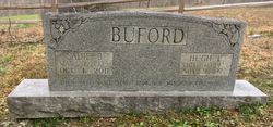
| Burial | : | Dale Davis Cemetery, Clay County, USA |
| Coordinate | : | 36.5143600, -85.4685300 |
| Description | : | Funeral services for Ms. Elizabeth "Libby" Buford Harris, age 58, of Cookeville formerly of Overton County will be conducted at 1 p.m., Thursday April 9, 2015 from the chapel of Speck Funeral Home in Livingston with Rev. Dee Wells and Rev. David Moore officiating. Burial will be in the Davis Family Cemetery in Clay County. The family will receive friends on Wednesday evening from 6 until 9 p.m. Ms. Harris passed away April 6, 2015 at Cookeville Regional Medical Center. She was born February 23, 1957 in Overton County to the late Hugh & Sadie Johnson Buford. She was a... Read More |
frequently asked questions (FAQ):
-
Where is Elizabeth “Libby” Buford Harris's memorial?
Elizabeth “Libby” Buford Harris's memorial is located at: Dale Davis Cemetery, Clay County, USA.
-
When did Elizabeth “Libby” Buford Harris death?
Elizabeth “Libby” Buford Harris death on 6 Apr 2015 in Cookeville, Putnam County, Tennessee, USA
-
Where are the coordinates of the Elizabeth “Libby” Buford Harris's memorial?
Latitude: 36.5143600
Longitude: -85.4685300
Family Members:
Parent

Flowers:


Nearby Cemetories:
1. Dale Davis Cemetery
Clay County, USA
Coordinate: 36.5143600, -85.4685300
2. Walker Cemetery
Celina, Clay County, USA
Coordinate: 36.5372009, -85.4728012
3. Keen Cemetery
Clay County, USA
Coordinate: 36.5116997, -85.4385986
4. Peterman Bend Cemetery
Celina, Clay County, USA
Coordinate: 36.5370750, -85.4846300
5. Robert Arms Cemetery
Pea Ridge, Clay County, USA
Coordinate: 36.5432790, -85.4657820
6. Gates Cemetery
Celina, Clay County, USA
Coordinate: 36.5422640, -85.4891440
7. Tinsley Cemetery
Cave Springs, Clay County, USA
Coordinate: 36.5527992, -85.4800034
8. Smith Family Cemetery
Clay County, USA
Coordinate: 36.5073684, -85.4173430
9. Old Fitzgerald Cemetery
Celina, Clay County, USA
Coordinate: 36.5509750, -85.4958417
10. Fitzgerald Cemetery
Celina, Clay County, USA
Coordinate: 36.5518990, -85.4966965
11. Hamilton Cemetery
Celina, Clay County, USA
Coordinate: 36.5517271, -85.4970509
12. Green Cemetery
Celina, Clay County, USA
Coordinate: 36.5496418, -85.5024450
13. McDonald Cemetery
Baptist Ridge, Clay County, USA
Coordinate: 36.4855995, -85.5119019
14. Rich Cemetery
Baptist Ridge, Clay County, USA
Coordinate: 36.4757080, -85.4991700
15. Page Family Cemetery
Free Hill, Clay County, USA
Coordinate: 36.5623018, -85.4844294
16. Buford Cemetery
Clay County, USA
Coordinate: 36.5405998, -85.4139023
17. Emberton Cemetery
Celina, Clay County, USA
Coordinate: 36.4862150, -85.5237040
18. Hamilton Cemetery
Clay County, USA
Coordinate: 36.5181007, -85.5338974
19. Free Hill Cemetery
Clay County, USA
Coordinate: 36.5628014, -85.4955978
20. McFerrin Cemetery
Overton County, USA
Coordinate: 36.4902992, -85.4075012
21. M R Cemetery
Baptist Ridge, Clay County, USA
Coordinate: 36.4769100, -85.5196770
22. Burchett Cemetery
Overton County, USA
Coordinate: 36.4925003, -85.4041977
23. Hall Cemetery
Clay County, USA
Coordinate: 36.4994011, -85.5366974
24. Doc Hall Cemetery
Clay County, USA
Coordinate: 36.4995390, -85.5369270