

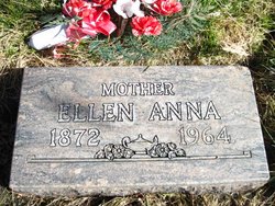
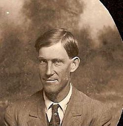
Ellen Anna Smith Rommel
| Birth | : | 27 Aug 1872 Adin, Modoc County, California, USA |
| Death | : | 12 Aug 1964 Pomeroy, Garfield County, Washington, USA |
| Burial | : | Agawam Cemetery, Wareham, Plymouth County, USA |
| Coordinate | : | 41.7463989, -70.6908035 |
| Description | : | Daughter of Matthew Clay Smith and Mary Mark Simpson. She married Christian Henry Rommel on December 2, 1893 in Pomeroy, Garfield, Washington. Three known children were born to this union: Fred Clay Rommel Mary Pauline Rommel Miller Eva Christine Rommel Knowlton |
frequently asked questions (FAQ):
-
Where is Ellen Anna Smith Rommel's memorial?
Ellen Anna Smith Rommel's memorial is located at: Agawam Cemetery, Wareham, Plymouth County, USA.
-
When did Ellen Anna Smith Rommel death?
Ellen Anna Smith Rommel death on 12 Aug 1964 in Pomeroy, Garfield County, Washington, USA
-
Where are the coordinates of the Ellen Anna Smith Rommel's memorial?
Latitude: 41.7463989
Longitude: -70.6908035
Family Members:
Parent

Spouse
Siblings
Flowers:


Nearby Cemetories:
1. Agawam Cemetery
Wareham, Plymouth County, USA
Coordinate: 41.7463989, -70.6908035
2. Saint Patricks Cemetery
Wareham, Plymouth County, USA
Coordinate: 41.7703018, -70.7264023
3. Centre Cemetery
Wareham, Plymouth County, USA
Coordinate: 41.7708015, -70.7277985
4. Long Neck Cemetery
Wareham, Plymouth County, USA
Coordinate: 41.7461014, -70.6369019
5. Nickerson Burial Ground
Plymouth, Plymouth County, USA
Coordinate: 41.7642740, -70.6306530
6. Tobey-Fearing-Bliss Cemetery (Defunct)
Wareham, Plymouth County, USA
Coordinate: 41.7722600, -70.7464100
7. Point Road Memorial Forest
Marion, Plymouth County, USA
Coordinate: 41.7071400, -70.7385050
8. Blankenship Cemetery
Marion, Plymouth County, USA
Coordinate: 41.7076200, -70.7392100
9. Monument Neck Cemetery
Gray Gables, Barnstable County, USA
Coordinate: 41.7346001, -70.6128006
10. Little Neck Cemetery
Marion, Plymouth County, USA
Coordinate: 41.7175200, -70.7624900
11. Oakland Grove Cemetery
Bourne, Barnstable County, USA
Coordinate: 41.7402992, -70.6042023
12. Bourne Family Cemetery
Bourne, Barnstable County, USA
Coordinate: 41.7501602, -70.6032104
13. Friends Burial Ground
Marion, Plymouth County, USA
Coordinate: 41.7279129, -70.7757416
14. North Marion Cemetery
Marion, Plymouth County, USA
Coordinate: 41.7280884, -70.7763062
15. Monument Beach Cemetery
Monument Beach, Barnstable County, USA
Coordinate: 41.7151800, -70.6094600
16. Bourne Family Cemetery #02
Bourne, Barnstable County, USA
Coordinate: 41.7577230, -70.6001190
17. Old Bourne Cemetery
Bourne, Barnstable County, USA
Coordinate: 41.7386017, -70.5986023
18. Saint Gabriels Episcopal Memorial Garden
Marion, Plymouth County, USA
Coordinate: 41.7020200, -70.7626500
19. Old Landing Cemetery
Marion, Plymouth County, USA
Coordinate: 41.7103004, -70.7707977
20. Bourne Village Cemetery
Bourne, Barnstable County, USA
Coordinate: 41.7425117, -70.5938110
21. Perry Family Cemetery
Rochester, Plymouth County, USA
Coordinate: 41.7501840, -70.7914780
22. Woodside Cemetery
Rochester, Plymouth County, USA
Coordinate: 41.7848816, -70.7774887
23. Evergreen Cemetery
Marion, Plymouth County, USA
Coordinate: 41.6985435, -70.7698517
24. Hillside Cemetery
Rochester, Plymouth County, USA
Coordinate: 41.7750015, -70.7889023