
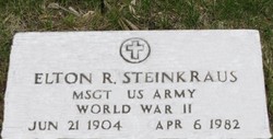

Elton Robert Steinkraus
| Birth | : | 21 Jun 1904 Pierce, Pierce County, Nebraska, USA |
| Death | : | 6 Apr 1982 Temecula, Riverside County, California, USA |
| Burial | : | Bethpage Baptist Church Cemetery, Gibson County, USA |
| Coordinate | : | 36.1683000, -89.0950000 |
| Plot | : | Blk _, Lot _, Grv 1678 |
| Description | : | Elton was a World War II Veteran |
frequently asked questions (FAQ):
-
Where is Elton Robert Steinkraus's memorial?
Elton Robert Steinkraus's memorial is located at: Bethpage Baptist Church Cemetery, Gibson County, USA.
-
When did Elton Robert Steinkraus death?
Elton Robert Steinkraus death on 6 Apr 1982 in Temecula, Riverside County, California, USA
-
Where are the coordinates of the Elton Robert Steinkraus's memorial?
Latitude: 36.1683000
Longitude: -89.0950000
Family Members:
Parent
Spouse

Siblings
Children

Flowers:


Nearby Cemetories:
1. Bethpage Baptist Church Cemetery
Gibson County, USA
Coordinate: 36.1683000, -89.0950000
2. North Union Cemetery
Kenton, Gibson County, USA
Coordinate: 36.1652985, -89.0736008
3. Mason Hall Cemetery
Mason Hall, Obion County, USA
Coordinate: 36.2042100, -89.0935750
4. Cool Springs Cumberland Presbyterian Cemetery
Cool Springs, Gibson County, USA
Coordinate: 36.1618996, -89.1393967
5. Pettus Family Cemetery
Yorkville, Gibson County, USA
Coordinate: 36.1797000, -89.1472700
6. New Salem Baptist Church Cemetery
Mason Hall, Obion County, USA
Coordinate: 36.2150800, -89.1016300
7. Hollomon Cemetery
Mason Hall, Obion County, USA
Coordinate: 36.2143980, -89.0792070
8. Liberty Grove Cemetery
Rutherford, Gibson County, USA
Coordinate: 36.1439760, -89.0371100
9. Jones Cemetery
Trimble, Dyer County, USA
Coordinate: 36.1891590, -89.1589510
10. Bells Chapel Cemetery
Dyer, Gibson County, USA
Coordinate: 36.1164017, -89.0686035
11. Reed Burial Ground
Yorkville, Gibson County, USA
Coordinate: 36.1176420, -89.1372490
12. West Side Cemetery
Kenton, Gibson County, USA
Coordinate: 36.1979200, -89.0267000
13. Sunnyside Cemetery
Kenton, Gibson County, USA
Coordinate: 36.1982994, -89.0252991
14. Smithson-Askew Cemetery
Rutherford, Gibson County, USA
Coordinate: 36.1667300, -89.0159600
15. Carroll Cemetery
Rutherford, Gibson County, USA
Coordinate: 36.1453900, -89.0140800
16. Rossons Cemetery
Kenton, Gibson County, USA
Coordinate: 36.1799158, -89.0083141
17. Thompson Cemetery
Rutherford, Gibson County, USA
Coordinate: 36.1047220, -89.0553430
18. Yorkville Cumberland Presbyterian Church Cemetery
Yorkville, Gibson County, USA
Coordinate: 36.1007996, -89.1231003
19. Cowan Cemetery
Dyer, Gibson County, USA
Coordinate: 36.0978120, -89.0753020
20. Roach Cemetery
Obion County, USA
Coordinate: 36.2398222, -89.1122983
21. New Concord Cemetery
Kenton, Obion County, USA
Coordinate: 36.2222210, -89.0341160
22. Yorkville Cemetery
Yorkville, Gibson County, USA
Coordinate: 36.0980988, -89.1207962
23. Flowers Chapel Cemetery
Rutherford, Gibson County, USA
Coordinate: 36.1198820, -89.0265080
24. Miles Cemetery
Kenton, Obion County, USA
Coordinate: 36.2453720, -89.1021810