
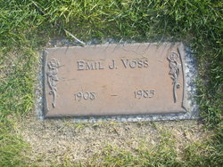
Emil John Voss
| Birth | : | 22 Mar 1908 Olpe, Lyon County, Kansas, USA |
| Death | : | 29 Oct 1985 North Platte, Lincoln County, Nebraska, USA |
| Burial | : | St. Helen's Churchyard, Escrick, Selby District, England |
| Coordinate | : | 53.8805200, -1.0460990 |
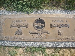
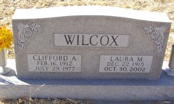
| Description | : | Emil John Voss March 22,1908-Oct 29,1985 Emil J. Voss,77, of 2201 W 13th, died in a North Platte nursing home. He was born March 22, 1908, in Olpe, Kan., to Joseph John and Mary Anthe Voss. He moved to rural Hershey with his parents where he grew up. He farmed northeast of Hershey until his retirement in 1980. Survivors include three brothers, Joseph T. of North Platte, Earnest of Brady and Henry "Doc" of Portland, Ore.; two sisters, Hilda Voss of Denver, Colo.; and Mrs. Laura Wilcox of Lexington. Services will be at the Tabler Memorial Chapel. Burial... Read More |
frequently asked questions (FAQ):
-
Where is Emil John Voss's memorial?
Emil John Voss's memorial is located at: St. Helen's Churchyard, Escrick, Selby District, England.
-
When did Emil John Voss death?
Emil John Voss death on 29 Oct 1985 in North Platte, Lincoln County, Nebraska, USA
-
Where are the coordinates of the Emil John Voss's memorial?
Latitude: 53.8805200
Longitude: -1.0460990
Family Members:
Parent
Siblings


Flowers:


Nearby Cemetories:
1. St. Helen's Churchyard
Escrick, Selby District, England
Coordinate: 53.8805200, -1.0460990
2. St Matthew Churchyard
Naburn, York Unitary Authority, England
Coordinate: 53.9009520, -1.0899200
3. St Helen Churchyard
Stillingfleet, Selby District, England
Coordinate: 53.8618710, -1.0994760
4. Holy Trinity Churchyard
Acaster Malbis, York Unitary Authority, England
Coordinate: 53.9052480, -1.0975170
5. St. Mary's Churchyard
Riccall, Selby District, England
Coordinate: 53.8330620, -1.0601630
6. St. Helen's Churchyard
Skipwith, Selby District, England
Coordinate: 53.8386300, -1.0022900
7. St. Andrew's Old Churchyard
Bishopthorpe, York Unitary Authority, England
Coordinate: 53.9221490, -1.0929640
8. Fulford Cemetery
Fulford, York Unitary Authority, England
Coordinate: 53.9304450, -1.0683670
9. St Helen Churchyard
Wheldrake, York Unitary Authority, England
Coordinate: 53.8965340, -0.9626520
10. St Andrew Churchyard
Bishopthorpe, York Unitary Authority, England
Coordinate: 53.9236690, -1.0955320
11. St John Churchyard
Acaster Selby, Selby District, England
Coordinate: 53.8614750, -1.1283740
12. York Crematorium
York, York Unitary Authority, England
Coordinate: 53.9264970, -1.0936130
13. St Helen Churchyard
Thorganby, Selby District, England
Coordinate: 53.8666100, -0.9530300
14. St Oswald's Old Churchyard
Fulford, York Unitary Authority, England
Coordinate: 53.9391350, -1.0809020
15. Dringhouses Cemetery
York, York Unitary Authority, England
Coordinate: 53.9297740, -1.1156780
16. Moor Lane Burial Ground
Copmanthorpe, York Unitary Authority, England
Coordinate: 53.9096890, -1.1449400
17. St Giles Churchyard
Copmanthorpe, York Unitary Authority, England
Coordinate: 53.9149240, -1.1410420
18. All Saints Churchyard
Cawood, Selby District, England
Coordinate: 53.8331970, -1.1235660
19. All Saints Churchyard
Appleton Roebuck, Selby District, England
Coordinate: 53.8734600, -1.1580870
20. St Paul Churchyard
Heslington, York Unitary Authority, England
Coordinate: 53.9471780, -1.0445150
21. Quaker Cemetery
East Cottingwith, East Riding of Yorkshire Unitary Authority, England
Coordinate: 53.8746050, -0.9327040
22. St Mary Churchyard
East Cottingwith, East Riding of Yorkshire Unitary Authority, England
Coordinate: 53.8738030, -0.9317490
23. Friends Burial Ground
York, York Unitary Authority, England
Coordinate: 53.9478920, -1.0618450
24. Rythergate Cemetery
Cawood, Selby District, England
Coordinate: 53.8356000, -1.1347700