
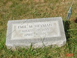
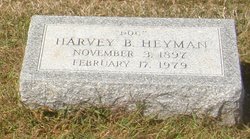
Emil Meyer Heyman
| Birth | : | 27 Aug 1895 Butler County, Kansas, USA |
| Death | : | 4 Apr 1976 Detroit, Wayne County, Michigan, USA |
| Burial | : | Haycombe Cemetery and Crematorium, Bath, Bath and North East Somerset Unitary Authority, England |
| Coordinate | : | 51.3703430, -2.4014760 |
| Description | : | Emil was born about 1.5 miles northeast of DeGraff, Kansas, the second of eight children. At age eight, his parents decided to return to Ohio due to the poor health of his mother. The family settled north of Hunt's Corners, and Emil attended the rural township school and spent his early adult years on the farm. During World War I, he registered for military service on June 5, 1917, and was called to active duty on August 8th. He trained at Camp Sheridan, Montgomery, Alabama, and was assigned to Company C. 26th Machine Gun Battalion. Emil was honorably discharged on February... Read More |
frequently asked questions (FAQ):
-
Where is Emil Meyer Heyman's memorial?
Emil Meyer Heyman's memorial is located at: Haycombe Cemetery and Crematorium, Bath, Bath and North East Somerset Unitary Authority, England.
-
When did Emil Meyer Heyman death?
Emil Meyer Heyman death on 4 Apr 1976 in Detroit, Wayne County, Michigan, USA
-
Where are the coordinates of the Emil Meyer Heyman's memorial?
Latitude: 51.3703430
Longitude: -2.4014760
Family Members:
Parent

Spouse
Siblings
Flowers:


Nearby Cemetories:
1. Haycombe Cemetery and Crematorium
Bath, Bath and North East Somerset Unitary Authority, England
Coordinate: 51.3703430, -2.4014760
2. St Peter Churchyard
Englishcombe, Bath and North East Somerset Unitary Authority, England
Coordinate: 51.3640600, -2.4088700
3. St Michael and All Angels Churchyard
Twerton, Bath and North East Somerset Unitary Authority, England
Coordinate: 51.3809000, -2.3981000
4. Twerton Cemetery
Twerton, Bath and North East Somerset Unitary Authority, England
Coordinate: 51.3802500, -2.3836220
5. Locksbrook Cemetery
Lower Weston, Bath and North East Somerset Unitary Authority, England
Coordinate: 51.3845180, -2.3850300
6. Locksbrook St Saviour's Cemetery
Bath and North East Somerset Unitary Authority, England
Coordinate: 51.3867880, -2.3863380
7. St. Michael's Cemetery
Bath, Bath and North East Somerset Unitary Authority, England
Coordinate: 51.3859700, -2.3814500
8. Bath Union Workhouse Burial Ground
Bath, Bath and North East Somerset Unitary Authority, England
Coordinate: 51.3570889, -2.3773370
9. St. James' Cemetery
Bath, Bath and North East Somerset Unitary Authority, England
Coordinate: 51.3802000, -2.3722200
10. Holy Trinity Churchyard
Newton St Loe, Bath and North East Somerset Unitary Authority, England
Coordinate: 51.3820470, -2.4311300
11. Bath Union Workhouse Graveyard
Bath, Bath and North East Somerset Unitary Authority, England
Coordinate: 51.3584160, -2.3711140
12. Moravian Burial Ground
Bath, Bath and North East Somerset Unitary Authority, England
Coordinate: 51.3894150, -2.3798150
13. St Mary Magdalen Chapel
Widcombe, Bath and North East Somerset Unitary Authority, England
Coordinate: 51.3760486, -2.3643405
14. St Mary's Chapel, Queens Square
Bath, Bath and North East Somerset Unitary Authority, England
Coordinate: 51.3827790, -2.3649790
15. All Saints Churchyard
Weston, Bath and North East Somerset Unitary Authority, England
Coordinate: 51.3956850, -2.3881320
16. St James Old Burial Ground
Bath, Bath and North East Somerset Unitary Authority, England
Coordinate: 51.3798600, -2.3610100
17. Countess of Huntingdon's Chapel
Walcot, Bath and North East Somerset Unitary Authority, England
Coordinate: 51.3967020, -2.3907434
18. Saint Mark's Churchyard
Widcombe, Bath and North East Somerset Unitary Authority, England
Coordinate: 51.3766660, -2.3588010
19. Bath General Hospital Burial Ground
Bath and North East Somerset Unitary Authority, England
Coordinate: 51.3824715, -2.3614742
20. St. Mary de Stall Churchyard (Defunct)
Bath, Bath and North East Somerset Unitary Authority, England
Coordinate: 51.3813350, -2.3600353
21. Quaker Meeting House
Bath, Bath and North East Somerset Unitary Authority, England
Coordinate: 51.3823280, -2.3604380
22. All Saints Churchyard
Corston, Bath and North East Somerset Unitary Authority, England
Coordinate: 51.3857350, -2.4400372
23. Old Orchard Street Catholic Burial Vault
Bath, Bath and North East Somerset Unitary Authority, England
Coordinate: 51.3800370, -2.3579910
24. Bath Abbey
Bath, Bath and North East Somerset Unitary Authority, England
Coordinate: 51.3815310, -2.3586640