
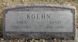
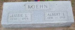
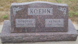
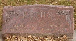
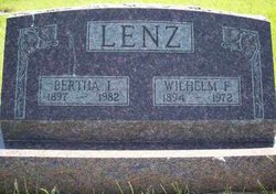
Emilie Struck Koehn
| Birth | : | 8 Oct 1861 Germany |
| Death | : | 2 Dec 1940 Pierce, Pierce County, Nebraska, USA |
| Burial | : | Saint Barnabas Churchyard, Queen Camel, South Somerset District, England |
| Coordinate | : | 51.0225850, -2.5759270 |
| Plot | : | Blk 30, Lot 12, Grv 353 |
frequently asked questions (FAQ):
-
Where is Emilie Struck Koehn's memorial?
Emilie Struck Koehn's memorial is located at: Saint Barnabas Churchyard, Queen Camel, South Somerset District, England.
-
When did Emilie Struck Koehn death?
Emilie Struck Koehn death on 2 Dec 1940 in Pierce, Pierce County, Nebraska, USA
-
Where are the coordinates of the Emilie Struck Koehn's memorial?
Latitude: 51.0225850
Longitude: -2.5759270
Family Members:
Parent

Spouse

Siblings

Children
Flowers:


Nearby Cemetories:
1. St. Mary's Churchyard
Marston Magna, South Somerset District, England
Coordinate: 50.9989970, -2.5805915
2. St. Mary the Virgin Churchyard
Rimpton, South Somerset District, England
Coordinate: 50.9947330, -2.5564860
3. St. James Parish Churchyard
Chilton Cantelo, South Somerset District, England
Coordinate: 50.9972730, -2.6136800
4. St Michael Churchyard
North Cadbury, South Somerset District, England
Coordinate: 51.0416670, -2.5213610
5. Saint Andrew Churchyard
Corton Denham, South Somerset District, England
Coordinate: 51.0015790, -2.5203100
6. Corton Denham Cemetery
Corton Denham, South Somerset District, England
Coordinate: 51.0015810, -2.5202380
7. St Nicolas' Churchyard
North Barrow, South Somerset District, England
Coordinate: 51.0623705, -2.5605033
8. St. Nicholas Churchyard
Sandford Orcas, West Dorset District, England
Coordinate: 50.9874190, -2.5394460
9. Blessed Virgin Mary Churchyard
Compton Pauncefoot, South Somerset District, England
Coordinate: 51.0336770, -2.5089430
10. St Vincent Churchyard
Ashington, South Somerset District, England
Coordinate: 50.9904090, -2.6267630
11. St. Peter’s Churchyard
Podimore, South Somerset District, England
Coordinate: 51.0219250, -2.6492310
12. Holy Cross Churchyard
Babcary, South Somerset District, England
Coordinate: 51.0563609, -2.6268770
13. Blessed Virgin Mary Churchyard
Mudford, South Somerset District, England
Coordinate: 50.9773210, -2.6086310
14. Church of St Thomas of Canterbury
Lovington, South Somerset District, England
Coordinate: 51.0754000, -2.5771000
15. Saint Mary Churchyard
Limington, South Somerset District, England
Coordinate: 50.9989000, -2.6546000
16. St. Michael's Churchyard
Blackford, South Somerset District, England
Coordinate: 51.0336960, -2.4892290
17. Mudford Parish Cemetery
Mudford, South Somerset District, England
Coordinate: 50.9708040, -2.6114880
18. St Peters Churchyard
East Lydford, Mendip District, England
Coordinate: 51.0789840, -2.6116080
19. Saint Mary's Churchyard
East Lydford, Mendip District, England
Coordinate: 51.0789630, -2.6117072
20. St Marys Churchyard
East Lydford, Mendip District, England
Coordinate: 51.0789890, -2.6116890
21. Saint Peter & Saint Paul Churchyard
Charlton Horethorne, South Somerset District, England
Coordinate: 51.0060200, -2.4790100
22. Saint Mary Magdalene Churchyard
Keinton Mandeville, South Somerset District, England
Coordinate: 51.0683291, -2.6471408
23. St. Peter & St. Paul's Churchyard
Charlton Adam, South Somerset District, England
Coordinate: 51.0552350, -2.6647930
24. Ilchester Parish Cemetery
Ilchester, South Somerset District, England
Coordinate: 50.9993670, -2.6721280