
| Memorials | : | 0 |
| Location | : | Lovington, South Somerset District, England |
| Coordinate | : | 51.0754000, -2.5771000 |
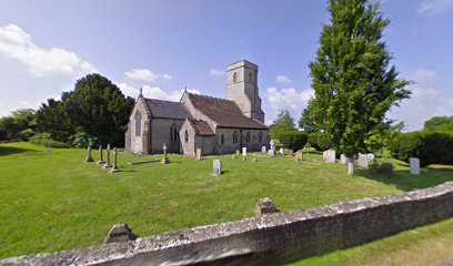
| Description | : | The stone building has Doulting stone dressings and slate or clay tile roofs. It consists of a three-bay nave, two-bay chancel and north aisle. The three-stage tower is supported by corner buttresses. There are three bells in the tower dating from the 15th and 17th centuries. The majority of fittings in the church are from the 19th century but it does have door arches, a piscina and ambry surviving from the original building. In the churchyard is an early 17th century chest tomb to the Danyell family. |
frequently asked questions (FAQ):
-
Where is Church of St Thomas of Canterbury?
Church of St Thomas of Canterbury is located at Lovington, South Somerset District ,Somerset ,England.
-
Church of St Thomas of Canterbury cemetery's updated grave count on graveviews.com?
0 memorials
-
Where are the coordinates of the Church of St Thomas of Canterbury?
Latitude: 51.0754000
Longitude: -2.5771000
Nearby Cemetories:
1. St Nicolas' Churchyard
North Barrow, South Somerset District, England
Coordinate: 51.0623705, -2.5605033
2. All Saint's Church
Alford, South Somerset District, England
Coordinate: 51.0916210, -2.5659300
3. St Peters Churchyard
East Lydford, Mendip District, England
Coordinate: 51.0789840, -2.6116080
4. St Marys Churchyard
East Lydford, Mendip District, England
Coordinate: 51.0789890, -2.6116890
5. Saint Mary's Churchyard
East Lydford, Mendip District, England
Coordinate: 51.0789630, -2.6117072
6. St Peter's Church
Hornblotton, Mendip District, England
Coordinate: 51.1037752, -2.5846439
7. St. Peter Churchyard
Lydford-on-Fosse, Mendip District, England
Coordinate: 51.0846000, -2.6231400
8. Castle Cary Cemetery
Castle Cary, South Somerset District, England
Coordinate: 51.0803800, -2.5223600
9. Holy Cross Churchyard
Babcary, South Somerset District, England
Coordinate: 51.0563609, -2.6268770
10. All Saints
Castle Cary, South Somerset District, England
Coordinate: 51.0865760, -2.5165400
11. St Andrew Churchyard
Ansford, South Somerset District, England
Coordinate: 51.0943350, -2.5180470
12. Saint Mary Magdalene Churchyard
Keinton Mandeville, South Somerset District, England
Coordinate: 51.0683291, -2.6471408
13. St Michael Churchyard
North Cadbury, South Somerset District, England
Coordinate: 51.0416670, -2.5213610
14. St. David's Churchyard
Barton St David, South Somerset District, England
Coordinate: 51.0828220, -2.6585470
15. Saint Barnabas Churchyard
Queen Camel, South Somerset District, England
Coordinate: 51.0225850, -2.5759270
16. St Mary Magdalene Churchyard
Ditcheat, Mendip District, England
Coordinate: 51.1250270, -2.5362010
17. St. Peter & St. Paul's Churchyard
Charlton Adam, South Somerset District, England
Coordinate: 51.0552350, -2.6647930
18. All Saints Churchyard
East Pennard, Mendip District, England
Coordinate: 51.1351890, -2.5773210
19. Blessed Virgin Mary Churchyard
Compton Pauncefoot, South Somerset District, England
Coordinate: 51.0336770, -2.5089430
20. St. Dunstan Churchyard
Baltonsborough, Mendip District, England
Coordinate: 51.1107200, -2.6557600
21. All Saints Churchyard
Kingweston, South Somerset District, England
Coordinate: 51.0793076, -2.6791489
22. Saint James Churchyard
West Bradley, Mendip District, England
Coordinate: 51.1293030, -2.6332386
23. Church of the Virgin Mary
Charlton Mackrell, South Somerset District, England
Coordinate: 51.0524210, -2.6743894
24. Church of the Holy Trinity
Bruton, South Somerset District, England
Coordinate: 51.1070450, -2.4843710