
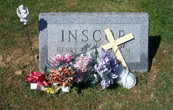

Emma Marie Phipps Inscor
| Birth | : | 8 Jun 1911 Independence, Grayson County, Virginia, USA |
| Death | : | 19 Feb 2000 Bel Air, Harford County, Maryland, USA |
| Burial | : | Old Town Cemetery, Sandwich, Barnstable County, USA |
| Coordinate | : | 41.7556992, -70.5011978 |
| Description | : | Emma Marie Inscor, age 88, of Darlington, Md., died Saturday, Feb. 19, 2000 at Mariner Health of Bel Air in Bel Air, Md. Mrs. Inscor was born on June 8, 1911 in Independence, the daughter of the late Harvey and Carrie Maude (Phipps) Rutherford. She moved to Harford County from Virginia in 1956. She worked at Walter''s Dairy Farm at Forest Hill, Md., from 1956 to 1964 and then at several other local farms. From 1972 to 1974 she worked at the Ballpark Diner, Street, Md. She enjoyed gardening. Mrs. Inscor was preceded in death by her husband,... Read More |
frequently asked questions (FAQ):
-
Where is Emma Marie Phipps Inscor's memorial?
Emma Marie Phipps Inscor's memorial is located at: Old Town Cemetery, Sandwich, Barnstable County, USA.
-
When did Emma Marie Phipps Inscor death?
Emma Marie Phipps Inscor death on 19 Feb 2000 in Bel Air, Harford County, Maryland, USA
-
Where are the coordinates of the Emma Marie Phipps Inscor's memorial?
Latitude: 41.7556992
Longitude: -70.5011978
Family Members:
Parent

Spouse

Siblings
Flowers:


Nearby Cemetories:
1. Old Town Cemetery
Sandwich, Barnstable County, USA
Coordinate: 41.7556992, -70.5011978
2. Freeman Cemetery
Sandwich, Barnstable County, USA
Coordinate: 41.7573013, -70.5083008
3. Bay View Cemetery
Sandwich, Barnstable County, USA
Coordinate: 41.7583008, -70.5102997
4. Saint Peters Cemetery
Sandwich, Barnstable County, USA
Coordinate: 41.7502480, -70.5079346
5. Mount Hope Cemetery
Sandwich, Barnstable County, USA
Coordinate: 41.7518997, -70.4850006
6. Almshouse Burial Ground
Sandwich, Barnstable County, USA
Coordinate: 41.7501000, -70.4847000
7. Saddle and Pillion Cemetery
Sagamore, Barnstable County, USA
Coordinate: 41.7672005, -70.5192032
8. Spring Hill Cemetery
Sandwich, Barnstable County, USA
Coordinate: 41.7487984, -70.4775009
9. Sagamore Cemetery
Bourne, Barnstable County, USA
Coordinate: 41.7714005, -70.5339966
10. Old Quaker Meeting House Cemetery at Spring Hill
Sandwich, Barnstable County, USA
Coordinate: 41.7463100, -70.4613060
11. Quaker Meeting House Cemetery
East Sandwich, Barnstable County, USA
Coordinate: 41.7469673, -70.4591064
12. Sandwich Town Cemetery
Sandwich, Barnstable County, USA
Coordinate: 41.7125300, -70.4909000
13. Cedarville Cemetery
East Sandwich, Barnstable County, USA
Coordinate: 41.7397804, -70.4428864
14. Bournedale Burying Hill
Bourne, Barnstable County, USA
Coordinate: 41.7741520, -70.5611730
15. Bournedale Herring Pond Indian Cemetery
Bourne, Barnstable County, USA
Coordinate: 41.7861900, -70.5658722
16. Herring Pond Wampanoag Indian Cemetery
Plymouth, Plymouth County, USA
Coordinate: 41.7867290, -70.5658940
17. Tobey Cemetery
Forestdale, Barnstable County, USA
Coordinate: 41.6972008, -70.4875031
18. Herring Pond Cemetery
Plymouth, Plymouth County, USA
Coordinate: 41.7971700, -70.5588800
19. Cedarville Cemetery
Plymouth, Plymouth County, USA
Coordinate: 41.8049736, -70.5560837
20. Forestdale Cemetery
Forestdale, Barnstable County, USA
Coordinate: 41.6903000, -70.5024033
21. Nightingale Cemetery
Plymouth, Plymouth County, USA
Coordinate: 41.8113400, -70.5588260
22. Bourne Village Cemetery
Bourne, Barnstable County, USA
Coordinate: 41.7425117, -70.5938110
23. Lakewood Cemetery
Plymouth, Plymouth County, USA
Coordinate: 41.8141260, -70.5567690
24. Bourne Family Cemetery #02
Bourne, Barnstable County, USA
Coordinate: 41.7577230, -70.6001190