
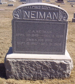
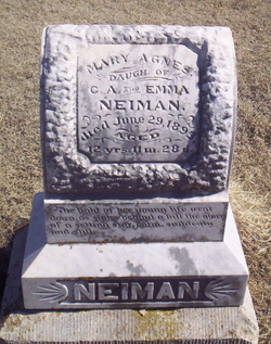
Emma Moreland Neiman
| Birth | : | 13 Sep 1857 Cedar County, Iowa, USA |
| Death | : | 31 Dec 1909 Newton, Harvey County, Kansas, USA |
| Burial | : | Chatham Hill Memorial Gardens, Cheraw, Chesterfield County, USA |
| Coordinate | : | 34.6719017, -79.9019012 |
| Plot | : | 3rd row east of center drive |
| Inscription | : | His wife |
| Description | : | Obituary The Tipton Advertiser January 20, 1910 Emma Moreland was born in Cedar County, Iowa, on the 13th day of September, 1857, where she lived until her marriage to Charles A. Neiman on the 11th day of March 1880. She then left her old home in Cedar County, Iowa, for her new home in Butler county, Kansas, where she has since lived with her husband and children, until she left last Wednesday for the Hospital at Newton, for the purpose of undergoing an operation from the effect of which she died December 31st, 1909. Six children were born to this... Read More |
frequently asked questions (FAQ):
-
Where is Emma Moreland Neiman's memorial?
Emma Moreland Neiman's memorial is located at: Chatham Hill Memorial Gardens, Cheraw, Chesterfield County, USA.
-
When did Emma Moreland Neiman death?
Emma Moreland Neiman death on 31 Dec 1909 in Newton, Harvey County, Kansas, USA
-
Where are the coordinates of the Emma Moreland Neiman's memorial?
Latitude: 34.6719017
Longitude: -79.9019012
Family Members:
Parent

Spouse

Siblings
Children
Flowers:


Nearby Cemetories:
1. Chatham Hill Memorial Gardens
Cheraw, Chesterfield County, USA
Coordinate: 34.6719017, -79.9019012
2. Foundry Hill Cemetery
Cheraw, Chesterfield County, USA
Coordinate: 34.6957350, -79.8998800
3. Fisher Hill Community Cemetery
Cheraw, Chesterfield County, USA
Coordinate: 34.6738360, -79.9319040
4. J. C. Broome Memorial Garden
Cheraw, Chesterfield County, USA
Coordinate: 34.6753830, -79.9346970
5. Old Saint Davids Episcopal Church Cemetery
Cheraw, Chesterfield County, USA
Coordinate: 34.6956140, -79.8794250
6. Pee Dee Union Baptist Church Cemetery
Cheraw, Chesterfield County, USA
Coordinate: 34.6968440, -79.8775160
7. Faith Freewill Baptist Church Cemetery
Cheraw, Chesterfield County, USA
Coordinate: 34.6717450, -79.9451980
8. Progressive Church of Our Lord Jesus Christ Cemete
Cheraw, Chesterfield County, USA
Coordinate: 34.6910300, -79.9387430
9. Erasmus Powe Family Cemetery
Cheraw, Chesterfield County, USA
Coordinate: 34.7041400, -79.8822950
10. Montrose Cemetery
Chesterfield County, USA
Coordinate: 34.6255989, -79.8842010
11. Prince Of Peace Church Cemetery
Cheraw, Chesterfield County, USA
Coordinate: 34.7076230, -79.9484660
12. Pleasant Grove United Methodist Church Cemetery
Cheraw, Chesterfield County, USA
Coordinate: 34.7048630, -79.9539520
13. Gillespie - Shipp Family Graveyard
Wallace, Marlboro County, USA
Coordinate: 34.7179060, -79.8657610
14. Wallace Baptist Church Cemetery
Wallace, Marlboro County, USA
Coordinate: 34.7199530, -79.8609130
15. Shields Cemetery
Cash, Chesterfield County, USA
Coordinate: 34.6157180, -79.8753370
16. Shield Cemetery
Cheraw, Chesterfield County, USA
Coordinate: 34.6156196, -79.8752721
17. Forest Pine Freewill Independent Church Cemetery
Cheraw, Chesterfield County, USA
Coordinate: 34.6324050, -79.9585820
18. Smithville Cemetery
Chesterfield County, USA
Coordinate: 34.7047005, -79.9669037
19. Mission of Faith Church Cemetery
Wallace, Marlboro County, USA
Coordinate: 34.7246090, -79.8598550
20. Pleasant Hill Baptist Church Cemetery
Cheraw, Chesterfield County, USA
Coordinate: 34.6372990, -79.9684310
21. Robinson Zion Church
Cheraw, Chesterfield County, USA
Coordinate: 34.7328090, -79.9323420
22. Howard Family Cemetery
Cheraw, Chesterfield County, USA
Coordinate: 34.6089410, -79.8780040
23. Cash Family Cemetery
Cash, Chesterfield County, USA
Coordinate: 34.6067210, -79.8742290
24. Greater White Creek Baptist Church Cemetery
Wallace, Marlboro County, USA
Coordinate: 34.7346600, -79.8667400