

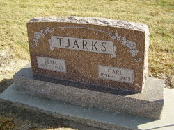
Erma Churches Tjarks
| Birth | : | 11 Jun 1897 Webster County, Nebraska, USA |
| Death | : | 21 Sep 1967 Hastings, Adams County, Nebraska, USA |
| Burial | : | St. Mary the Virgin Churchyard, Emborough, Mendip District, England |
| Coordinate | : | 51.2600970, -2.5539150 |
| Plot | : | SW section Lot 169 |
| Description | : | Tjarks, Services In Blue Hill Monday Mrs. Erma Tjarks, who was born in Webster County on June 11, 1897, passed away at the Mary Lanning Hospital in Hastings on September 21, 1967, after being hospitalized there for 22 days. She was the daughter of Mr. and Mrs. Fred Churches. The deceased made her home on a farm five miles southwest of Lawrence. Her husband, Carl, survives. Services were held Monday at two o’clock at the Merten-Butler Funeral Chapel with the Rev. Homer Clements officiating. Music was furnished by Mrs. Ralph Baird and Mrs. Wilbur Mohlman. Pallbearers were William Schuppan, Dale Kottwitz, Bernell Kottwitz,... Read More |
frequently asked questions (FAQ):
-
Where is Erma Churches Tjarks's memorial?
Erma Churches Tjarks's memorial is located at: St. Mary the Virgin Churchyard, Emborough, Mendip District, England.
-
When did Erma Churches Tjarks death?
Erma Churches Tjarks death on 21 Sep 1967 in Hastings, Adams County, Nebraska, USA
-
Where are the coordinates of the Erma Churches Tjarks's memorial?
Latitude: 51.2600970
Longitude: -2.5539150
Family Members:
Parent

Spouse
Siblings
Flowers:


Nearby Cemetories:
1. St. Mary the Virgin Churchyard
Emborough, Mendip District, England
Coordinate: 51.2600970, -2.5539150
2. Holy Trinity Churchyard
Binegar, Mendip District, England
Coordinate: 51.2425530, -2.5524812
3. St Mary The Virgin Churchyard
Ston Easton, Mendip District, England
Coordinate: 51.2788400, -2.5404390
4. Saint Mary the Virgin Church
Ston Easton, Mendip District, England
Coordinate: 51.2789610, -2.5407720
5. St Mary Magdalene Churchyard
Chewton Mendip, Mendip District, England
Coordinate: 51.2760790, -2.5800490
6. Downside Cemetery
Chilcompton, Mendip District, England
Coordinate: 51.2517300, -2.5152400
7. Christ Church, Downside
Chilcompton, Mendip District, England
Coordinate: 51.2515150, -2.5153030
8. Christ Church Churchyard
Mendip District, England
Coordinate: 51.2514920, -2.5151540
9. St John the Baptist Church Cemetery
Chilcompton, Mendip District, England
Coordinate: 51.2693960, -2.5073780
10. St James Churchyard
Ashwick, Mendip District, England
Coordinate: 51.2320800, -2.5229500
11. Saint Mary the Virgin Churchyard
Litton, Mendip District, England
Coordinate: 51.2899860, -2.5838440
12. Downside Abbey
Stratton-on-the-Fosse, Mendip District, England
Coordinate: 51.2544000, -2.4943000
13. St. Benedict's Churchyard
Stratton-on-the-Fosse, Mendip District, England
Coordinate: 51.2560684, -2.4913545
14. Saint Vigor Churchyard
Stratton-on-the-Fosse, Mendip District, England
Coordinate: 51.2552000, -2.4896000
15. St. John the Baptist Churchyard
Farrington Gurney, Bath and North East Somerset Unitary Authority, England
Coordinate: 51.2993710, -2.5248000
16. St. Andrew's Churchyard
Holcombe, Mendip District, England
Coordinate: 51.2547850, -2.4760280
17. St. John the Baptist Churchyard
Midsomer Norton, Bath and North East Somerset Unitary Authority, England
Coordinate: 51.2870310, -2.4842190
18. Saint John the Evangelist
East Horrington, Mendip District, England
Coordinate: 51.2180000, -2.6006900
19. St Margarets Churchyard
Hinton Blewett, Bath and North East Somerset Unitary Authority, England
Coordinate: 51.3104000, -2.5834000
20. St. James' Churchyard
Cameley, Bath and North East Somerset Unitary Authority, England
Coordinate: 51.3158560, -2.5606190
21. Church of the Holy Trinity
Paulton, Bath and North East Somerset Unitary Authority, England
Coordinate: 51.3074740, -2.5033500
22. St Michael & All Angels
Stoke St Michael, Mendip District, England
Coordinate: 51.2208300, -2.4819900
23. Paulton Cemetery
Paulton, Bath and North East Somerset Unitary Authority, England
Coordinate: 51.3095671, -2.4988841
24. Saint Laurence Churchyard
East Harptree, Bath and North East Somerset Unitary Authority, England
Coordinate: 51.3011730, -2.6245740