| Birth | : | 3 Apr 1925 Burkittsville, Frederick County, Maryland, USA |
| Death | : | 6 Jan 2006 Frederick County, Maryland, USA |
| Burial | : | Dana United Methodist Church Cemetery, Dana, Henderson County, USA |
| Coordinate | : | 35.3367271, -82.3744049 |
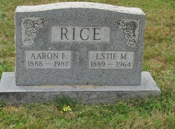
| Description | : | Erma Leah Rice Hooper Black was born on April 3, 1925 in Burkittsville a daughter of Aaron Franklin and Estie Mae Guyton Rice and was twice married, first to Grayson Oliver Hooper who she married on April 25, 1953 and predeceased her in an automobile accident, May 31, 1956 and second to Orville Clevland Black, who she married on April 16, 1961 and survives her. She had been employed for a number of years with the Union Bridge Clothing Company and the Thurmont Shoe Company as a seamstress. Erma was a member of the Monocacy Church Of... Read More |
frequently asked questions (FAQ):
-
Where is Erma Leah Rice Black's memorial?
Erma Leah Rice Black's memorial is located at: Dana United Methodist Church Cemetery, Dana, Henderson County, USA.
-
When did Erma Leah Rice Black death?
Erma Leah Rice Black death on 6 Jan 2006 in Frederick County, Maryland, USA
-
Where are the coordinates of the Erma Leah Rice Black's memorial?
Latitude: 35.3367271
Longitude: -82.3744049
Family Members:
Parent
Spouse
Siblings
Children
Flowers:
Nearby Cemetories:
1. Dana United Methodist Church Cemetery
Dana, Henderson County, USA
Coordinate: 35.3367271, -82.3744049
2. Dana Baptist Church Cemetery
Dana, Henderson County, USA
Coordinate: 35.3395300, -82.3729300
3. Refuge Baptist Church Cemetery
Dana, Henderson County, USA
Coordinate: 35.3288002, -82.3751984
4. Hill Family Cemetery
Dana, Henderson County, USA
Coordinate: 35.3416300, -82.3652940
5. Basiewicz Family Cemetery
Dana, Henderson County, USA
Coordinate: 35.3343700, -82.3603700
6. Stepp Round Hill Cemetery
Hendersonville, Henderson County, USA
Coordinate: 35.3367483, -82.3464429
7. Stepp Cemetery
Hendersonville, Henderson County, USA
Coordinate: 35.3365000, -82.3464000
8. Hammett Family Cemetery
Upward, Henderson County, USA
Coordinate: 35.3090400, -82.3868630
9. Union Hill Holiness Baptist Church Cemetery
Hendersonville, Henderson County, USA
Coordinate: 35.3522000, -82.3395000
10. Tracy Grove Baptist Church
Henderson County, USA
Coordinate: 35.3142014, -82.4045029
11. Kings Grove Church Cemetery
Henderson County, USA
Coordinate: 35.3716740, -82.3685470
12. Jones Family Cemetery at Upward
Upward, Henderson County, USA
Coordinate: 35.3022003, -82.3855972
13. Bethel Wesleyan Church Cemetery
Henderson County, USA
Coordinate: 35.3157234, -82.4103165
14. Reese Bradley Cemetery
Dana, Henderson County, USA
Coordinate: 35.3386500, -82.3294800
15. Fair Haven Baptist Church Cemetery
Hendersonville, Henderson County, USA
Coordinate: 35.3447800, -82.4203100
16. Jones Cemetery at Sugarloaf
Henderson County, USA
Coordinate: 35.3669014, -82.3321991
17. Moores Grove Methodist Cemetery
Henderson County, USA
Coordinate: 35.3488007, -82.4318008
18. Seagle Cemetery
Henderson County, USA
Coordinate: 35.3553009, -82.4300003
19. Ebenezer Baptist Church Cemetery
Hendersonville, Henderson County, USA
Coordinate: 35.3498001, -82.4326019
20. Mills Cemetery
Henderson County, USA
Coordinate: 35.3863860, -82.3652670
21. Fruitland Cemetery
Henderson County, USA
Coordinate: 35.3833008, -82.4019012
22. Gilbert-Justus Family Cemetery
Upward, Henderson County, USA
Coordinate: 35.2861000, -82.3894380
23. Forest Lawn Memorial Park
Henderson County, USA
Coordinate: 35.3225403, -82.4362411
24. Edney-Coston Cemetery
Edneyville, Henderson County, USA
Coordinate: 35.3895250, -82.3550190


