
| Memorials | : | 0 |
| Location | : | Upward, Henderson County, USA |
| Coordinate | : | 35.2861000, -82.3894380 |
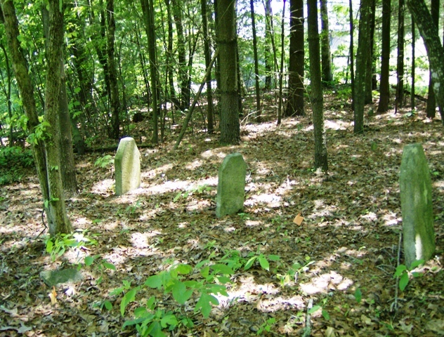
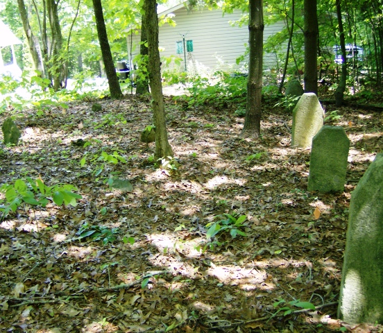
| Description | : | Located behind homes off Ridgeway Drive in the Upward community. Turn on Howard Gap Loop Road from Crest Road. Turn right on Ridgeway Drive. The old wagon road access to the cemetery is between 30 Ridgeway Drive and 60 Ridgeway Drive. The cemetery is in a subdivision, in the backyard of several houses, bordering a horse pasture, with no access without crossing private property. The cemetery is on the old homestead of William Justus, according to deeds in the Henderson County Courthouse. In 1901, the Justus descendants conveyed the land containing the cemetery to Caroline Gilbert, who was living... Read More |
frequently asked questions (FAQ):
-
Where is Gilbert-Justus Family Cemetery?
Gilbert-Justus Family Cemetery is located at Upward, Henderson County ,North Carolina ,USA.
-
Gilbert-Justus Family Cemetery cemetery's updated grave count on graveviews.com?
0 memorials
-
Where are the coordinates of the Gilbert-Justus Family Cemetery?
Latitude: 35.2861000
Longitude: -82.3894380
Nearby Cemetories:
1. Jones Family Cemetery at Upward
Upward, Henderson County, USA
Coordinate: 35.3022003, -82.3855972
2. Oak Grove Baptist Church Cemetery
East Flat Rock, Henderson County, USA
Coordinate: 35.2729000, -82.4031580
3. Hammett Family Cemetery
Upward, Henderson County, USA
Coordinate: 35.3090400, -82.3868630
4. Anders Cemetery
East Flat Rock, Henderson County, USA
Coordinate: 35.2654700, -82.4064300
5. Tracy Grove Baptist Church
Henderson County, USA
Coordinate: 35.3142014, -82.4045029
6. Oakland Cemetery
East Flat Rock, Henderson County, USA
Coordinate: 35.2835999, -82.4302979
7. Bethel Wesleyan Church Cemetery
Henderson County, USA
Coordinate: 35.3157234, -82.4103165
8. Pinecrest Presbyterian Church Memorial Garden
Flat Rock, Henderson County, USA
Coordinate: 35.2822100, -82.4426360
9. Refuge Baptist Church Cemetery
Dana, Henderson County, USA
Coordinate: 35.3288002, -82.3751984
10. Saint John In the Wilderness Cemetery
Flat Rock, Henderson County, USA
Coordinate: 35.2821170, -82.4435670
11. Fortune-Kuykendall Cemetery
Zirconia, Henderson County, USA
Coordinate: 35.2424000, -82.4032000
12. Dana United Methodist Church Cemetery
Dana, Henderson County, USA
Coordinate: 35.3367271, -82.3744049
13. Mud Creek Baptist Church Cemetery
Flat Rock, Henderson County, USA
Coordinate: 35.2905998, -82.4536972
14. Forest Lawn Memorial Park
Henderson County, USA
Coordinate: 35.3225403, -82.4362411
15. Saluda City Cemetery
Saluda, Polk County, USA
Coordinate: 35.2438600, -82.3505400
16. Basiewicz Family Cemetery
Dana, Henderson County, USA
Coordinate: 35.3343700, -82.3603700
17. Dana Baptist Church Cemetery
Dana, Henderson County, USA
Coordinate: 35.3395300, -82.3729300
18. Ward Family Cemetery
Henderson County, USA
Coordinate: 35.2308780, -82.4049850
19. Hill Family Cemetery
Dana, Henderson County, USA
Coordinate: 35.3416300, -82.3652940
20. Hill Mausoleum
Flat Rock, Henderson County, USA
Coordinate: 35.2630638, -82.4577080
21. Crossroads Baptist Church Cemetery
Zirconia, Henderson County, USA
Coordinate: 35.2287090, -82.4154320
22. Stepp Cemetery
Hendersonville, Henderson County, USA
Coordinate: 35.3365000, -82.3464000
23. Stepp Round Hill Cemetery
Hendersonville, Henderson County, USA
Coordinate: 35.3367483, -82.3464429
24. Mountain View Baptist Church Cemetery
Tuxedo, Henderson County, USA
Coordinate: 35.2325000, -82.4285000