
| Birth | : | 26 Jan 1913 Saint Joseph, Cloud County, Kansas, USA |
| Death | : | 15 Feb 2011 Clay Center, Clay County, Kansas, USA |
| Burial | : | Mount Calvary Cemetery, Clyde, Cloud County, USA |
| Coordinate | : | 39.5917015, -97.4143982 |
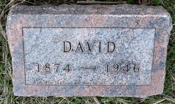
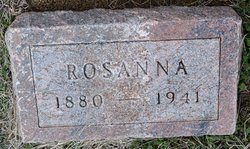
| Description | : | Esther A. Provost was born on Jan. 26, 1913 in St. Joseph, KS to David & Rosanna (Balthazor) Girard. She passed from this life on Tues., Feb. 15, 2011 at the Presbyterian Manor, Clay Center, KS at the age of 98. Esther married William "Bill" Provost on Oct. 8, 1935 at St. Joseph Catholic Church, St. Joseph, KS. He preceded her in death on March 26, 1985. They farmed for six years and then moved to Clyde. Esther will be remembered for her kindness and willingness to help. Although she never had children, she was a mother or grandmother to... Read More |
frequently asked questions (FAQ):
-
Where is Esther A. Girard Provost's memorial?
Esther A. Girard Provost's memorial is located at: Mount Calvary Cemetery, Clyde, Cloud County, USA.
-
When did Esther A. Girard Provost death?
Esther A. Girard Provost death on 15 Feb 2011 in Clay Center, Clay County, Kansas, USA
-
Where are the coordinates of the Esther A. Girard Provost's memorial?
Latitude: 39.5917015
Longitude: -97.4143982
Family Members:
Parent
Spouse

Siblings

Flowers:


Nearby Cemetories:
1. Mount Calvary Cemetery
Clyde, Cloud County, USA
Coordinate: 39.5917015, -97.4143982
2. Mount Hope Cemetery
Clyde, Cloud County, USA
Coordinate: 39.5969009, -97.4116974
3. Cedar Grove Cemetery
Clyde, Cloud County, USA
Coordinate: 39.5494003, -97.4056015
4. Pleasant View Cemetery
Ames, Cloud County, USA
Coordinate: 39.5346985, -97.4431000
5. Walnut Grove Cemetery
Cloud County, USA
Coordinate: 39.5699997, -97.4993973
6. Saint Joseph Cemetery
Saint Joseph, Cloud County, USA
Coordinate: 39.5074941, -97.4022328
7. Agenda Cemetery
Agenda, Republic County, USA
Coordinate: 39.6761017, -97.4336014
8. Green Mound Cemetery
Rice, Cloud County, USA
Coordinate: 39.5248450, -97.5081630
9. Hollis Cemetery
Cloud County, USA
Coordinate: 39.6383018, -97.5361023
10. Beck Family Cemetery
Agenda, Republic County, USA
Coordinate: 39.6818000, -97.4863000
11. Rice Cemetery
Rice, Cloud County, USA
Coordinate: 39.5614014, -97.5552979
12. Nelson Cemetery
Rice, Cloud County, USA
Coordinate: 39.5257988, -97.5410995
13. Riverdale Cemetery
Clay County, USA
Coordinate: 39.5106010, -97.2930984
14. Saint Peters Cemetery
Aurora, Cloud County, USA
Coordinate: 39.4763985, -97.5180969
15. Princeville Cemetery
Aurora, Cloud County, USA
Coordinate: 39.4672012, -97.5010986
16. Iwacura Cemetery
Morganville, Clay County, USA
Coordinate: 39.4550000, -97.3510000
17. Union Cemetery
Wayne, Republic County, USA
Coordinate: 39.6977997, -97.5457993
18. Willoughby Cemetery
Agenda, Republic County, USA
Coordinate: 39.7402992, -97.4244003
19. French Presbyterian Church Cemetery
Cloud County, USA
Coordinate: 39.4395200, -97.4148290
20. Gotland Cemetery
Sibley Township, Cloud County, USA
Coordinate: 39.6091995, -97.6125031
21. Sherman Cemetery
Morganville, Clay County, USA
Coordinate: 39.5316300, -97.2243700
22. Zion Cemetery
Agenda, Republic County, USA
Coordinate: 39.6749992, -97.5939026
23. Rose Hill Cemetery
Wayne, Republic County, USA
Coordinate: 39.7111015, -97.5661011
24. Minersville Cemetery
Talmo, Republic County, USA
Coordinate: 39.6568330, -97.6229250