

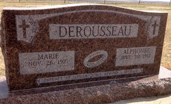
Marie Dorothy Girard Derousseau
| Birth | : | 26 Nov 1921 Saint Joseph, Cloud County, Kansas, USA |
| Death | : | 17 Jun 2018 Clay Center, Clay County, Kansas, USA |
| Burial | : | Saint Joseph Cemetery, Saint Joseph, Cloud County, USA |
| Coordinate | : | 39.5074941, -97.4022328 |
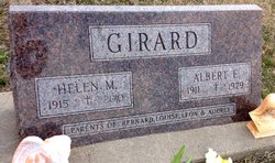
| Inscription | : | Married Mar. 4, 1946 Parents of Adrian, Joyce, Armand, Michael |
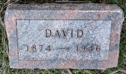
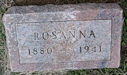
| Description | : | Chaput-Buoy Funeral Home Marie Dorothy (Girard) Derousseau, age 96, entered into rest on Sunday, June 17, 2018 at the Clay Center Presbyterian Manor, Clay Center, Kansas. She was born in St. Joseph, Kansas on November 26, 1921 to the late David and Rosanna (Balthazor) Girard. She graduated from Aurora Catholic High School in 1940. On March 4, 1946 she married Alphonse Derousseau at St. John the Baptist Catholic Church in Clyde, Kansas by Father Henry Sporenberg. She was a homemaker. She was a former CCD teacher, Altar Society President, store clerk, held offices in the Parish Deanery, and Diocesan... Read More |
frequently asked questions (FAQ):
-
Where is Marie Dorothy Girard Derousseau's memorial?
Marie Dorothy Girard Derousseau's memorial is located at: Saint Joseph Cemetery, Saint Joseph, Cloud County, USA.
-
When did Marie Dorothy Girard Derousseau death?
Marie Dorothy Girard Derousseau death on 17 Jun 2018 in Clay Center, Clay County, Kansas, USA
-
Where are the coordinates of the Marie Dorothy Girard Derousseau's memorial?
Latitude: 39.5074941
Longitude: -97.4022328
Family Members:
Parent
Spouse
Siblings

Flowers:


Nearby Cemetories:
1. Saint Joseph Cemetery
Saint Joseph, Cloud County, USA
Coordinate: 39.5074941, -97.4022328
2. Pleasant View Cemetery
Ames, Cloud County, USA
Coordinate: 39.5346985, -97.4431000
3. Cedar Grove Cemetery
Clyde, Cloud County, USA
Coordinate: 39.5494003, -97.4056015
4. Iwacura Cemetery
Morganville, Clay County, USA
Coordinate: 39.4550000, -97.3510000
5. French Presbyterian Church Cemetery
Cloud County, USA
Coordinate: 39.4395200, -97.4148290
6. Green Mound Cemetery
Rice, Cloud County, USA
Coordinate: 39.5248450, -97.5081630
7. Riverdale Cemetery
Clay County, USA
Coordinate: 39.5106010, -97.2930984
8. Mount Calvary Cemetery
Clyde, Cloud County, USA
Coordinate: 39.5917015, -97.4143982
9. Princeville Cemetery
Aurora, Cloud County, USA
Coordinate: 39.4672012, -97.5010986
10. Mount Hope Cemetery
Clyde, Cloud County, USA
Coordinate: 39.5969009, -97.4116974
11. Saint Peters Cemetery
Aurora, Cloud County, USA
Coordinate: 39.4763985, -97.5180969
12. Walnut Grove Cemetery
Cloud County, USA
Coordinate: 39.5699997, -97.4993973
13. Nelson Cemetery
Rice, Cloud County, USA
Coordinate: 39.5257988, -97.5410995
14. Bloom Cemetery
Morganville, Clay County, USA
Coordinate: 39.4519005, -97.2778015
15. Lincoln Cemetery
Clay Center, Clay County, USA
Coordinate: 39.4230995, -97.2930984
16. Sulphur Springs Cemetery
Aurora, Cloud County, USA
Coordinate: 39.4086610, -97.4986840
17. Rice Cemetery
Rice, Cloud County, USA
Coordinate: 39.5614014, -97.5552979
18. Sherman Cemetery
Morganville, Clay County, USA
Coordinate: 39.5316300, -97.2243700
19. Smith Grave
Miltonvale, Cloud County, USA
Coordinate: 39.3645300, -97.4308700
20. Hollis Cemetery
Cloud County, USA
Coordinate: 39.6383018, -97.5361023
21. Norwegian Lutheran Cemetery
Clay Center, Clay County, USA
Coordinate: 39.5027900, -97.1828200
22. Agenda Cemetery
Agenda, Republic County, USA
Coordinate: 39.6761017, -97.4336014
23. Morganville City Cemetery
Morganville, Clay County, USA
Coordinate: 39.4733009, -97.1819000
24. Miltonvale Cemetery
Miltonvale, Cloud County, USA
Coordinate: 39.3358002, -97.4447021