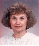
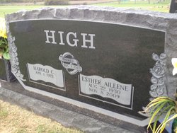
Esther Aileene LeBow High
| Birth | : | 22 Aug 1930 Purdy, Madison County, Arkansas, USA |
| Death | : | 8 Nov 2009 Springdale, Washington County, Arkansas, USA |
| Burial | : | First Mennonite Cemetery, Moundridge, McPherson County, USA |
| Coordinate | : | 38.1885090, -97.5094070 |
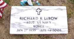
| Description | : | Aileene High 79 of Springdale went to be with the Lord November 8, 2009 at Circle of Life Hospice in Springdale. She was born August 22, 1930 in Purdy, AR to William & Bonnie Spradling LeBow. She was a homemaker and member of First Baptist Church where she sang in the choir for many years. She also worked as a secretary for Jones Truck Line, Jones Elementary and Lee Elementry. She was preceded in death by her parents, one brother, Richard LeBow and one great grandson Peyton Thomas. She is survived by her husband Harold High whom she married August 7, 1948.... Read More |
frequently asked questions (FAQ):
-
Where is Esther Aileene LeBow High's memorial?
Esther Aileene LeBow High's memorial is located at: First Mennonite Cemetery, Moundridge, McPherson County, USA.
-
When did Esther Aileene LeBow High death?
Esther Aileene LeBow High death on 8 Nov 2009 in Springdale, Washington County, Arkansas, USA
-
Where are the coordinates of the Esther Aileene LeBow High's memorial?
Latitude: 38.1885090
Longitude: -97.5094070
Family Members:
Parent
Spouse
Siblings
Flowers:
Nearby Cemetories:
1. First Mennonite Cemetery
Moundridge, McPherson County, USA
Coordinate: 38.1885090, -97.5094070
2. West Zion Cemetery
Moundridge, McPherson County, USA
Coordinate: 38.2028008, -97.5372009
3. Mound Township Cemetery
Moundridge, McPherson County, USA
Coordinate: 38.2028008, -97.5378036
4. Schlender Cemetery
Harvey County, USA
Coordinate: 38.1669006, -97.5374985
5. Freedom Baptist Church Cemetery
McPherson County, USA
Coordinate: 38.2027400, -97.4362500
6. Hopefield Church Cemetery
Moundridge, McPherson County, USA
Coordinate: 38.2105180, -97.5858040
7. Farnsworth-Cook Cemetery
Halstead, Harvey County, USA
Coordinate: 38.1233600, -97.4992200
8. Garden Valley Cemetery
Harvey County, USA
Coordinate: 38.1232147, -97.4998856
9. Garden Community Church Cemetery
Halstead, Harvey County, USA
Coordinate: 38.1225900, -97.5188600
10. Lohrentz Cemetery
Harvey County, USA
Coordinate: 38.1518374, -97.5843430
11. Hesston Cemetery
Hesston, Harvey County, USA
Coordinate: 38.1448900, -97.4402400
12. Whitestone Mennonite Church Columbarium
Hesston, Harvey County, USA
Coordinate: 38.1458950, -97.4297920
13. Eden Mennonite Church Cemetery
Moundridge, McPherson County, USA
Coordinate: 38.2329890, -97.5940630
14. German Evangelical Lutheran Cemetery
Meridian Township, McPherson County, USA
Coordinate: 38.2567150, -97.4267420
15. Meridian Cemetery
McPherson County, USA
Coordinate: 38.1741028, -97.3904722
16. Lone Tree Cemetery
Moundridge, McPherson County, USA
Coordinate: 38.2846985, -97.5002975
17. Emmanuel Bible Church Cemetery
Moundridge, McPherson County, USA
Coordinate: 38.2868200, -97.5264200
18. Immanuel Lutheran Church Cemetery
Canton, McPherson County, USA
Coordinate: 38.2755330, -97.4473030
19. Garden View Mennonite Church Cemetery
Hesston, Harvey County, USA
Coordinate: 38.0874400, -97.5128900
20. Anna Schmidt Cemetery
Meridian Township, McPherson County, USA
Coordinate: 38.2283911, -97.3893937
21. Church of God of The Firstborn Cemetery
Emma Township, Harvey County, USA
Coordinate: 38.0940100, -97.4269800
22. Eastlawn Cemetery
Zimmerdale, Harvey County, USA
Coordinate: 38.1151100, -97.3902900
23. Knopp Cemetery
West Branch Township, Marion County, USA
Coordinate: 38.2003140, -97.3540140
24. Highland Cemetery
Newton, Harvey County, USA
Coordinate: 38.1440540, -97.3531320

