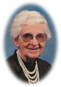
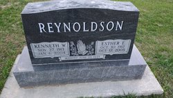
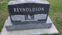
Esther E. Kemper Reynoldson
| Birth | : | 30 Oct 1912 Saint Edward, Boone County, Nebraska, USA |
| Death | : | 12 Oct 2005 Albion, Boone County, Nebraska, USA |
| Burial | : | Emerson Cemetery, Emerson, Mills County, USA |
| Coordinate | : | 41.0325012, -95.4021988 |
| Description | : | Daughter of Charles & Mary (Meyer) Kemper. Married to Kenneth Reynoldson on 6-29-1949 at San Diego, CA. She graduated from St. Edward High School in 1931 and then attended Midland Lutheran College in Fremont and Wesleyan University in Lincoln and received her teaching degree. She also attended the University of San Diego, CA. She taught school for 33 years |
frequently asked questions (FAQ):
-
Where is Esther E. Kemper Reynoldson's memorial?
Esther E. Kemper Reynoldson's memorial is located at: Emerson Cemetery, Emerson, Mills County, USA.
-
When did Esther E. Kemper Reynoldson death?
Esther E. Kemper Reynoldson death on 12 Oct 2005 in Albion, Boone County, Nebraska, USA
-
Where are the coordinates of the Esther E. Kemper Reynoldson's memorial?
Latitude: 41.0325012
Longitude: -95.4021988
Family Members:
Spouse
Flowers:
Nearby Cemetories:
1. Emerson Cemetery
Emerson, Mills County, USA
Coordinate: 41.0325012, -95.4021988
2. Lowens Cemetery
Garfield Township, Montgomery County, USA
Coordinate: 41.0527728, -95.3758292
3. North Grove Cemetery
Hastings, Mills County, USA
Coordinate: 41.0161018, -95.4618988
4. Hastings Cemetery
Hastings, Mills County, USA
Coordinate: 41.0097008, -95.4993973
5. Walnut Cemetery
Montgomery County, USA
Coordinate: 40.9519005, -95.3741989
6. South Grove Cemetery
Mills County, USA
Coordinate: 40.9775009, -95.4931030
7. Salem Cemetery
Red Oak, Montgomery County, USA
Coordinate: 40.9733009, -95.3088989
8. Wearin Cemetery
Malvern, Mills County, USA
Coordinate: 41.0395000, -95.5313000
9. Farm Creek Cemetery
Henderson, Mills County, USA
Coordinate: 41.1319008, -95.4186020
10. Wesley Chapel Cemetery
Henderson, Mills County, USA
Coordinate: 41.1019249, -95.4987793
11. Cotten Cemetery
Mills County, USA
Coordinate: 41.0845000, -95.5167000
12. Saylers Farm Cemetery
Henderson, Mills County, USA
Coordinate: 41.1083300, -95.4919440
13. Parker Cemetery
White Cloud, Mills County, USA
Coordinate: 40.9737649, -95.5184363
14. David Farm Cemetery
West Township, Montgomery County, USA
Coordinate: 40.9249960, -95.3766593
15. Gomer Cemetery
Wales, Montgomery County, USA
Coordinate: 41.1171989, -95.3082962
16. Saint Marys Cemetery
Red Oak, Montgomery County, USA
Coordinate: 41.0447006, -95.2275009
17. Buckner Cemetery
Wales, Montgomery County, USA
Coordinate: 41.1595600, -95.3440700
18. Hewitt Cemetery
Red Oak, Montgomery County, USA
Coordinate: 40.9850006, -95.2335968
19. Evergreen Cemetery
Red Oak, Montgomery County, USA
Coordinate: 41.0228004, -95.2205963
20. Malvern Cemetery
Malvern, Mills County, USA
Coordinate: 40.9886017, -95.5785980
21. Monroe Cemetery
Imogene, Fremont County, USA
Coordinate: 40.8880997, -95.4222031
22. Center Ridge Cemetery
Montgomery County, USA
Coordinate: 41.1452141, -95.2787018
23. L Laire Property Cemetery (Defunct)
Sherman Township, Montgomery County, USA
Coordinate: 41.0958257, -95.2224927
24. Saint Clair Cemetery
Red Oak Township, Montgomery County, USA
Coordinate: 41.0598400, -95.2049810


