
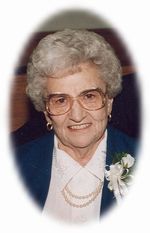
Ethel G Thomasson Shaw
| Birth | : | 15 Aug 1912 St. Francois County, Missouri, USA |
| Death | : | 14 Jun 2005 Cape Girardeau, Cape Girardeau County, Missouri, USA |
| Burial | : | St John the Evangelist Churchyard, Hildenborough, Tonbridge and Malling Borough, England |
| Coordinate | : | 51.2174100, 0.2391660 |
| Description | : | Mrs. Ethel G. 'Thomasson' Shaw, 92, formerly of Farmington, passed away June 14, 2005, at The Cape Girardeau Lutheran Home. Ethel was born on August 15, 1912, in St. Francois County, to Carl and Ada 'Cook' Thomasson. She was also preceded in death by her husband, Glen J. Shaw (1999); 3 Sisters: Alma Kerlagan; Edith Welland, and Mabel Carvick; 2 Brothers: Shelton and Paul Thomasson. Also, two Sisters-In-Law: Ruth Moore and Clara Shaw. Ethel was a member of Memorial United Methodist Church of Farmington. Survivors Include two Sons: Carl (and Carol) Shaw, of Cape... Read More |
frequently asked questions (FAQ):
-
Where is Ethel G Thomasson Shaw's memorial?
Ethel G Thomasson Shaw's memorial is located at: St John the Evangelist Churchyard, Hildenborough, Tonbridge and Malling Borough, England.
-
When did Ethel G Thomasson Shaw death?
Ethel G Thomasson Shaw death on 14 Jun 2005 in Cape Girardeau, Cape Girardeau County, Missouri, USA
-
Where are the coordinates of the Ethel G Thomasson Shaw's memorial?
Latitude: 51.2174100
Longitude: 0.2391660
Family Members:
Spouse

Flowers:


Nearby Cemetories:
1. St John the Evangelist Churchyard
Hildenborough, Tonbridge and Malling Borough, England
Coordinate: 51.2174100, 0.2391660
2. Hildenborough War Memorial
Hildenborough, Tonbridge and Malling Borough, England
Coordinate: 51.2175827, 0.2372410
3. St. Mary's Churchyard
Leigh, Sevenoaks District, England
Coordinate: 51.1977660, 0.2151510
4. Tonbridge Cemetery
Tonbridge, Tonbridge and Malling Borough, England
Coordinate: 51.2057762, 0.2772440
5. St. Margaret's Churchyard
Underriver, Sevenoaks District, England
Coordinate: 51.2458191, 0.2291520
6. Tonbridge Castle
Tonbridge, Tonbridge and Malling Borough, England
Coordinate: 51.1987000, 0.2764000
7. St Peter and St Paul Church
Tonbridge, Tonbridge and Malling Borough, England
Coordinate: 51.1977660, 0.2764630
8. St Stephens
Tonbridge, Tonbridge and Malling Borough, England
Coordinate: 51.1893961, 0.2687135
9. St Giles Churchyard
Shipbourne, Tonbridge and Malling Borough, England
Coordinate: 51.2471700, 0.2786090
10. St Luke Churchyard
Chiddingstone Causeway, Sevenoaks District, England
Coordinate: 51.1974910, 0.1758540
11. Ightham Mote
Ightham, Tonbridge and Malling Borough, England
Coordinate: 51.2584610, 0.2695830
12. St. Lawrence Churchyard
Bidborough, Tunbridge Wells Borough, England
Coordinate: 51.1666950, 0.2371870
13. Southborough War Memorial
Southborough, Tunbridge Wells Borough, England
Coordinate: 51.1639214, 0.2528920
14. Plaxtol Parish Churchyard
Plaxtol, Tonbridge and Malling Borough, England
Coordinate: 51.2593498, 0.2945710
15. Plaxtol War Memorial
Plaxtol, Tonbridge and Malling Borough, England
Coordinate: 51.2592888, 0.2948450
16. St. Peter's Churchyard
Southborough, Tunbridge Wells Borough, England
Coordinate: 51.1626549, 0.2520690
17. St. John the Baptist Churchyard
Penshurst, Sevenoaks District, England
Coordinate: 51.1735240, 0.1834540
18. Holy Trinity Churchyard
Crockham Hill, Sevenoaks District, England
Coordinate: 51.1982790, 0.1538090
19. St Nicholas Churchyard
Sevenoaks, Sevenoaks District, England
Coordinate: 51.2673310, 0.1933100
20. St. Lawrence Churchyard
Seal Chart, Sevenoaks District, England
Coordinate: 51.2742910, 0.2537250
21. Southborough Cemetery
Southborough, Tunbridge Wells Borough, England
Coordinate: 51.1592860, 0.2420140
22. All Saints Churchyard
Tudeley, Tunbridge Wells Borough, England
Coordinate: 51.1848510, 0.3186970
23. Chiddingstone Churchyard Extension
Chiddingstone, Sevenoaks District, England
Coordinate: 51.1861590, 0.1488930
24. Sevenoaks War Memorial
Sevenoaks, Sevenoaks District, England
Coordinate: 51.2761078, 0.1927860