

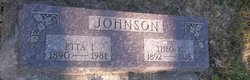
Etta Ione Larson Johnson
| Birth | : | 15 Feb 1890 Stockholm Township, Crawford County, Iowa, USA |
| Death | : | 24 Feb 1981 Odebolt, Sac County, Iowa, USA |
| Burial | : | Bolton Cemetery, Bolton upon Dearne, Metropolitan Borough of Barnsley, England |
| Coordinate | : | 53.5209050, -1.3172860 |
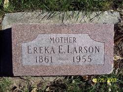
| Description | : | Etta Ione Larson Birth: 15 FEB 1890 in Stockholm township, Crawford county, Iowa Death: 24 FEB 1981 in Odebolt, Sac county, Iowa Burial: Kiron Cemetery, Kiron, Iowa Father: Carl Alexander Johannesson Larson b: 10 DEC 1854 in Skaftarp Landbogård, Rydaholm, Småland, F, SE Mother: Christina Ereka Emily Erickson b: 22 OCT 1861 in Gromstad, Sundvall Trakt, Medelpad, Y, SE Marriage 1 Carl Theodore Johnson b: 7 OCT 1892 in Hayes township, Ida county, Iowa Married: 16 SEP 1916 ------------- |
frequently asked questions (FAQ):
-
Where is Etta Ione Larson Johnson's memorial?
Etta Ione Larson Johnson's memorial is located at: Bolton Cemetery, Bolton upon Dearne, Metropolitan Borough of Barnsley, England.
-
When did Etta Ione Larson Johnson death?
Etta Ione Larson Johnson death on 24 Feb 1981 in Odebolt, Sac County, Iowa, USA
-
Where are the coordinates of the Etta Ione Larson Johnson's memorial?
Latitude: 53.5209050
Longitude: -1.3172860
Family Members:
Parent
Spouse
Siblings

Children
Flowers:


Nearby Cemetories:
1. Bolton Cemetery
Bolton upon Dearne, Metropolitan Borough of Barnsley, England
Coordinate: 53.5209050, -1.3172860
2. St. John the Baptist Churchyard
Adwick-on-Dearne, Metropolitan Borough of Doncaster, England
Coordinate: 53.5080520, -1.2924120
3. Thurnscoe Cemetery
Thurnscoe, Metropolitan Borough of Barnsley, England
Coordinate: 53.5423000, -1.3248700
4. St Helen Churchyard
Thurnscoe, Metropolitan Borough of Barnsley, England
Coordinate: 53.5452600, -1.3222850
5. All Saints Churchyard
Wath-upon-Dearne, Metropolitan Borough of Rotherham, England
Coordinate: 53.5028716, -1.3494516
6. Mexborough Cemetery
Mexborough, Metropolitan Borough of Doncaster, England
Coordinate: 53.4995220, -1.2886400
7. St. Peter's Churchyard
Barnburgh, Metropolitan Borough of Doncaster, England
Coordinate: 53.5232810, -1.2710492
8. Wath-Upon-Dearne Cemetery
Wath-upon-Dearne, Metropolitan Borough of Rotherham, England
Coordinate: 53.4979410, -1.3505370
9. St Margaret Churchyard
Swinton, Metropolitan Borough of Rotherham, England
Coordinate: 53.4890470, -1.3202140
10. Butterfields Memorial Garden
Swinton, Metropolitan Borough of Rotherham, England
Coordinate: 53.4876084, -1.3080726
11. Christ Church Churchyard
Brampton Bierlow, Metropolitan Borough of Rotherham, England
Coordinate: 53.5031100, -1.3657400
12. All Saints Churchyard
Darfield, Metropolitan Borough of Barnsley, England
Coordinate: 53.5336800, -1.3702400
13. St. Wilfrid's Churchyard
Hickleton, Metropolitan Borough of Doncaster, England
Coordinate: 53.5422520, -1.2723760
14. St. John The Baptist Churchyard
Mexborough, Metropolitan Borough of Doncaster, England
Coordinate: 53.4921040, -1.2783660
15. Darfield Cemetery
Darfield, Metropolitan Borough of Barnsley, England
Coordinate: 53.5412700, -1.3783500
16. All Saints Churchyard
Frickley, Metropolitan Borough of Doncaster, England
Coordinate: 53.5652700, -1.2950500
17. St. Thomas' Churchyard Extension
Kilnhurst, Metropolitan Borough of Rotherham, England
Coordinate: 53.4723700, -1.3072300
18. Hooton Pagnell New Churchyard
Hooton Pagnell, Metropolitan Borough of Doncaster, England
Coordinate: 53.5625600, -1.2701200
19. St. James' Churchyard
High Melton, Metropolitan Borough of Doncaster, England
Coordinate: 53.5106490, -1.2338020
20. Wombwell Cemetery
Wombwell, Metropolitan Borough of Barnsley, England
Coordinate: 53.5233070, -1.4035730
21. Denaby Cemetery
Denaby, Metropolitan Borough of Doncaster, England
Coordinate: 53.4871100, -1.2482200
22. Denaby Catholic Churchyard
Denaby, Metropolitan Borough of Doncaster, England
Coordinate: 53.4894970, -1.2446920
23. All Saints Churchyard
Hooton Pagnell, Metropolitan Borough of Doncaster, England
Coordinate: 53.5660840, -1.2683133
24. Rawmarsh Cemetery
Rawmarsh, Metropolitan Borough of Rotherham, England
Coordinate: 53.4658310, -1.3460880