
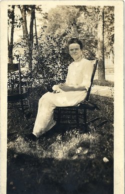
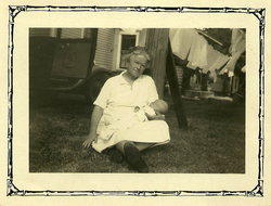
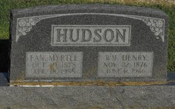
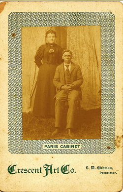
Fannie Myrtle Allen Hudson
| Birth | : | 10 Oct 1878 Macon County, Missouri, USA |
| Death | : | 18 Apr 1955 Clarence, Shelby County, Missouri, USA |
| Burial | : | St. James the Great Churchyard, Winscombe, North Somerset Unitary Authority, England |
| Coordinate | : | 51.3059750, -2.8456900 |
| Plot | : | BUNN Block 1 Row 6 Lot 1s |
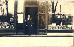
| Description | : | MO d/c 14406 Mrs. Henry Hudson Of Clarence Dies; Funeral Wednesday Mrs. Fannie Myrtle Allen Hudson, 76, died at 1:25 p. m. yesterday at her home in Clarence after she had been in failing health for several years. Funeral services will be held at 2:30 p. m. tomorrow. at the Methodist Church in Clarence, conducted by the Rev. H. L. Rigsby of Macon, assisted by the Rev. Milton Thorne of Clarence. Burial will be at Maplewood Cemetery, Clarence. Mrs. Hudson was the wife of Henry Hudson, who owned and operated a drug store in Clarence for many years, Mr.... Read More |
frequently asked questions (FAQ):
-
Where is Fannie Myrtle Allen Hudson's memorial?
Fannie Myrtle Allen Hudson's memorial is located at: St. James the Great Churchyard, Winscombe, North Somerset Unitary Authority, England.
-
When did Fannie Myrtle Allen Hudson death?
Fannie Myrtle Allen Hudson death on 18 Apr 1955 in Clarence, Shelby County, Missouri, USA
-
Where are the coordinates of the Fannie Myrtle Allen Hudson's memorial?
Latitude: 51.3059750
Longitude: -2.8456900
Family Members:
Parent
Spouse
Siblings

Children
Flowers:


Nearby Cemetories:
1. St. James the Great Churchyard
Winscombe, North Somerset Unitary Authority, England
Coordinate: 51.3059750, -2.8456900
2. Winscombe and Sandford Cemetery
Winscombe, North Somerset Unitary Authority, England
Coordinate: 51.3223861, -2.8386889
3. Saint Andrew Churchyard
Compton Bishop, Sedgemoor District, England
Coordinate: 51.2943290, -2.8678900
4. St. Andrew's Churchyard
Banwell, North Somerset Unitary Authority, England
Coordinate: 51.3280700, -2.8637000
5. Banwell War Memorial
Banwell, North Somerset Unitary Authority, England
Coordinate: 51.3278233, -2.8648124
6. St. John the Baptist Churchyard
Axbridge, Sedgemoor District, England
Coordinate: 51.2876300, -2.8162900
7. The Blessed Virgin Mary
Axbridge, Sedgemoor District, England
Coordinate: 51.3112017, -2.8913443
8. St Leonard's Churchyard
Shipham, Sedgemoor District, England
Coordinate: 51.3130980, -2.8001830
9. St. Michael Sanatorium Cemetery
Axbridge, Sedgemoor District, England
Coordinate: 51.2904100, -2.8056900
10. Shipham Cemetery
Shipham, Sedgemoor District, England
Coordinate: 51.3201930, -2.7992390
11. St Andrew's Church
Loxton, North Somerset Unitary Authority, England
Coordinate: 51.2981560, -2.8962140
12. St Gregory Churchyard
Weare, Sedgemoor District, England
Coordinate: 51.2699900, -2.8408600
13. St Michael and All Angels
Rowberrow, North Somerset Unitary Authority, England
Coordinate: 51.3240000, -2.7915000
14. St Congar Churchyard
Badgworth, Sedgemoor District, England
Coordinate: 51.2699300, -2.8674000
15. St. John the Baptist Churchyard
Biddisham, Sedgemoor District, England
Coordinate: 51.2764090, -2.8878950
16. Saint John the Baptist Churchyard
Churchill, North Somerset Unitary Authority, England
Coordinate: 51.3384750, -2.8092710
17. Methodist Church Burial Ground
Churchill, North Somerset Unitary Authority, England
Coordinate: 51.3344140, -2.8000610
18. St. Augustine's Parish Churchyard
Locking, North Somerset Unitary Authority, England
Coordinate: 51.3322900, -2.9147683
19. Cheddar Baptist Burial Ground
Cheddar, Sedgemoor District, England
Coordinate: 51.2767330, -2.7792010
20. St Mary's Church
Lower Langford, North Somerset Unitary Authority, England
Coordinate: 51.3399805, -2.7813469
21. St. Andrew's Churchyard
Cheddar, Sedgemoor District, England
Coordinate: 51.2736740, -2.7761330
22. St Mary the Virgin Churchyard
Hutton, North Somerset Unitary Authority, England
Coordinate: 51.3228030, -2.9306350
23. Allerton Churchyard
Chapel Allerton, Sedgemoor District, England
Coordinate: 51.2479860, -2.8482400
24. Holy Saviour Churchyard
Puxton, North Somerset Unitary Authority, England
Coordinate: 51.3652680, -2.8536510