
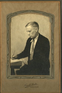
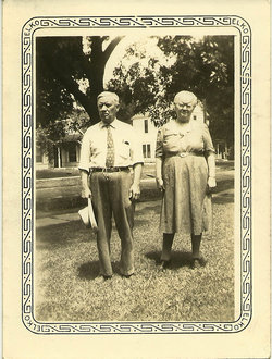
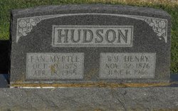
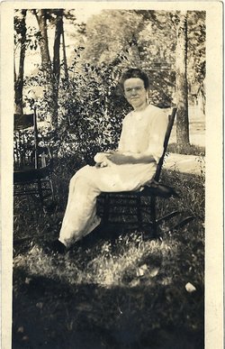
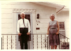
William Henry Hudson
| Birth | : | 22 Nov 1876 Shelby County, Missouri, USA |
| Death | : | 4 Jun 1966 Shelbina, Shelby County, Missouri, USA |
| Burial | : | St. James the Great Churchyard, Winscombe, North Somerset Unitary Authority, England |
| Coordinate | : | 51.3059750, -2.8456900 |
| Plot | : | BUNN Block 1 Row 6 Lot 1s |
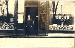
| Description | : | Occupation: Druggist—Pharmacy MO d/c 66 0026876 (Contributor: Pam Witherow) Luther Hudson's Brother Dies; Funeral Today William Henry Hudson, 89, Clarence, died Saturday morning at 11:30 o'clock at the Washburn Rest Home in Shelbina where he had been a patient for two years. Among the survivors are a brother, L. C. Hudson, Moberly; and a son, Denver Hudson Mexico. Funeral services were held this afternoon at 2 o'clock a the Greening Funeral Home Clarence and burial was in Maple Wood Cemetery, Clarence. Moberly Monitor-Index, Moberly, Missouri, 13 Jun 1966, Mon • Page 6, Column 4 (Contributor: Pam Witherow) |
frequently asked questions (FAQ):
-
Where is William Henry Hudson's memorial?
William Henry Hudson's memorial is located at: St. James the Great Churchyard, Winscombe, North Somerset Unitary Authority, England.
-
When did William Henry Hudson death?
William Henry Hudson death on 4 Jun 1966 in Shelbina, Shelby County, Missouri, USA
-
Where are the coordinates of the William Henry Hudson's memorial?
Latitude: 51.3059750
Longitude: -2.8456900
Family Members:
Parent

Spouse
Siblings
Children
Flowers:


Nearby Cemetories:
1. St. James the Great Churchyard
Winscombe, North Somerset Unitary Authority, England
Coordinate: 51.3059750, -2.8456900
2. Winscombe and Sandford Cemetery
Winscombe, North Somerset Unitary Authority, England
Coordinate: 51.3223861, -2.8386889
3. Saint Andrew Churchyard
Compton Bishop, Sedgemoor District, England
Coordinate: 51.2943290, -2.8678900
4. St. Andrew's Churchyard
Banwell, North Somerset Unitary Authority, England
Coordinate: 51.3280700, -2.8637000
5. Banwell War Memorial
Banwell, North Somerset Unitary Authority, England
Coordinate: 51.3278233, -2.8648124
6. St. John the Baptist Churchyard
Axbridge, Sedgemoor District, England
Coordinate: 51.2876300, -2.8162900
7. The Blessed Virgin Mary
Axbridge, Sedgemoor District, England
Coordinate: 51.3112017, -2.8913443
8. St Leonard's Churchyard
Shipham, Sedgemoor District, England
Coordinate: 51.3130980, -2.8001830
9. St. Michael Sanatorium Cemetery
Axbridge, Sedgemoor District, England
Coordinate: 51.2904100, -2.8056900
10. Shipham Cemetery
Shipham, Sedgemoor District, England
Coordinate: 51.3201930, -2.7992390
11. St Andrew's Church
Loxton, North Somerset Unitary Authority, England
Coordinate: 51.2981560, -2.8962140
12. St Gregory Churchyard
Weare, Sedgemoor District, England
Coordinate: 51.2699900, -2.8408600
13. St Michael and All Angels
Rowberrow, North Somerset Unitary Authority, England
Coordinate: 51.3240000, -2.7915000
14. St Congar Churchyard
Badgworth, Sedgemoor District, England
Coordinate: 51.2699300, -2.8674000
15. St. John the Baptist Churchyard
Biddisham, Sedgemoor District, England
Coordinate: 51.2764090, -2.8878950
16. Saint John the Baptist Churchyard
Churchill, North Somerset Unitary Authority, England
Coordinate: 51.3384750, -2.8092710
17. Methodist Church Burial Ground
Churchill, North Somerset Unitary Authority, England
Coordinate: 51.3344140, -2.8000610
18. St. Augustine's Parish Churchyard
Locking, North Somerset Unitary Authority, England
Coordinate: 51.3322900, -2.9147683
19. Cheddar Baptist Burial Ground
Cheddar, Sedgemoor District, England
Coordinate: 51.2767330, -2.7792010
20. St Mary's Church
Lower Langford, North Somerset Unitary Authority, England
Coordinate: 51.3399805, -2.7813469
21. St. Andrew's Churchyard
Cheddar, Sedgemoor District, England
Coordinate: 51.2736740, -2.7761330
22. St Mary the Virgin Churchyard
Hutton, North Somerset Unitary Authority, England
Coordinate: 51.3228030, -2.9306350
23. Allerton Churchyard
Chapel Allerton, Sedgemoor District, England
Coordinate: 51.2479860, -2.8482400
24. Holy Saviour Churchyard
Puxton, North Somerset Unitary Authority, England
Coordinate: 51.3652680, -2.8536510