
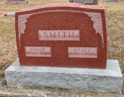
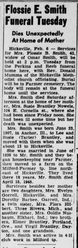

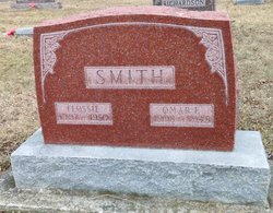
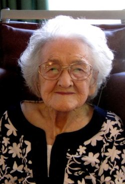
Florence “Flossie” Brantley Smith
| Birth | : | 23 Jun 1907 USA |
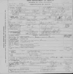
| Death | : | 4 Feb 1950 Defiance County, Ohio, USA |
| Burial | : | Farmer Cemetery, Farmer, Defiance County, USA |
| Coordinate | : | 41.3903008, -84.6410980 |
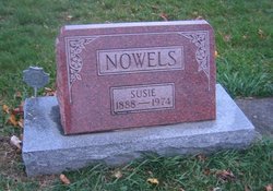
| Description | : | Florence was the adopted daughter of Lee Pryor Brantley and Susan E. Tartar. She was the daughter of Susan's brother, William, whose wife, Bessie, passed away. Her death certificate indicates she was born in Anchor, Illinois, but all of her census records indicate Tennessee. She had a twin sister named Flora. |
frequently asked questions (FAQ):
-
Where is Florence “Flossie” Brantley Smith's memorial?
Florence “Flossie” Brantley Smith's memorial is located at: Farmer Cemetery, Farmer, Defiance County, USA.
-
When did Florence “Flossie” Brantley Smith death?
Florence “Flossie” Brantley Smith death on 4 Feb 1950 in Defiance County, Ohio, USA
-
Where are the coordinates of the Florence “Flossie” Brantley Smith's memorial?
Latitude: 41.3903008
Longitude: -84.6410980
Family Members:
Parent
Spouse
Siblings
Flowers:


Nearby Cemetories:
1. Farmer Cemetery
Farmer, Defiance County, USA
Coordinate: 41.3903008, -84.6410980
2. Upper Lost Creek Cemetery
Farmer, Defiance County, USA
Coordinate: 41.3840000, -84.6700000
3. Kemp Cemetery
Defiance County, USA
Coordinate: 41.3703003, -84.6802979
4. Lost Creek Cemetery
Farmer, Defiance County, USA
Coordinate: 41.3553000, -84.6700000
5. Williams Center Cemetery
Williams Center, Williams County, USA
Coordinate: 41.4288902, -84.6125031
6. Tamarack Cemetery
Milford Township, Defiance County, USA
Coordinate: 41.4117012, -84.7089005
7. Zion Lutheran Church Cemetery
Defiance County, USA
Coordinate: 41.4261017, -84.7099991
8. Fetters Cemetery
Williams County, USA
Coordinate: 41.4519500, -84.6159900
9. Melbern-Neihardt Cemetery
Melbern, Williams County, USA
Coordinate: 41.4633600, -84.6416330
10. Lintz Cemetery
Ney, Defiance County, USA
Coordinate: 41.3760986, -84.5402985
11. Trinity Lutheran Cemetery
Ney, Defiance County, USA
Coordinate: 41.4016991, -84.5353012
12. Yackee Cemetery
Williams County, USA
Coordinate: 41.4707985, -84.6324997
13. Ney Cemetery
Ney, Defiance County, USA
Coordinate: 41.3856010, -84.5271988
14. Six Corners Cemetery
Hicksville, Defiance County, USA
Coordinate: 41.3213997, -84.7153015
15. Saint Johns Lutheran Cemetery
Sherwood, Defiance County, USA
Coordinate: 41.3092003, -84.5931015
16. Doud Cemetery
Ney, Defiance County, USA
Coordinate: 41.3811680, -84.5161110
17. Fountain Grove Cemetery
Bryan, Williams County, USA
Coordinate: 41.4572182, -84.5480576
18. Thomas Cemetery
Williams County, USA
Coordinate: 41.4769100, -84.6994240
19. Brown Cemetery
Bryan, Williams County, USA
Coordinate: 41.4822006, -84.5935974
20. Maple Grove Cemetery
Edgerton, Williams County, USA
Coordinate: 41.4435997, -84.7521973
21. St. Mary's Cemetery
Edgerton, Williams County, USA
Coordinate: 41.4441120, -84.7542700
22. Clarksville Cemetery
Edgerton, Williams County, USA
Coordinate: 41.4281006, -84.7677994
23. Auglaize Village Cemetery
Defiance, Defiance County, USA
Coordinate: 41.3399760, -84.5165610
24. Funk Cemetery
Defiance County, USA
Coordinate: 41.3396988, -84.5164032