
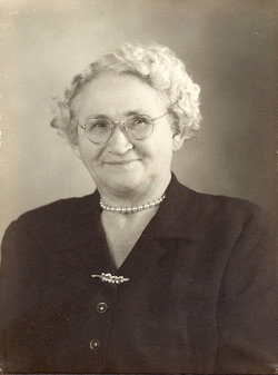
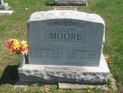
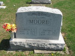
Florence M Yeager Moore
| Birth | : | 3 Jul 1878 Indiana, USA |
| Death | : | 18 Jun 1962 Sullivan, Sullivan County, Indiana, USA |
| Burial | : | St Wilfrid's Churchyard, Halton, City of Lancaster, England |
| Coordinate | : | 54.0759400, -2.7672600 |
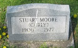
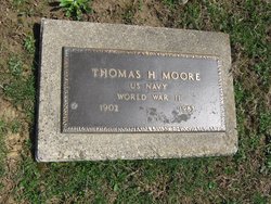
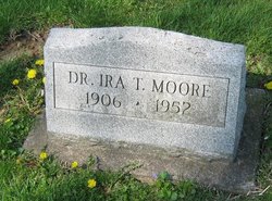
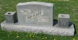
| Description | : | also mother of: Mildred Moore Burdette & James R. Moore Sullivan Daily Times June 19, 1962 Mrs. Florence Moore Dies at Hospital Mrs. Florence Moore, 83, widow of the late Thomas H. Moore of Sullivan, passed away at 10:50 p.m. Monday at the Mary Sherman Hospital where she was admitted Monday morning following a cerebral hemorrhage. The family residence was at 607 N. Court Street. She was a member of the First Methodist Church. Mr. Moore passed away in 1945. A son, Dr. Ira T. Moore who was a prominent physician in California, died in 1952. She was the daughter of the late S.S. and Anna Burnett... Read More |
frequently asked questions (FAQ):
-
Where is Florence M Yeager Moore's memorial?
Florence M Yeager Moore's memorial is located at: St Wilfrid's Churchyard, Halton, City of Lancaster, England.
-
When did Florence M Yeager Moore death?
Florence M Yeager Moore death on 18 Jun 1962 in Sullivan, Sullivan County, Indiana, USA
-
Where are the coordinates of the Florence M Yeager Moore's memorial?
Latitude: 54.0759400
Longitude: -2.7672600
Family Members:
Parent

Spouse
Siblings
Children
Flowers:


Nearby Cemetories:
1. St Wilfrid's Churchyard
Halton, City of Lancaster, England
Coordinate: 54.0759400, -2.7672600
2. Skerton Cemetery
Lancaster, City of Lancaster, England
Coordinate: 54.0651430, -2.7951140
3. Slyne Cemetery
Slyne, City of Lancaster, England
Coordinate: 54.0868185, -2.7969423
4. Lancaster Cemetery
Lancaster, City of Lancaster, England
Coordinate: 54.0504210, -2.7768760
5. Saint Luke's Parish Churchyard
Skerton, City of Lancaster, England
Coordinate: 54.0564700, -2.7982600
6. Christ Church United Reform Church
Bolton-le-Sands, City of Lancaster, England
Coordinate: 54.1015860, -2.7929000
7. Holy Trinity Churchyard
Bolton-le-Sands, City of Lancaster, England
Coordinate: 54.1027700, -2.7911700
8. Nether Kellet Congregational Church
Nether Kellet, City of Lancaster, England
Coordinate: 54.1070772, -2.7587630
9. St. John the Evangelist Churchyard
Lancaster, City of Lancaster, England
Coordinate: 54.0504000, -2.7990000
10. Lancaster and Morecambe Crematorium
Lancaster, City of Lancaster, England
Coordinate: 54.0650890, -2.8198420
11. Cathedral Cemetery of Lancaster
Lancaster, City of Lancaster, England
Coordinate: 54.0471170, -2.7942920
12. St. Nicholas Street Chapel Churchyard
Lancaster, City of Lancaster, England
Coordinate: 54.0486900, -2.7987900
13. Lancaster Priory
Lancaster, City of Lancaster, England
Coordinate: 54.0507360, -2.8057850
14. Lancaster Castle Cemetery
Lancaster, City of Lancaster, England
Coordinate: 54.0494330, -2.8047890
15. Friends Meeting House Burial Ground
Lancaster, City of Lancaster, England
Coordinate: 54.0482500, -2.8058025
16. Mount Street Congregational Chapel
Lancaster, City of Lancaster, England
Coordinate: 54.0468260, -2.8027430
17. St. Paul Churchyard
Caton, City of Lancaster, England
Coordinate: 54.0757840, -2.7009980
18. St Peter's Churchyard
Quernmore, City of Lancaster, England
Coordinate: 54.0367200, -2.7375400
19. Torrisholme Cemetery
Morecambe, City of Lancaster, England
Coordinate: 54.0638980, -2.8409800
20. St Cuthbert Churchyard
Over Kellet, City of Lancaster, England
Coordinate: 54.1195480, -2.7318200
21. Carnforth Cemetery
Carnforth, City of Lancaster, England
Coordinate: 54.1245420, -2.7587820
22. Scotforth Cemetery
Scotforth, City of Lancaster, England
Coordinate: 54.0282250, -2.8007170
23. Holy Trinity Church Poulton-le-Sands
Morecambe, City of Lancaster, England
Coordinate: 54.0744769, -2.8569331
24. Morecambe Cemetery
Morecambe, City of Lancaster, England
Coordinate: 54.0759090, -2.8572610