
Florence Venina Blake Spurlock
| Birth | : | 6 May 1904 Glenwood, Mason County, West Virginia, USA |
| Death | : | 9 Dec 1993 Circleville, Pickaway County, Ohio, USA |
| Burial | : | Scotforth Cemetery, Scotforth, City of Lancaster, England |
| Coordinate | : | 54.0282250, -2.8007170 |
| Plot | : | Section II, Lot 50, Space D |
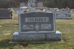
| Inscription | : | S P U R L O C K IVAN FLORENCE 1894 - 1964 1904 - 1993 |
| Description | : | Daughter of Albert Blake & Laura Ellen Smith. |
frequently asked questions (FAQ):
-
Where is Florence Venina Blake Spurlock's memorial?
Florence Venina Blake Spurlock's memorial is located at: Scotforth Cemetery, Scotforth, City of Lancaster, England.
-
When did Florence Venina Blake Spurlock death?
Florence Venina Blake Spurlock death on 9 Dec 1993 in Circleville, Pickaway County, Ohio, USA
-
Where are the coordinates of the Florence Venina Blake Spurlock's memorial?
Latitude: 54.0282250
Longitude: -2.8007170
Family Members:
Parent
Spouse
Siblings

Children
Flowers:


Nearby Cemetories:
1. Scotforth Cemetery
Scotforth, City of Lancaster, England
Coordinate: 54.0282250, -2.8007170
2. Mount Street Congregational Chapel
Lancaster, City of Lancaster, England
Coordinate: 54.0468260, -2.8027430
3. Cathedral Cemetery of Lancaster
Lancaster, City of Lancaster, England
Coordinate: 54.0471170, -2.7942920
4. Friends Meeting House Burial Ground
Lancaster, City of Lancaster, England
Coordinate: 54.0482500, -2.8058025
5. St. Nicholas Street Chapel Churchyard
Lancaster, City of Lancaster, England
Coordinate: 54.0486900, -2.7987900
6. Lancaster Castle Cemetery
Lancaster, City of Lancaster, England
Coordinate: 54.0494330, -2.8047890
7. St. John the Evangelist Churchyard
Lancaster, City of Lancaster, England
Coordinate: 54.0504000, -2.7990000
8. Lancaster Priory
Lancaster, City of Lancaster, England
Coordinate: 54.0507360, -2.8057850
9. Lancaster Cemetery
Lancaster, City of Lancaster, England
Coordinate: 54.0504210, -2.7768760
10. Saint Luke's Parish Churchyard
Skerton, City of Lancaster, England
Coordinate: 54.0564700, -2.7982600
11. St John’s Church Graveyard
Ellel, City of Lancaster, England
Coordinate: 53.9990010, -2.7846660
12. St. Helen's Churchyard
Overton, City of Lancaster, England
Coordinate: 54.0111620, -2.8552950
13. Skerton Cemetery
Lancaster, City of Lancaster, England
Coordinate: 54.0651430, -2.7951140
14. Quernmore Methodist Churchyard
Quernmore, City of Lancaster, England
Coordinate: 54.0259440, -2.7361400
15. St Peter's Churchyard
Quernmore, City of Lancaster, England
Coordinate: 54.0367200, -2.7375400
16. Lancaster and Morecambe Crematorium
Lancaster, City of Lancaster, England
Coordinate: 54.0650890, -2.8198420
17. Christ Church of Glasson Churchyard
Glasson, City of Lancaster, England
Coordinate: 53.9966870, -2.8421460
18. Torrisholme Cemetery
Morecambe, City of Lancaster, England
Coordinate: 54.0638980, -2.8409800
19. St Thomas with Elizabeth Churchyard
Thurnham, City of Lancaster, England
Coordinate: 53.9819990, -2.8159520
20. St Wilfrid's Churchyard
Halton, City of Lancaster, England
Coordinate: 54.0759400, -2.7672600
21. St. Mary's Chapel Ellel Grange
Ellel, City of Lancaster, England
Coordinate: 53.9756944, -2.7918522
22. Hale Carr Lane Cemetery
Morecambe, City of Lancaster, England
Coordinate: 54.0520500, -2.8833940
23. Holy Trinity Church Poulton-le-Sands
Morecambe, City of Lancaster, England
Coordinate: 54.0744769, -2.8569331
24. Morecambe Cemetery
Morecambe, City of Lancaster, England
Coordinate: 54.0759090, -2.8572610