
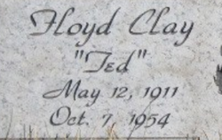
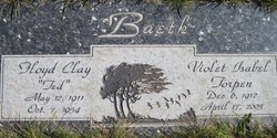
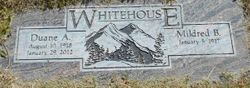
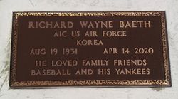
Floyd Clay “Ted” Baeth
| Birth | : | 12 May 1911 Malta, Phillips County, Montana, USA |
| Death | : | 7 Oct 1954 Lincoln County, Montana, USA |
| Burial | : | Purewa Cemetery, Meadowbank, Auckland Council, New Zealand |
| Coordinate | : | -36.8674300, 174.8297900 |
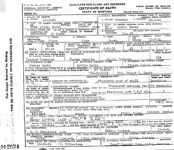
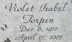
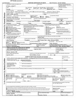
| Description | : | Killed while working in the woods. Montana, County Births and Deaths Name: Floyd Clay Baeth Gender: Male Death Age: 43 Birth Date: 12 May 1911 Birth Place: Malta, Montana Death Date: 7 Oct 1954 Death Place: Libby, Rural, Lincoln, Montana Father: George Baeth Mother: Myrtle Baeth Spouse: Violet Isabel Baeth U.S. WWII Draft Cards Young Men Name: Floyd Clay Baeth Gender: Male Race: White Age: 29 Relationship to Draftee: Self (Head) Birth Place: Malta, Montana, USA Birth Date: 12 May... Read More |
frequently asked questions (FAQ):
-
Where is Floyd Clay “Ted” Baeth's memorial?
Floyd Clay “Ted” Baeth's memorial is located at: Purewa Cemetery, Meadowbank, Auckland Council, New Zealand.
-
When did Floyd Clay “Ted” Baeth death?
Floyd Clay “Ted” Baeth death on 7 Oct 1954 in Lincoln County, Montana, USA
-
Where are the coordinates of the Floyd Clay “Ted” Baeth's memorial?
Latitude: -36.8674300
Longitude: 174.8297900
Family Members:
Parent
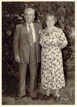

Spouse
Siblings


Nearby Cemetories:
1. Purewa Cemetery
Meadowbank, Auckland Council, New Zealand
Coordinate: -36.8674300, 174.8297900
2. Ōrākei (Rautara St) Urupā
Orakei, Auckland Council, New Zealand
Coordinate: -36.8610770, 174.8188960
3. St. John’s College Graveyard
Saint Johns, Auckland Council, New Zealand
Coordinate: -36.8738169, 174.8416826
4. St. Thomas Churchyard
Tamaki, Auckland Council, New Zealand
Coordinate: -36.8675590, 174.8460560
5. Savage Memorial
Auckland, Auckland Council, New Zealand
Coordinate: -36.8462500, 174.8259300
6. Point England Presbyterian Cemetery
Point England, Auckland Council, New Zealand
Coordinate: -36.8823420, 174.8601550
7. St. Stephen's Churchyard
Auckland, Auckland Council, New Zealand
Coordinate: -36.8504860, 174.7899970
8. St Mark's Anglican Church Cemetery
Remuera, Auckland Council, New Zealand
Coordinate: -36.8729300, 174.7801600
9. St. Patrick's Roman Catholic Church Cemetery
Panmure, Auckland Council, New Zealand
Coordinate: -36.9029680, 174.8564960
10. St Matthias Churchyard
Panmure, Auckland Council, New Zealand
Coordinate: -36.9053300, 174.8577200
11. Royal New Zealand Navy Memorial
Devonport, Auckland Council, New Zealand
Coordinate: -36.8305900, 174.7898900
12. Mount Victoria Cemetery
Devonport, Auckland Council, New Zealand
Coordinate: -36.8252490, 174.7978140
13. Mount Eden Stockade Cemetery
Mount Eden, Auckland Council, New Zealand
Coordinate: -36.8678370, 174.7666430
14. Symonds Street Cemetery
Auckland, Auckland Council, New Zealand
Coordinate: -36.8582828, 174.7636628
15. Saint Andrew's Churchyard
Epsom, Auckland Council, New Zealand
Coordinate: -36.8937200, 174.7654100
16. Pakuranga Methodist Cemetery
Pakuranga, Auckland Council, New Zealand
Coordinate: -36.9054000, 174.8914900
17. Our Lady of the Assumption Catholic Church
Ōnehunga, Auckland Council, New Zealand
Coordinate: -36.9223690, 174.7884530
18. Onehunga Catholic Cemetery
Ōnehunga, Auckland Council, New Zealand
Coordinate: -36.9224360, 174.7884560
19. St. Peter's Anglican Cemetery
Ōnehunga, Auckland Council, New Zealand
Coordinate: -36.9227113, 174.7847550
20. Waikaraka Cemetery
Ōnehunga, Auckland Council, New Zealand
Coordinate: -36.9297140, 174.7967170
21. O'Neill's Point Cemetery
Belmont, Auckland Council, New Zealand
Coordinate: -36.8103002, 174.7812784
22. Howick Historical Village
Pakuranga, Auckland Council, New Zealand
Coordinate: -36.9067680, 174.9027080
23. Holy Trinity Memorial Park
Ōtāhūhū, Auckland Council, New Zealand
Coordinate: -36.9374510, 174.8448580
24. Otahuhu Public Cemetery
Ōtāhūhū, Auckland Council, New Zealand
Coordinate: -36.9377500, 174.8432390