
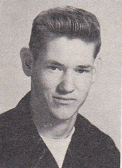
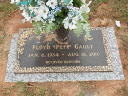
Floyd Eugene “Pete” Gault
| Birth | : | 6 Jan 1934 Union, Union County, South Carolina, USA |
| Death | : | 18 Aug 2010 Spartanburg, Spartanburg County, South Carolina, USA |
| Burial | : | St Mary's Churchyard, Burford, Shropshire Unitary Authority, England |
| Coordinate | : | 52.3087670, -2.6126000 |
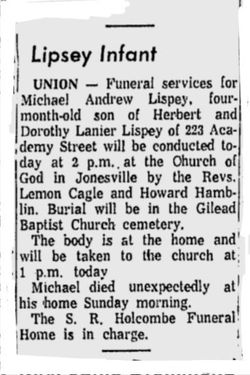
| Description | : | UNION, SC Mr. Floyd Eugene "Pete" Gault, 76, of Union, SC, died Wednesday, August 18, 2010 at Regional Hospice House. Mr. Gault was born in Union County, SC, on January 6, 1934, a son of the late Dorothy Gault Lipsey. He was a 1955 graduate of Jonesville High School and retired from Excelsior Mills and Carlisle Finishing. Mr. Gault was of the Methodist faith. Surviving are a sister, Marie Knox of Union; a brother, Richard Gault and wife Dianne of Jonesville; two nieces, Amy Knox of Union and Gay Gault of Jonesville; a nephew, Chad Gault and wife Melissa of Pauline; two special... Read More |
frequently asked questions (FAQ):
-
Where is Floyd Eugene “Pete” Gault's memorial?
Floyd Eugene “Pete” Gault's memorial is located at: St Mary's Churchyard, Burford, Shropshire Unitary Authority, England.
-
When did Floyd Eugene “Pete” Gault death?
Floyd Eugene “Pete” Gault death on 18 Aug 2010 in Spartanburg, Spartanburg County, South Carolina, USA
-
Where are the coordinates of the Floyd Eugene “Pete” Gault's memorial?
Latitude: 52.3087670
Longitude: -2.6126000
Family Members:
Parent
Siblings
Flowers:


Nearby Cemetories:
1. St Mary's Churchyard
Burford, Shropshire Unitary Authority, England
Coordinate: 52.3087670, -2.6126000
2. St. Mary's Churchyard
Tenbury Wells, Malvern Hills District, England
Coordinate: 52.3120500, -2.5962400
3. St Michael's Churchyard Extension
Tenbury Wells, Malvern Hills District, England
Coordinate: 52.2941032, -2.6183906
4. St Michael and All Angels Churchyard
Tenbury Wells, Malvern Hills District, England
Coordinate: 52.2882600, -2.6137900
5. St. Mary Magdalene Churchyard
Little Hereford, Herefordshire Unitary Authority, England
Coordinate: 52.3112129, -2.6572039
6. St Michael and All Angels Churchyard
Rochford, Malvern Hills District, England
Coordinate: 52.3134240, -2.5454090
7. St Michael & All Angels Churchyard
Knighton-on-Teme, Malvern Hills District, England
Coordinate: 52.3260900, -2.5393500
8. St. Mary's Churchyard
Caynham, Shropshire Unitary Authority, England
Coordinate: 52.3558260, -2.6564540
9. St Marys Churchyard
Kyre, Malvern Hills District, England
Coordinate: 52.2685140, -2.5488360
10. St. Peter's Churchyard
Coreley, Shropshire Unitary Authority, England
Coordinate: 52.3627780, -2.5694950
11. St. Andrew, Ashford Bowdler.
Ashford Bowdler, Shropshire Unitary Authority, England
Coordinate: 52.3308770, -2.7065930
12. Knowbury, St Paul
Caynham, Shropshire Unitary Authority, England
Coordinate: 52.3734750, -2.6300130
13. St Peter & St Paul Churchyard
Eastham, Malvern Hills District, England
Coordinate: 52.3156100, -2.5046000
14. St. Peter's Churchyard
Stoke Bliss, Malvern Hills District, England
Coordinate: 52.2627200, -2.5121300
15. St. James the Less Churchyard
Kimbolton, Herefordshire Unitary Authority, England
Coordinate: 52.2507757, -2.6957349
16. St. John the Baptist Churchyard
Doddington, Cheshire East Unitary Authority, England
Coordinate: 52.3822068, -2.5651644
17. St Lawrence Churchyard
Lindridge, Malvern Hills District, England
Coordinate: 52.3180700, -2.4779300
18. St. Mary's Churchyard
Bitterley, Shropshire Unitary Authority, England
Coordinate: 52.3922280, -2.6319790
19. Hopton Bank Methodist Church Burial Ground
Hopton Wafers, Shropshire Unitary Authority, England
Coordinate: 52.3872950, -2.5584430
20. St. Peter and St. Paul
Leominster, Herefordshire Unitary Authority, England
Coordinate: 52.2704100, -2.7398260
21. St. Michael & All Angels Churchyard
Hopton Wafers, Shropshire Unitary Authority, England
Coordinate: 52.3857100, -2.5343700
22. St John the Baptist Churchyard
Mamble, Malvern Hills District, England
Coordinate: 52.3416520, -2.4586520
23. St Mary the Virgin
Cleobury Mortimer, Shropshire Unitary Authority, England
Coordinate: 52.3792280, -2.4803610
24. St Bartholomews Churchyard
Bayton, Malvern Hills District, England
Coordinate: 52.3562100, -2.4548200