
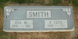
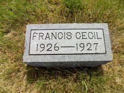
Francis Cecil Smith
| Birth | : | 4 Apr 1900 Harrison County, Iowa, USA |
| Death | : | 6 May 1971 Council Bluffs, Pottawattamie County, Iowa, USA |
| Burial | : | Tonkawa IOOF Cemetery, Tonkawa, Kay County, USA |
| Coordinate | : | 36.6955800, -97.3242300 |
| Plot | : | Block 25, Row 8 |
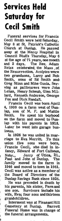
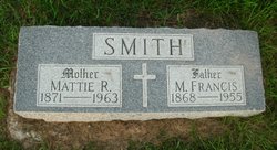
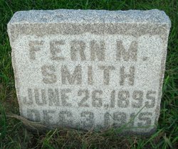
| Description | : | Dunlap Reporter, Dunlap, Iowa, Thursday, May 13th, 1971 Page 1 Services Held Saturday for Cecil Smith Funeral services for Francis Cecil Smith were held Saturday, May 8 at St. Patrick's Catholic Church at Dunlap. He passed away at the Mercy Hospital in Council Bluffs Thursday, May 6 at the age of 71 years, one month and 2 days. The Rev. Adam Reisz celebrated,, the Mass of the Resurrection. Acolytes were two grandsons, Larry and Bob Smith, sons of Ed Smith and Greg Stinn and Mike Gunia. Serving as pallbearers were John Lehan, Henry Schwab, Glen Millard,... Read More |
frequently asked questions (FAQ):
-
Where is Francis Cecil Smith's memorial?
Francis Cecil Smith's memorial is located at: Tonkawa IOOF Cemetery, Tonkawa, Kay County, USA.
-
When did Francis Cecil Smith death?
Francis Cecil Smith death on 6 May 1971 in Council Bluffs, Pottawattamie County, Iowa, USA
-
Where are the coordinates of the Francis Cecil Smith's memorial?
Latitude: 36.6955800
Longitude: -97.3242300
Family Members:
Parent

Spouse

Siblings
Children

Flowers:


Nearby Cemetories:
1. Tonkawa IOOF Cemetery
Tonkawa, Kay County, USA
Coordinate: 36.6955800, -97.3242300
2. Tonkawa Indian Cemetery
Tonkawa, Kay County, USA
Coordinate: 36.6726100, -97.2643800
3. Blackwell Cemetery
Blackwell, Kay County, USA
Coordinate: 36.7752991, -97.2809982
4. River View Cemetery
Alcorn, Kay County, USA
Coordinate: 36.6300621, -97.4076996
5. Prairie View Cemetery
Tonkawa, Kay County, USA
Coordinate: 36.6002998, -97.3003006
6. Round Grove Cemetery
Tonkawa, Kay County, USA
Coordinate: 36.7094002, -97.1967010
7. Eddy New Home Cemetery
Grant County, USA
Coordinate: 36.7311600, -97.4802800
8. Grandview Cemetery
Marland, Noble County, USA
Coordinate: 36.5649400, -97.2792200
9. Mount Olive Cemetery
Nardin, Kay County, USA
Coordinate: 36.7957993, -97.4593964
10. Saint Johns Cemetery
Blackwell, Kay County, USA
Coordinate: 36.8252983, -97.1900024
11. Cowboy Hill Cemetery
Ponca City, Kay County, USA
Coordinate: 36.6068993, -97.1380997
12. Oak Grove Cemetery
Ponca City, Kay County, USA
Coordinate: 36.6876500, -97.1072600
13. Odd Fellows Cemetery
Ponca City, Kay County, USA
Coordinate: 36.6893997, -97.1046066
14. Saint Marys Catholic Cemetery
Ponca City, Kay County, USA
Coordinate: 36.6875000, -97.1038971
15. Ponca Tribal Cemetery
Ponca City, Kay County, USA
Coordinate: 36.6432991, -97.1132965
16. Mount Vernon Cemetery
Lamont, Grant County, USA
Coordinate: 36.6082993, -97.5167007
17. Prairie Chapel Cemetery
Blackwell, Kay County, USA
Coordinate: 36.7964400, -97.1400700
18. Floral Ridge Cemetery
Billings, Noble County, USA
Coordinate: 36.5139900, -97.3190600
19. Billings Catholic Cemetery
Billings, Noble County, USA
Coordinate: 36.5347700, -97.4348400
20. Bayard Cemetery
Deer Creek, Grant County, USA
Coordinate: 36.7747002, -97.5344009
21. White Eagle Monument
Marland, Noble County, USA
Coordinate: 36.5695300, -97.1448000
22. First Christian Church Columbarium
Ponca City, Kay County, USA
Coordinate: 36.7053210, -97.0788450
23. Billings Union Cemetery
Billings, Noble County, USA
Coordinate: 36.5056000, -97.4163971
24. Lamont Cemetery
Lamont, Grant County, USA
Coordinate: 36.6967010, -97.5792007